Lighthouses
| Name | Image | Year built | Location & coordinates | Class of Light | Focal height | NGA number | Admiralty number | Range nml |
|---|---|---|---|---|---|---|---|---|
| Aéreo de Rincón del Bonete Lighthouse |  | 1938 | Rincón del Bonete Lake 32°49′58.5″S56°25′30.0″W / 32.832917°S 56.425000°W | inactive since 1994 | 7 metres (23 ft) | n/a | n/a | n/a |
| Arroyo Riachuelo East Mole Lighthouse | n/a | 34°27′32.0″S57°43′59.9″W / 34.458889°S 57.733306°W | Fl R 5s. | 107 metres (351 ft) | 19253 | G0745.6 | 5 | |
| Cabo Polonio |  | 1881 | Cabo Polonio 34°24′19.3″S53°46′40.2″W / 34.405361°S 53.777833°W | Fl W 12s. | 40 metres (130 ft) | 19024 | G0662 | 22 |
| Cabo Santa Maria Lighthouse |  | 1874 | La Paloma 34°40′05.5″S54°09′10.6″W / 34.668194°S 54.152944°W | Fl W 60s. | 42 metres (138 ft) | 19032 | G0668 | 20 |
| Colonia del Sacramento Lighthouse |  | 1857 | Colonia del Sacramento 34°28′22.3″S57°51′08.4″W / 34.472861°S 57.852333°W | Fl R 9s. | 34 metres (112 ft) | 19260 | G0756 | 11 |
| El Cerro de Montevideo Lighthouse |  | 1802 | Montevideo 34°53′18.5″S56°15′35.7″W / 34.888472°S 56.259917°W | Fl (3) W 10s. | 148 metres (486 ft) | 19184 | G0702 | 19 |
| Escollera Sarandí Lighthouse | Image | n/a | Montevideo 34°54′48.2″S56°13′20.1″W / 34.913389°S 56.222250°W | Fl R 3s. | 22 metres (72 ft) | 19136 | G0704 | 10 |
| Isla de Farallón Lighthouse | | 1876 | Isla de Farallón 34°29′05.4″S57°55′05.7″W / 34.484833°S 57.918250°W | Fl (2) W 10s. | 26 metres (85 ft) | 19280 | G0762 | 10 |
| Isla de Flores Lighthouse |  | 1828 | Isla de Flores 34°56′45.3″S55°55′57.7″W / 34.945917°S 55.932694°W | Fl (2) W 16s. | 37 metres (121 ft) | 19080 | G0690 | 19 |
| Isla Gorriti Lighthouse | Image | n/a | Gorriti Island 34°57′36.3″S54°58′13.2″W / 34.960083°S 54.970333°W | Fl G 5s. | 9 metres (30 ft) | 19056 | G0683 | 5 |
| Isla de Lobos Lighthouse |  | 1906 | Isla de Lobos 35°01′28.3″S54°53′00.2″W / 35.024528°S 54.883389°W | Fl W 5s. | 66 metres (217 ft) | 19040 | G0676 | 23 |
| Isla Martín García Lighthouse | n/a | Martín García Island 34°11′24.5″S58°15′24.8″W / 34.190139°S 58.256889°W | Fl (2) Y 10s. | 10 metres (33 ft) | 19292 | G0791 | 6 | |
| La Panela Lighthouse | Image | 1984 | Río de la Plata 34°54′54.0″S56°26′54.0″W / 34.915000°S 56.448333°W | Fl (4) 10s. | 17 metres (56 ft) | 19196 | G0736 | 8 |
| Maria Victoria Lighthouse | Image | n/a | La Aguada y Costa Azul 34°38′44.2″S54°09′14.6″W / 34.645611°S 54.154056°W | Fl WR 4s. | 7 metres (23 ft) | 19028 | G0664 | white: 8 red: 6 |
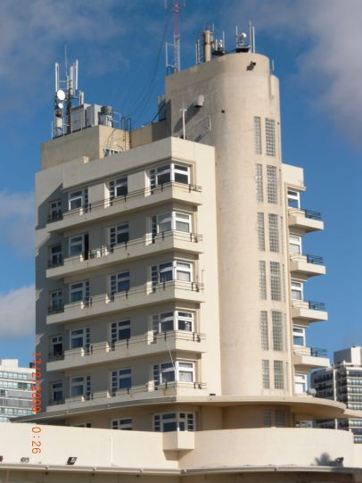
| Montevideo Catedral Lighthouse | Image | 1862 | Montevideo 34°54′25.7″S56°12′14.6″W / 34.907139°S 56.204056°W | inactive since 1910 | 23 metres (75 ft) (tower) | n/a | n/a | n/a |
| Monumento Artigas Lighthouse | Image | n/a | Punta del Diablo 34°02′40.1″S53°32′03.0″W / 34.044472°S 53.534167°W | Fl W 5s. | 15 metres (49 ft) | 19016 | G0658 | 8 |
| Piedra Diamante Lighthouse | Image | n/a | Río de la Plata 34°25′26.8″S57°57′41.0″W / 34.424111°S 57.961389°W | Fl (2) W 6s. | 18 metres (59 ft) | 19284 | G0789 | 10 |
| Piriápolis Outer Breakwater Lighthouse | n/a | Piriápolis 34°52′27.2″S55°16′57.3″W / 34.874222°S 55.282583°W | Fl R 5s. | 10 metres (33 ft) | 19076 | G0689.1 | 8 | |
| Punta Brava Lighthouse |  | 1876 | Punta Carretas 34°56′06.8″S56°09′38.1″W / 34.935222°S 56.160583°W | Al Fl WR 10s. | 21 metres (69 ft) | 19124 | G0700 | 15 |
| Puerto del Buceo East Breakwater Lighthouse | Image | n/a | Buceo 34°54′33.5″S56°07′35.0″W / 34.909306°S 56.126389°W | Fl R 5s. | 7 metres (23 ft) | 19108 | G0698 | 10 |
| Puerto del Buceo West Breakwater Lighthouse | Image | n/a | Buceo 34°54′32.8″S56°07′39.7″W / 34.909111°S 56.127694°W | Fl G 5s. | 13 metres (43 ft) | 19104 | G0696 | 10 |
| Punta del l’Este Lighthouse | 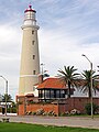 | 1860 | Punta del Este 34°58′07.7″S54°57′05.8″W / 34.968806°S 54.951611°W | Fl W 8s. | 44 metres (144 ft) | 19044 | G0682 | 21 |
| Punta del Este West Breakwater Lighthouse | Image | n/a | Punta del Este 34°57′35.6″S54°57′04.0″W / 34.959889°S 54.951111°W | Fl R 5s. | 7 metres (23 ft) | 19048 | G0684 | 8 |
| Punta José Ignacio Lighthouse |  | 1877 | Maldonado Department 34°50′45.9″S54°37′58.8″W / 34.846083°S 54.633000°W | Fl W 2s. | 32 metres (105 ft) | 19036 | G0672 | 15 |
| Punta Negra Lighthouse | Image | n/a | Punta Negra 34°54′13.4″S55°15′37.1″W / 34.903722°S 55.260306°W | Fl W 5s. | 17 metres (56 ft) | 19068 | G0688 | 7 |
| Punta Palmar Lighthouse |  | 1984 | Punta del Diablo 34°04′01.5″S53°33′04.1″W / 34.067083°S 53.551139°W | Fl W 6s. | 21 metres (69 ft) | 19020 | G0660 | 10 |
| Sebastian Cabot Lighthouse | n/a | San Juan River 34°16′37.7″S57°59′02.6″W / 34.277139°S 57.984056°W | Fl G 5s. | 5 metres (16 ft) | 19287 | G0764 | 5 | |
| Yacht Club Uruguayo Lighthouse | Image | 1939 | Buceo 34°54′35.6″S56°07′51.4″W / 34.909889°S 56.130944°W | Fl W 4s. | 40 metres (130 ft) | 19112 | G0699 | 8 |

