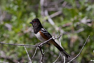
The spotted towhee is a large New World sparrow. The taxonomy of the towhees has been debated in recent decades, and until 1995 this bird and the eastern towhee were considered a single species, the rufous-sided towhee. Another outdated name for the spotted towhee is the Oregon towhee. The call may be harsher and more varied than for the eastern towhee.

Lake Vyrnwy is a reservoir in Powys, Wales, built in the 1880s for Liverpool Corporation Waterworks to supply Liverpool with fresh water. It flooded the head of the Vyrnwy valley and submerged the village of Llanwddyn.

Ben Wyvis is a mountain in Easter Ross, in the northern Highlands of Scotland. It lies north-west of Dingwall, in the council area of Highland, and the county of Ross and Cromarty. Ben Wyvis is a large winding and undulating ridge running roughly north–south for about 5 km, the highest point of which is Glas Leathad Mòr at 1,046 metres (3,432 ft). Geologically, the ridge is composed of Moine pelitic gneiss. The mountain is prominent in views of the area, presenting a whale-back shape above the farmland of Strathconon.
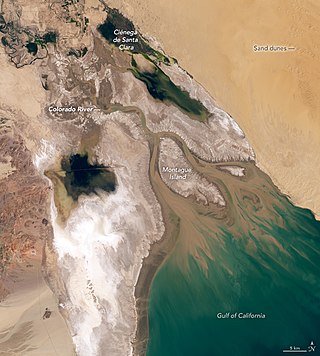
The Colorado River Delta is the region where the Colorado River flows into the Gulf of California in eastern Mexicali Municipality in the north of the state of Baja California in northwesternmost Mexico. The delta is part of a larger geologic region called the Salton Trough. Historically, the interaction of the river's flow and the ocean's tide created a dynamic environment, supporting freshwater, brackish, and saltwater species. Within the delta region, the river split into multiple braided channels and formed a complex estuary and terrestrial ecosystems. The use of water upstream and the accompanying reduction of freshwater flow has resulted in the loss of most of the wetlands of the area, as well as drastic changes to the aquatic ecosystems. However, a scheme is currently in place which aims to rejuvenate the wetlands by releasing a pulse of water down the river delta.

The black-tailed prairie dog is a rodent of the family Sciuridae found in the Great Plains of North America from about the United States-Canada border to the United States-Mexico border. Unlike some other prairie dogs, these animals do not truly hibernate. The black-tailed prairie dog can be seen above ground in midwinter. A black-tailed prairie dog town in Texas was reported to cover 25,000 sq mi (64,000 km2) and included 400,000,000 individuals. Prior to habitat destruction, the species may have been the most abundant prairie dog in central North America. It was one of two prairie dogs described by the Lewis and Clark Expedition in the journals and diaries of their expedition.

Juliana's golden mole is a golden mole endemic to South Africa. It is listed as an endangered species due to habitat loss and a restricted range. Golden moles are an ancient group of mammals that live mostly below ground. The eponymous Juliana is Juliana Meester, the wife of the South African zoologist who named this species.
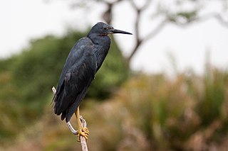
The slaty egret is a small, dark egret. It is one of the species to which the Agreement on the Conservation of African-Eurasian Migratory Waterbirds (AEWA) applies. It is classified as Vulnerable, the biggest threat being habitat loss.

The Hennops River is one of the larger rivers that drains Gauteng, South Africa. It has its source near Kempton Park, east of Johannesburg and meets the Crocodile River shortly before Hartbeespoort Dam. It is one of Gauteng's most polluted rivers.

Roodeplaat Dam is a concrete arch dam situated in South Africa on the Pienaars River, a tributary of the Crocodile River, which flows northwards into the Limpopo River. The dam is a warm monomictic impoundment with stable thermal stratification during the summer.

Alam-Pedja Nature Reserve is the largest nature reserve in Estonia. It is a vast wilderness area which covers 342 km2 and consists of a complex of 5 large bogs separated by unregulated rivers, their floodplains, and extensive forests. The nature reserve aims to protect diverse ecosystems and rare species, mainly through preserving the natural development of forests and bogs and securing the continuing management of semi-natural floodplain grasslands.

The Pienaars River is a river in South Africa. It is a tributary of the Crocodile River. A short section of this river is known as the Moretele River. Tributaries of the Pienaars River include the Moreletaspruit. Note that the above-mentioned Moretele river section is 60 km away from the Moreletaspruit and these two should not be confused with one another.

Sweetbriar Road Meadows is a 9.7-hectare (24-acre) biological Site of Special Scientific Interest in Norwich in Norfolk.

The Clyde Valley Woodlands National Nature Reserve (NNR) comprises six separate woodland sites in the Clyde Valley region of South Lanarkshire, Scotland. These six sites are located along a 12 km section of the River Clyde and its tributaries, and lie close to built-up areas such as Hamilton and Lanark on the southern outskirts of Greater Glasgow. The sites can be easily accessed by about two million people living in the surrounding urban areas, making the reserve unique amongst Scotland's NNRs, most of which tend to be located in more remote areas. The six sites are:

The Groenkloof Nature Reserve, located adjacent to the Fountains Valley at the southern entrance to Pretoria, was the first game sanctuary in Africa. The reserve of 600 ha is managed by the Department of Nature Conservation. The National Heritage Monument is located within the reserve. It is flanked by Christina de Wit Avenue and Nelson Mandela Drive, that separate it from the Voortrekker Monument and Klapperkop Nature Reserves. In aggregate these reserves conserve some 1,400 ha of bankenveld vegetation which is threatened in Gauteng. The reserve is open to day visitors from 5:30 to 19:00 in summer, and 7:00 to 18:00 in winter.

The Austin Roberts (Memorial) Bird Sanctuary is a 11.76 ha nature reserve located in the Walkerspruit Open Space System, in the Nieuw Muckleneuk suburb of Pretoria, South Africa. It became the first bird refuge in Pretoria when it was opened by the then mayor of Pretoria, Mr. W. J. Seymore, on 27 October 1956. It was officially proclaimed as a nature reserve on 26 February 1958, and it was fenced in June 1970.

The Moreleta Kloof Nature Reserve in eastern Pretoria, Gauteng, South Africa, was part of the farm Garsfontein which was acquired by Jacobus Cornelius Rademeyer in 1859. He had married Cornelia Jacoba Susanna Erasmus on 2 Jul 1837 in George, Eastern Cape. Cornelia Erasmus was a daughter of Daniel Jacobus Elardus Erasmus, who was the first settler on the farm Zwartkop, and sister of Daniel Elardus Erasmus who had settled on the farm Doornkloof. Jacobus Rademeyer operated Garsfontein as a dairy farm and Carel Erasmus purchased the farm from him in 1877 and built a house there; the house was later converted into a chapel which is still in use. In 1903, his son-in-law, Johan Marnewick, built another house on the farm; this house has been converted into a restaurant named Rademeyer's. The reserve is managed by the City of Tshwane Metropolitan Municipality and admission is free. The reserve covers 100 hectares.

The Struben Dam Bird Sanctuary is located in Lynnwood Glen, Pretoria, in part of what was once the farm Hartebeestpoort 362 JR, which was owned by F.E.B. Struben.
Jerrabomberra Wetlands Nature Reserve is a nationally important group of small wetlands in central Canberra. The Wetlands area is on a part of the Molonglo River - Jerrabomberra Creek floodplain that became permanently inundated when the Molonglo River was dammed to form Lake Burley Griffin in 1964.
The M1 road is a short metropolitan route in the City of Tshwane in Gauteng, South Africa. It connects Pretoria West and the Pretoria CBD with Pretoria North via Mayville.
The M33 road is a short metropolitan route in the City of Tshwane in Gauteng, South Africa. It consists of only one road in Pretoria East, connecting Constantia Park with Lynnwood Ridge.


