Fair Haven, Vermont

Last updated
Fair Haven, Vermont
Town
Main Street in Fair Haven.jpg
Main Street
Fair haven vt highlight.png
Located in Rutland County, Vermont
Map of USA VT.svg
Location of Vermont with the U.S.A.
Coordinates: 43°36′00″N73°16′06″W / 43.60000°N 73.26833°W / 43.60000; -73.26833 Coordinates: 43°36′00″N73°16′06″W / 43.60000°N 73.26833°W / 43.60000; -73.26833
Country United States
State Vermont
County Rutland
Chartered1779
Government
  ManagerJoseph Gunter
Area
[1]
  Total18.147 sq mi (47.00 km2)
  Land17.444 sq mi (45.18 km2)
  Water0.703 sq mi (1.82 km2)
Population
 (2020)
  Total2,736
  Density150/sq mi (58/km2)
  Households
1,135
  Families
738
ZIP code
05743
Area code 802
Website www.fairhavenvt.org

Fair Haven is a town in Rutland County, Vermont, United States. The population was 2,736 at the 2020 census. [2] Within the town is located the census-designated place of Fair Haven. The town is noted for its late 19th century residential and commercial architecture. [3]

Contents

History

Print of Fair Haven from 1886 by L.R. Burleigh with listing of landmarks Fair Haven, Vt. (2675884692).jpg
Print of Fair Haven from 1886 by L.R. Burleigh with listing of landmarks

Fair Haven was chartered on October 27, 1779, to Ebenezer Allen and 76 associates, and first settled the same year. The township originally included West Haven, which was set off on October 20, 1792. The post office at Fair Haven was established in 1797. [4] In 1783, Colonel Matthew Lyon moved to Fair Haven and began building mills at the falls on the Castleton River. His enterprises included a gristmill, sawmill and papermill, in addition to a forge, as well as a newspaper, the Fair Haven Gazette . This began Fair Haven's legacy as a small, prosperous mill town, which by 1859 included a marble mill, rolling mill, nail factory, papermill producing wallpaper, three sawmills, a wagon shop, a machine shop, two blacksmith shops, and two shoe shops. [5]

The quarrying and manufacture of slate began in 1846. Fair Haven would develop extensive quarries for the stone, believed at the time to be inexhaustible, which was supplied to cities along the Atlantic coast and in the West. Some of it was made into the framed, book-sized writing slates that students of the time used. [5] On April 7, 1880, a very small area of Fair Haven was transferred to New York due to a change in the course in the Poultney River. The area transferred was west of the "middle of the deepest channel" of the river. [6]

Demographics

Historical population
CensusPop.
1790 545
1800 411−24.6%
1810 64556.9%
1820 71410.7%
1830 675−5.5%
1840 633−6.2%
1850 90242.5%
1860 1,37852.8%
1870 2,20860.2%
1880 2,2110.1%
1890 2,79126.2%
1900 2,9997.5%
1910 3,0953.2%
1920 2,540−17.9%
1930 2,6142.9%
1940 2,245−14.1%
1950 2,2861.8%
1960 2,3784.0%
1970 2,77716.8%
1980 2,8191.5%
1990 2,8872.4%
2000 2,9281.4%
2010 2,734−6.6%
2020 2,7360.1%
U.S. Decennial Census [7]

As of the census [8] of 2010, there were 2,734 people and 1,135 households. The population density was 150 people per square mile. The racial makeup of the town was 97.3% White (2,659 people), 0.3% Black or African American (9 people), 0.2% Native American (5 people), 0.4% Asian (12 people), <0.1% Pacific Islander (1 person), 0.5% from other races (14 people), and 1.2% from two or more races (34 people). Hispanic or Latino of any race were 1.3% (36 people).

Of the 1,282 total housing units, 1,135 (88.5%) of the houses were occupied and 147 (11.5%) were vacant. Of the occupied housing units, 755 (66.5%) were occupied by the owners (1,928 people), and 380 (33.5%) were rented (806 people). Of the 147 vacant housing units, 19 (12.9%) were for sale and 78 (53.1%) were for rent. The average number people per household was 2.41.

In the town, the population was spread out, with 1,320 (48.3%) males and 1,414 (51.7%) females. Out of the total population, there were 598 people under the age of 18 (21.9%), 193 (7.1%) between the ages 20–24, 265 (9.7%) within the ages of 25–34, 558 (20.41%) people who are between 35–49, 615 (22.5%) people are 50–64, and 425 (15.5%) people who are 65 and older.

As of 2000 Census, the median income for a household in the town was $34,313, and the median income for a family was $36,587. Males had a median income of $29,760 versus $21,406 for females. The per capita income for the town was $17,912. About 11.4% of families and 15.4% of the population were below the poverty line, including 24.3% of those under age 18 and 8.2% of those age 65 or over.

Geography

According to the United States Census Bureau, the town has a total area of 18.1 square miles (47 km2), of which 17.6 square miles (46 km2) is land and 0.5 square miles (1.3 km2), or 2.70%, is water. Fair Haven is drained by the Poultney River and Castleton River.

To the north, Fair Haven is bordered by Benson. Castleton borders Fair Haven to the east. To the west, Fair Haven is bordered by West Haven, Vermont. Hampton, New York, borders Fair Haven to the south and to the west. In the southeast, Poultney borders Fair Haven.

Government and politics

Fair Haven operates under a town meeting form of government with a town manager and a five-member Selectboard to supervise the local government. It has an annual operating budget of $2.9 million and 29 employees. [9]

The town lacks a mayor, but has a ceremonial mayoral election that is open to pets and animals with a paid submission to raise funds for the local elementary school. In an eighteen-candidate ballot on March 3, 2020, a Cavalier King Charles Spaniel named Murfee was elected as mayor to a one-year term. [10] [11]

Transportation

The town is crossed by a freeway segment of U.S. Route 4, from which three interchanges serve the town. Vermont Route 4A and Vermont Route 22A also pass through Fair Haven as they overlap each other for less than a half mile just south of the town center.

Neighboring cities and towns

Sites of interest

Fair Haven has a large town green, a fountain in the center of the green, and a gazebo at the south end of the green.

Notable people

See also

Related Research Articles

<span class="mw-page-title-main">Rutland County, Vermont</span> County in Vermont, United States

Rutland County is a county located in the U.S. state of Vermont. As of the 2020 census, the population was 60,572, making it the second-most populous county in Vermont. Its county seat and most populous municipality is the city of Rutland.

<span class="mw-page-title-main">Vergennes, Vermont</span> City in Vermont, United States

Vergennes is a city located in the northwest quadrant of Addison County, Vermont, United States. The municipality is bordered by the towns of Ferrisburgh, Panton, and Waltham. As of the 2020 census, its population was 2,553. It is the smallest of Vermont's 10 cities in terms of population, though the city of Winooski covers a smaller area. It was the first city chartered in the state of Vermont.

<span class="mw-page-title-main">Benson, Vermont</span> Town in Vermont, United States

Benson is a town in Rutland County, Vermont, United States. The population was 974 at the 2020 census. The town is rural, with a concentration of several homes and businesses in Benson village, at the intersection of Stage Road and Lake Road. Benson village is the centerpiece of a complex local economy that includes a taco truck, the Wheel Inn tavern, the G & L general store, a museum, a town transfer station, a do-it-yourself furniture store, a library, three antique stores, and a quaint bed and breakfast throughout the town's main road.

<span class="mw-page-title-main">Castleton, Vermont</span> Town in Vermont, United States

Castleton is a town in Rutland County, Vermont, United States. Castleton is about 15 miles (24 km) to the west of Rutland, the county's seat and most populous city, and about 7 miles (11 km) east of the New York/Vermont state border. The town had a population of 4,458 at the 2020 census. Castleton University is located there, with roots dating to 1787.

<span class="mw-page-title-main">Granville, New York</span> Town in New York, United States

Granville is a town on the eastern border of Washington County, New York, United States, abutting Rutland County, Vermont. It is part of the Glens Falls Metropolitan Statistical Area. The town population was 6,215 at the 2020 census.

<span class="mw-page-title-main">Middlebury, Vermont</span> Town in Vermont, United States

Middlebury is the shire town of Addison County, Vermont, United States. As of the 2020 U.S. Census, the population was 9,152. Middlebury is home to Middlebury College and the Henry Sheldon Museum of Vermont History.

<span class="mw-page-title-main">Manchester, Vermont</span> Town in Vermont, United States

Manchester is a town in, and one of two shire towns of, Bennington County, Vermont. The population was 4,484 at the 2020 census.

<span class="mw-page-title-main">Poultney (town), Vermont</span> Town in Vermont, United States

Poultney is a town in Rutland County in the southwestern part of the U.S. state of Vermont. New York state is on its western border. Castleton, Vermont, is on its northern border. Poultney was home to Green Mountain College, a private liberal arts college that closed in 2019. The Village of Poultney is entirely within the town. The town population was 3,020 at the 2020 census.

West Rutland is the central village and a census-designated place (CDP) in the town of West Rutland, Rutland County, Vermont, United States. As of the 2020 census, it had a population of 1,898, out of 2,214 in the entire town of West Rutland.

<span class="mw-page-title-main">Rutland, Vermont (town)</span> Town in Vermont, United States

Rutland is a town in Rutland County, Vermont, in the United States. As of the 2020 census, the population was 3,924. The Town of Rutland completely surrounds the City of Rutland, which is incorporated separately from the town. The villages of the town effectively comprise the inner suburbs of the City of Rutland.

<span class="mw-page-title-main">Rutland, Vermont (city)</span> City in Vermont, United States

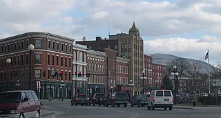
The city of Rutland is the seat of Rutland County, Vermont, United States. As of the 2020 census, the city had a total population of 15,807. It is located approximately 65 miles (105 km) north of the Massachusetts state line, 35 miles (56 km) west of New Hampshire state line, and 20 miles (32 km) east of the New York state line. Rutland is the third largest city in the state of Vermont after Burlington and South Burlington. It is surrounded by the town of Rutland, which is a separate municipality. The downtown area of the city is listed as a historic district on the National Register of Historic Places.

<span class="mw-page-title-main">West Rutland, Vermont</span> Town in Vermont, United States

West Rutland is a town in Rutland County, Vermont, United States. The population was 2,214 at the 2020 census. The town center, located in the south-central portion of the town and where about 87% of the population resides, is defined by the U.S. Census Bureau as a census-designated place (CDP). The town is part of the Rutland micropolitan NECTA.

The Rutland Senate District is one of 13 Vermont Senate districts included in the redistricting and reapportionment plan developed by the Vermont General Assembly following the 2000 U.S. Census. The plan applies to legislatures elected in 2002, 2004, 2006, 2008, and 2010. A new plan will be developed in 2012 following the 2010 U.S. Census.

<span class="mw-page-title-main">Marble Valley Regional Transit District</span>

Marble Valley Regional Transit District (MVRTD) operates a public transportation system in Rutland County, Vermont called The Bus. The company currently has full bus service to Rutland and West Rutland, as well as limited daily bus service to Castleton, Fair Haven, Poultney and Killington. Limited weekday service is available to Ludlow and Proctor. It also provides weekday and Saturday service to Middlebury and Manchester, Vermont. The Bus also operates paratransit and Medicaid Transportation services for Rutland County.

The Rutland and Whitehall Railroad is a defunct railroad which operated in the state of Vermont. The railroad, also known as the Castleton Company, received its charter from Vermont in 1848 and opened in 1850.

The Poultney River is a river in southwestern Vermont and eastern New York. In its 40-mile long course, the river drains approximately 263 square miles as it flows northwards into the southern end of Lake Champlain.

<span class="mw-page-title-main">Fair Haven Green Historic District</span> Historic district in Vermont, United States

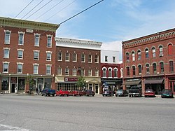
The Fair Haven Green Historic District encompasses the village green of Fair Haven, Vermont, and the heterogeneous collection of civic, commercial, and residential buildings that line it and adjacent streets. The area was developed mainly following the arrival of the railroad in 1848 and the subsequent expansion of marble and slate quarries in the area. The district was listed on the National Register of Historic Places in 1980.

The Rutland Senate District is one of 13 Vermont Senate districts included in the redistricting and reapportionment plan developed by the Vermont General Assembly following the 2010 U.S. Census. The plan applies to legislatures elected in 2012, 2014, 2016, 2018, and 2020. A new plan will be developed in 2022 following the 2020 U.S. Census.

Castleton Four Corners is a census-designated place (CDP) in the town of Castleton, Rutland County, Vermont, United States. It consists of the unincorporated villages of Castleton Corners and Hydeville. As of the 2020 census, the CDP had a population of 699, out of 4,458 in the entire town.

References

  1. "2016 U.S. Gazetteer Files". United States Census Bureau.
  2. "Census - Geography Profile: Fair Haven town, Rutland County, Vermont". United States Census Bureau . Retrieved December 29, 2021.
  3. The Historic Architecture of Rutland County, Vermont State Register of Historic Places, pg. 121-140
  4. Esther Munroe Swift, Vermont Place Names. pgs. 394-395
  5. 1 2 Austin J. Coolidge & John B. Mansfield, A History and Description of New England; Boston, Massachusetts 1859
  6. 21  Stat.   72
  7. "U.S. Decennial Census". United States Census Bureau. Retrieved May 16, 2015.
  8. "U.S. Census website". United States Census Bureau . Retrieved 2008-01-31.
  9. "Town Manager Position". Town of Fair Haven. Retrieved March 7, 2019.
  10. Guzman, Francisco; Ahmed, Saeed (March 4, 2020). "And the winner of the mayoral race in Fair Haven, Vermont, is ... a therapy dog". CNN . Retrieved June 20, 2020.
  11. "Murfee, el perro asistente de terapia elegido como alcalde en un pueblo de EE. UU" [Murfee the therapy dog chosen as mayor in a US town]. La República (in Spanish). March 5, 2020. Retrieved June 20, 2020.
  12. Lamb, Wallace E. (1940). The Lake Champlain and Lake George Valleys. Vol. 3. New York, NY: The American Historical Company, Inc. pp. 259–260.

Further reading