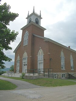
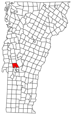
Pittsford, Vermont | |
---|---|
Coordinates: 43°42′N73°1′W / 43.700°N 73.017°W | |
Country | United States |
State | Vermont |
County | Rutland |
Area | |
• Total | 43.6 sq mi (112.8 km2) |
• Land | 43.5 sq mi (112.6 km2) |
• Water | 0.1 sq mi (0.2 km2) |
Elevation | 466 ft (142 m) |
Population (2020) | |
• Total | 2,862 |
• Density | 66/sq mi (25/km2) |
Time zone | UTC-5 (Eastern (EST)) |
• Summer (DST) | UTC-4 (EDT) |
ZIP code | 05763 |
Area code | 802 |
FIPS code | 50-55600 [1] |
GNIS feature ID | 1462174 [2] |
Pittsford is a town in Rutland County, Vermont, United States. As of the 2020 census, the town population was 2,862. [3] Named for William Pitt, it has two picket forts used in the American Revolutionary War.
Pittsford was first settled as a frontier town in 1769, about 60 miles (97 km) north of Bennington. It is the location of two historical picket forts used by the militia during the American Revolutionary War: Fort Mott (built in 1777), and Fort Vengeance (built from 1780 to 1781), about a mile north.
The town of Pittsford, New York, was named by Colonel Caleb Hopkins after his hometown of Pittsford, Vermont, named after William Pitt. [4]
Among the first settlers in Pittsford were the Cooley half-brothers, Benjamin Cooley III and Gideon Cooley. [5] Gideon Cooley and Benjamin Cooley III were members of the Green Mountain Boys, and Benjamin was Captain under Col. Ethan Allen in the Revolutionary War and specifically the Capture of Fort Ticonderoga. [6]
According to the United States Census Bureau, the town has a total area of 43.6 square miles (113 km2), of which 43.5 square miles (113 km2) is land and 0.1 square miles (0.26 km2), or 0.18%, is water. The unincorporated village of Pittsford is in the center of the town.
Census | Pop. | Note | %± |
---|---|---|---|
1790 | 850 | — | |
1800 | 1,413 | 66.2% | |
1810 | 1,936 | 37.0% | |
1820 | 1,916 | −1.0% | |
1830 | 2,005 | 4.6% | |
1840 | 1,927 | −3.9% | |
1850 | 2,026 | 5.1% | |
1860 | 1,839 | −9.2% | |
1870 | 2,127 | 15.7% | |
1880 | 1,982 | −6.8% | |
1890 | 1,775 | −10.4% | |
1900 | 1,866 | 5.1% | |
1910 | 2,479 | 32.9% | |
1920 | 2,098 | −15.4% | |
1930 | 2,332 | 11.2% | |
1940 | 2,093 | −10.2% | |
1950 | 2,076 | −0.8% | |
1960 | 2,225 | 7.2% | |
1970 | 2,306 | 3.6% | |
1980 | 2,590 | 12.3% | |
1990 | 2,919 | 12.7% | |
2000 | 3,140 | 7.6% | |
2010 | 2,991 | −4.7% | |
2020 | 2,862 | −4.3% | |
U.S. Decennial Census [7] |
As of the census [1] of 2000, there were 3,140 people, 1,284 households, and 876 families residing in the town. The population density was 72.2 people per square mile (27.9/km2). There were 1,388 housing units at an average density of 31.9 per square mile (12.3/km2). The racial makeup of the town was 99.08% White, 0.22% African American, 0.06% Native American, 0.19% Asian, and 0.45% from two or more races. Hispanic or Latino of any race were 0.41% of the population.
There were 1,284 households, out of which 29.7% had children under the age of 18 living with them, 56.2% were married couples living together, 8.3% had a female householder with no husband present, and 31.7% were non-families. 23.8% of all households were made up of individuals, and 9.3% had someone living alone who was 65 years of age or older. The average household size was 2.44 and the average family size was 2.88.
In the town, the population was spread out, with 23.2% under the age of 18, 6.1% from 18 to 24, 30.0% from 25 to 44, 27.6% from 45 to 64, and 13.2% who were 65 years of age or older. The median age was 40 years. For every 100 females, there were 99.9 males. For every 100 females age 18 and over, there were 93.7 males.
The median income for a household in the town was $40,027, and the median income for a family was $44,079. Males had a median income of $34,769 versus $24,342 for females. The per capita income for the town was $19,271. About 6.0% of families and 9.0% of the population were below the poverty line, including 9.4% of those under age 18 and 5.6% of those age 65 or over.
Rutland County is a county located in the U.S. state of Vermont. As of the 2020 census, the population was 60,572, making it the second-most populous county in Vermont. Its county seat and most populous municipality is the city of Rutland.
Gilead is a town in Oxford County, Maine, United States. Upon incorporation in 1804, it was named for the large quantity of Balm of Gilead trees in the town center. The population was 195 at the 2020 census.
Crown Point is a town in Essex County, New York, United States, located on the west shore of Lake Champlain. The population was 2,024 at the 2010 census. The name of the town is a direct translation of the original French name, Pointe à la Chevelure.
Hartford is a town centrally located in Washington County, New York, United States. It is part of the Glens Falls Metropolitan Statistical Area. The town population was 2,279 at the 2000 census.
Kirby is a town in Caledonia County, Vermont, United States. The population was 575 at the 2020 census.
Hinesburg is a town in Chittenden County, Vermont, United States. The town was named for Abel Hine, town clerk. The population was 4,698 at the 2020 census.
Bloomfield is a town in Essex County, Vermont, United States. The population was 217 at the 2020 census. It is part of the Berlin, NH–VT Micropolitan Statistical Area.
Lemington is a town in Essex County, Vermont, United States. The population was 87 as of the 2020 census. It is part of the Berlin, NH–VT Micropolitan Statistical Area.
Lunenburg is a town in Essex County, Vermont, United States. The population was 1,246 at the 2020 census, the most populous in Essex County. Lunenburg contains the villages of West Lunenburg, South Lunenburg, Mill Village and Gilman, and is part of the Berlin, NH–VT Micropolitan Statistical Area.
Maidstone is a town in Essex County, Vermont, United States. As of the 2020 census, the town had a population of 211. It is part of the Berlin, NH–VT Micropolitan Statistical Area. There is no town center or gas station, but there is a town office building in the southern part of the town.
North Hero is a town in and the shire town of Grand Isle County, Vermont, United States. The population was 939 at the 2020 census.
Wolcott is a town in Lamoille County, Vermont, United States. The town was named for General Oliver Wolcott, a signer of the Declaration of Independence. The population was 1,670 at the 2020 census.
Randolph is a town in Orange County, Vermont, United States. The population was 4,774 at the 2020 census, making Randolph the largest town in Orange County. The town is a commercial center for many of the smaller, rural farming communities that surround it.
Williamstown is a town in Orange County, Vermont, United States. The population was 3,515 at the 2020 census, making it the second largest municipality in the county.
Danby is a town in Rutland County, Vermont, United States. The population was 1,284 at the 2020 census.
Proctor is a town in Rutland County, Vermont, United States. The population was 1,763 at the 2020 census. Proctor is home to the Vermont Marble Museum and Wilson Castle.
West Haven is a town in Rutland County, Vermont, United States. The population was 239 at the 2020 census.
Andover is a town in Windsor County, Vermont, United States. The population was 568 at the 2020 census.
Reading is a town in Windsor County, Vermont, United States. The population was 687 at the 2020 census.
Ettrick is a town in Trempealeau County, Wisconsin. The population was 1,284 at the time of the 2000 census. The town surrounds the village of Ettrick. The unincorporated communities of Beaches Corners, Chapultepee, Hegg, Iduna, and Upper French Creek are also located in the town.