Falkland, North Carolina

Last updated

Falkland, North Carolina
Falkland, North Carolina.jpg
NCMap-doton-Falkland.PNG
Location of Falkland, North Carolina
Coordinates: 35°41′55″N77°30′46″W / 35.69861°N 77.51278°W / 35.69861; -77.51278
Country United States
State North Carolina
County Pitt
Area
[1]
  Total0.23 sq mi (0.59 km2)
  Land0.23 sq mi (0.59 km2)
  Water0.00 sq mi (0.00 km2)
Elevation
[2]
75 ft (23 m)
Population
 (2020)
  Total47
  Density206.14/sq mi (79.69/km2)
Time zone UTC-5 (Eastern (EST))
  Summer (DST) UTC-4 (EDT)
ZIP code
27827
Area code 252
FIPS code 37-22640 [3]
GNIS feature ID2406486 [2]

Falkland is a town in Pitt County, North Carolina, United States. The population was 96 at the 2010 census, making it the least populous town in Pitt County. The town is a part of the Greenville Metropolitan Area located in North Carolina's Inner Banks region.

Contents

History

The Falkland Historic District, Spencer Harris House, and Dupree-Moore Farm are listed on the National Register of Historic Places. [4] [5] [6]

Geography

According to the United States Census Bureau, the town has a total area of 0.2 square miles (0.52 km2), all land.

Demographics

Historical population
CensusPop.Note
1890 61
1900 139127.9%
1910 132−5.0%
1920 19850.0%
1930 187−5.6%
1940 1880.5%
1950 174−7.4%
1960 140−19.5%
1970 130−7.1%
1980 118−9.2%
1990 108−8.5%
2000 1123.7%
2010 96−14.3%
2020 47−51.0%
U.S. Decennial Census [7]

As of the census [3] of 2000, there were 112 people, 39 households, and 26 families residing in the town. The population density was 453.7 inhabitants per square mile (175.2/km2). There were 42 housing units at an average density of 170.2 per square mile (65.7/km2). The racial makeup of the town was 68.75% White, 30.36% African American, 0.89% from other races. Hispanic or Latino of any race were 9.82% of the population.

There were 39 households, out of which 20.5% had children under the age of 18 living with them, 35.9% were married couples living together, 20.5% had a female householder with no husband present, and 30.8% were non-families. 25.6% of all households were made up of individuals, and 15.4% had someone living alone who was 65 years of age or older. The average household size was 2.87 and the average family size was 3.37.

In the town, the population was spread out, with 22.3% under the age of 18, 8.0% from 18 to 24, 37.5% from 25 to 44, 17.0% from 45 to 64, and 15.2% who were 65 years of age or older. The median age was 35 years. For every 100 females, there were 77.8 males. For every 100 females age 18 and over, there were 81.3 males.

The median income for a household in the town was $31,250, and the median income for a family was $43,750. Males had a median income of $30,000 versus $14,107 for females. The per capita income for the town was $11,997. There were 5.0% of families and 19.8% of the population living below the poverty line, including 21.4% of under eighteens and 35.7% of those over 64.

Related Research Articles

<span class="mw-page-title-main">Pitt County, North Carolina</span> County in North Carolina, United States

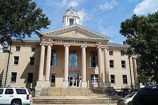
Pitt County is a county located in the Inner Banks region of the U.S. state of North Carolina. As of the 2020 census, the population was 170,243, making it the 14th-most populous county in North Carolina. Its county seat is Greenville.

<span class="mw-page-title-main">Mount Pleasant, North Carolina</span> Town in North Carolina, United States

Mount Pleasant is a town located in eastern Cabarrus County, North Carolina, United States. As of the 2010 census, the town population was 1,652. The town center is located at the crossroads of Mount Pleasant Road and North Carolina Highway 73. NC Highway 49 skirts the town to the north on its way from Charlotte to Asheboro.

<span class="mw-page-title-main">Mooresboro, North Carolina</span> Town in North Carolina, United States

Mooresboro is a town in Cleveland County, North Carolina, United States. The population was 311 at the 2010 census.

<span class="mw-page-title-main">Cooleemee, North Carolina</span> Town in North Carolina, United States

Cooleemee is a town in Davie County, North Carolina, United States. The population was 940 at the 2020 census.

<span class="mw-page-title-main">Conetoe, North Carolina</span> Town in North Carolina, United States

Conetoe is a 246-square-mile (640-square-kilometer) is a town in Edgecombe County, North Carolina, United States. It is part of the Rocky Mount, North Carolina Metropolitan Statistical Area. The population was 294 at the 2010 census.

<span class="mw-page-title-main">Pinetops, North Carolina</span> Town in North Carolina, United States

Pinetops is a town in Edgecombe County, North Carolina, United States. It is part of the Rocky Mount, North Carolina Metropolitan Statistical Area. The population was 1,374 at the 2010 census.

<span class="mw-page-title-main">Walstonburg, North Carolina</span> Town in North Carolina, United States

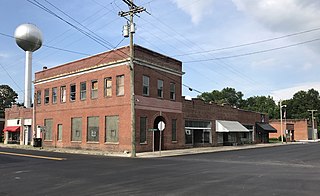
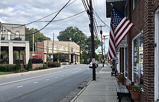
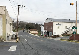
Walstonburg is a town in Greene County, North Carolina, United States. The population was 219 at the 2010 census. It is located north of Snow Hill on North Carolina Highway 91. The town is part of the Greenville Metropolitan Area.

<span class="mw-page-title-main">Trenton, North Carolina</span> Town in North Carolina, United States

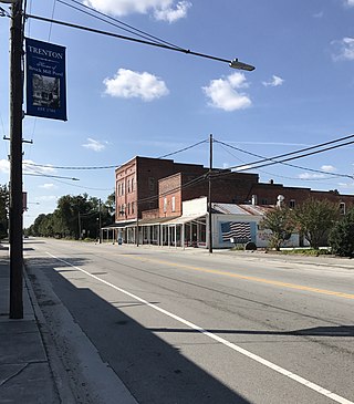
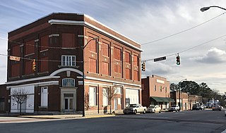
Trenton is a town in Jones County, North Carolina, United States. The population was 238 in 2020 census. It is the county seat of Jones County.

<span class="mw-page-title-main">Red Oak, North Carolina</span> Town in North Carolina, United States

Red Oak is a town in Nash County, North Carolina, United States. It is part of the Rocky Mount, North Carolina Metropolitan Statistical Area. The population was 3,430 in 2010.

<span class="mw-page-title-main">Burgaw, North Carolina</span> Town in North Carolina, United States

Burgaw is a town in, and the county seat of, Pender County, North Carolina, United States. The population was 3,088 at the 2020 census.

<span class="mw-page-title-main">Ayden, North Carolina</span> Town in North Carolina, United States

Ayden is a town in Pitt County, North Carolina, United States. The population was 4,977 at the 2020 census. The town is a part of the Greenville Metropolitan Area of North Carolina's Inner Banks region.

<span class="mw-page-title-main">Fountain, North Carolina</span> Town in North Carolina, United States

Fountain is a town in Pitt County, North Carolina, United States. The population was 427 at the 2010 census. The town is a part of the Greenville Metropolitan Area located in North Carolina's Inner Banks region.

<span class="mw-page-title-main">Grimesland, North Carolina</span> Town in North Carolina, United States

Grimesland is a town in Pitt County, North Carolina, United States. The population was 441 at the 2010 census. The town is a part of the Greenville Metropolitan Area located in North Carolina's Inner Banks.

<span class="mw-page-title-main">Winterville, North Carolina</span> Town in North Carolina, United States

Winterville is a town in Pitt County, North Carolina, United States. The population was 10,591 as of the 2020 census. The town is a part of the Greenville Metropolitan Area.

<span class="mw-page-title-main">Columbus, North Carolina</span> Town in North Carolina, United States

Columbus is a town and the county seat of Polk County, North Carolina, United States. The population was 999 at the 2010 census.

<span class="mw-page-title-main">Franklinville, North Carolina</span> Town in North Carolina, United States

Franklinville is a town in Randolph County, North Carolina, United States. The population was 1,164 at the 2010 census.

<span class="mw-page-title-main">Staley, North Carolina</span> Town in North Carolina, United States

Staley is a town in Randolph County, North Carolina, United States. The population was 393 at the 2010 census.

<span class="mw-page-title-main">Proctorville, North Carolina</span> Town in North Carolina, United States

Proctorville is a town in Robeson County, North Carolina, United States. The population was 117 at the 2010 census.

<span class="mw-page-title-main">Jonesville, South Carolina</span> City in South Carolina, United States

Jonesville is a town in Union County, South Carolina, United States. The population was 911 at the 2010 United States Census.

<span class="mw-page-title-main">Smyrna, South Carolina</span> Town in South Carolina, United States

Smyrna is a small town in York and Cherokee counties in the U.S. state of South Carolina. The population was 45 at the 2010 United States Census,..

References

  1. "ArcGIS REST Services Directory". United States Census Bureau. Retrieved September 20, 2022.
  2. 1 2 U.S. Geological Survey Geographic Names Information System: Falkland, North Carolina
  3. 1 2 "U.S. Census website". United States Census Bureau . Retrieved January 31, 2008.
  4. "National Register Information System". National Register of Historic Places . National Park Service. July 9, 2010.
  5. "National Register of Historic Places Listings". Weekly List of Actions Taken on Properties: 8/27/12 through 8/31/12. National Park Service. September 7, 2012.
  6. "National Register of Historic Places Listings". Weekly List of Actions Taken on Properties. National Park Service. October 12, 2012.
  7. "Census of Population and Housing". Census.gov. Retrieved June 4, 2015.