Farallon Island Light

Last updated
Farallon Island Light
Farallonlths.jpg
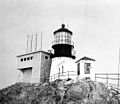
Historic photo of Farallon Island Light, with mule (USCG)
Farallon Island Light
Location Farallon Island
California
United States
Coordinates 37°41′56″N123°00′06″W / 37.698966°N 123.001651°W / 37.698966; -123.001651 Coordinates: 37°41′56″N123°00′06″W / 37.698966°N 123.001651°W / 37.698966; -123.001651
Tower
Constructed1855
Foundationbrick basement
Constructionbrick tower
Automated1972
Height41 feet (12 m)
Shapetapered cylindrical tower with balcony and lantern removed
Markingswhite tower
OperatorFarallon National Wildlife Refuge [1] [2]
Light
Focal height358 feet (109 m)
LensFirst order Fresnel lens (original), Vega VRB aerobeacon (current)
Range14 nmi (26 km; 16 mi)  OOjs UI icon edit-ltr-progressive.svg
Characteristic Fl W 15s.

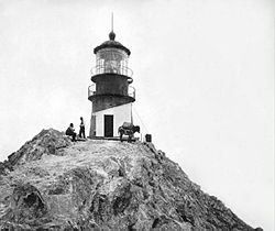
Farallon Island Light is a lighthouse on Southeast Farallon Island, California. One of the highest lights in California, it was constructed in 1855 to warn ships approaching San Francisco from the west away from the rocky islands. In later years it was shorn of its lantern, but it remains in use.

Contents

History

Farallon Island Light was constructed on Southeast Farallon Island. After the tower was complete, it proved too small to house a first-order Fresnel lens, and the tower had to be torn down and rebuilt. The lighthouse was lit for the first time in December 1855. In 1939, the United States Coast Guard took over the lighthouse when the United States Lighthouse Service merged with it. The Coast Guard maintained a presence until 1972. By that time, the lantern room and the Fresnel lens had been removed, and an automated aero beacon was placed on the tower. The lens is on display in the San Francisco Maritime National Historic Park visitor center on Hyde Street, while the lantern room itself was scrapped after removal.

From Coast Guard web site:

This lighthouse is situated on the highest peak of the southeast Farallon. It was built in 1855 in the busy days which followed the gold rush when clipper ships and other sailing vessels were sailing in to San Francisco in large numbers. That there was need for a light on these dangerous rocks is evident when clippers like the Golden City which sailed from New York in 1852 reported that she was detained 5 days off the Farallons in fog. Stone for the construction of the lighthouse was quarried on the island and inside this masonry was a lining of brick. The extremely sharp slopes of the island and the jagged nature of the rock were serious obstacles to construction work. The bricks used in the tower were carried up the rock in bundles of four and five on the backs of men. After the completion of the tower a mule was kept on the island for years to carry supplies between the various parts of the station. At one time this mule was the oldest inhabitant. A number of years ago the gathering of birds’ eggs, which were sold on the San Francisco market, was carried on here extensively and seals were also hunted commercially. These practices were finally terminated by the Federal Government. The Farallon Light Station was equipped with a radiobeacon as well as with a powerful light and fog signal. [3]

See also

Related Research Articles

<span class="mw-page-title-main">Point Pinos Lighthouse</span> 19th century lighthouse in Pacific Grove, California

Point Pinos Lighthouse was lit on February 1, 1855, to guide ships on the Pacific Coast of California. It is the oldest continuously operating lighthouse on the West Coast of the United States and even the lens is original. Alcatraz Island Lighthouse preceded Point Pinos by eight months, but was replaced in 1909 by the expanding military prison. The Point Pinos Lighthouse is still an active United States Coast Guard aid to navigation. On-site museum exhibits and other lighthouse related functions are operated by the city of Pacific Grove, Monterey County, California. The lighthouse is surrounded by the Pacific Grove Municipal Golf Links.

<span class="mw-page-title-main">East Brother Island Light</span> Lighthouse in California, United States

East Brother Island Lighthouse is a lighthouse located on East Brother Island in San Rafael Bay, near the tip of Point San Pablo in Richmond, California. It marks the entrance to San Pablo Bay from San Francisco Bay.

<span class="mw-page-title-main">Old Point Loma Lighthouse</span> Lighthouse in California, United States

The original Point Loma Lighthouse is a historic lighthouse located on the Point Loma peninsula at the mouth of San Diego Bay in San Diego, California. It is situated in the Cabrillo National Monument. It is no longer in operation as a lighthouse but is open to the public as a museum. It is sometimes erroneously called the "Old Spanish Lighthouse", but in fact it was not built during San Diego's Spanish or Mexican eras; it was built in 1855 by the United States government after California's admission as a state.

<span class="mw-page-title-main">Point Robinson Light</span> Lighthouse

The Point Robinson Light is an operational aid to navigation and historic lighthouse on Puget Sound, located at Point Robinson, the easternmost point of Maury Island, King County, in the U.S. state of Washington. The site was listed on the National Register of Historic Places in 2004.

<span class="mw-page-title-main">Tree Point Light</span> Lighthouse

The Tree Point Light is a lighthouse located adjacent to Revillagigedo Channel in Southeast Alaska, United States. It is located near the southernmost point of mainland Alaska.

<span class="mw-page-title-main">Alcatraz Island Lighthouse</span> Lighthouse in the San Francisco Bay, California

Alcatraz Island Lighthouse is a lighthouse—the first one built on the U.S. West Coast—located on Alcatraz Island in California's San Francisco Bay. It is located at the southern end of the island near the entrance to the prison. The first light house on the island was completed in 1854, and served the bay during its time as a Citadel and military prison. It was replaced by a taller concrete tower built in 1909 to the south of the original one which was demolished after it was damaged due to earthquake in 1906. The automation of the lighthouse with a modern beacon took place in 1963, the year Alcatraz closed as the Alcatraz Federal Penitentiary. It is the oldest light station on the island with a modern beacon and is part of the museum on the island. Although when viewed from afar it easily looks the tallest structure on Alcatraz, it is actually shorter than the Alcatraz Water Tower, but as it lies on higher ground it looks much taller.

<span class="mw-page-title-main">Point Reyes Lighthouse</span> Lighthouse in California, United States

The Point Reyes Lighthouse, also known as Point Reyes Light or the Point Reyes Light Station, is a lighthouse in the Gulf of the Farallones on Point Reyes in Point Reyes National Seashore, located in Marin County, California, United States.

<span class="mw-page-title-main">Yerba Buena Light</span> Lighthouse in the San Francisco Bay, California

Yerba Buena Lighthouse is a lighthouse in California, United States, in the San Francisco Bay on Yerba Buena Island, California

<span class="mw-page-title-main">Carquinez Strait Light</span> Lighthouse in California, United States

Carquinez Strait Lighthouse is a lighthouse in California, United States. It was originally approximately 20 miles inland from the mouth of the San Francisco Bay near Vallejo, California.

<span class="mw-page-title-main">Fort Point Light (San Francisco)</span> Lighthouse in California, United States

Fort Point Light is a decommissioned lighthouse built on the third tier of Fort Point, which is now directly beneath the south anchorage of the Golden Gate Bridge in San Francisco, California. The lighthouse is at the south end of the narrowest part of Golden Gate strait. It was preceded by two other lighthouses in nearby locations. The present lighthouse was in operation from 1864 until 1934.

<span class="mw-page-title-main">Ballast Point Lighthouse</span> Lighthouse in California, United States

Ballast Point Lighthouse was a lighthouse in California, situated on Ballast Point, a tiny peninsula extending into San Diego Bay from Point Loma, San Diego, California. The lighthouse was torn down in 1960; the site is now on the grounds of Naval Base Point Loma. Ballast Point Lighthouse was the last lighthouse displaying a fixed light on the Pacific Coast. An automated light is left in its place and operates on a piling in the water off of the original site.

<span class="mw-page-title-main">Point Arena Light</span> Lighthouse in California, United States

Point Arena Light is a lighthouse in Mendocino County, California, United States, two miles (3 km) north of Point Arena, California. It is approximately 130 mi (210 km) north of San Francisco, in the Fort Point Group of lighthouses. The lighthouse features a small museum and gift shop. Guided tours of the light station as well as self-guided tours of the grounds are available daily.

<span class="mw-page-title-main">Point Montara Light</span> Lighthouse in California, United States

The Point Montara Light is a lighthouse in Montara, California, United States, on the southern approach to the San Francisco Bay, California approximately 25 miles south of San Francisco.

<span class="mw-page-title-main">Table Bluff Light</span> Lighthouse in California, United States

Table Bluff Lighthouse is a lighthouse in California, United States, which was located on Table Bluff just south of Humboldt Bay. Built to guide vessels away from the notoriously dangerous and rough coastline and to let them know proximity of the nearby bay and entrance, the lighthouse was one of the first to be automated. The lighthouse tower portion is now located at the Woodley Island Marina within the City of Eureka.

<span class="mw-page-title-main">Manitou Island Light Station</span> Lighthouse in Michigan, United States

The Manitou Island Light Station is a lighthouse located on Manitou Island, off the tip of Michigan's Keweenaw Peninsula in Lake Superior. It was listed on the National Register of Historic Places in 1984.

<span class="mw-page-title-main">Point Sur Lighthouse</span> Lighthouse in California, United States

Point Sur Lighthouse is a lightstation at Point Sur 24.6 miles (39.6 km) south of Monterey, California at the peak of the 361-foot (110 m) rock at the head of the point. It was established in 1889 and is part of Point Sur State Historic Park. The light house is 40 feet (12 m) tall and 270 feet (82 m) above sea level. As of 2016, and for the foreseeable future the light is still in operation as an essential aid to navigation. Point Sur is the only complete turn-of-the-20th-century lightstation open to the public in California. Three-hour walking tours guided by volunteers are available on Wednesdays and weekends throughout the year.

<span class="mw-page-title-main">Fort Point Light (Maine)</span> Lighthouse in Maine, US

The Fort Point Light, or Fort Point Light Station, is located in Fort Point State Park, in Stockton Springs, Maine. A lighthouse at this point has served as an active aid to navigation since 1835; the present lighthouse dates to 1857, and is listed on the National Register of Historic Places.

<span class="mw-page-title-main">Egg Rock Light (Maine)</span> Lighthouse in Maine, US

Egg Rock Light is a lighthouse on Frenchman Bay, Maine. Built in 1875, it is one of coastal Maine's architecturally unique lighthouses, with a square tower projecting through the square keeper's house. Located on Egg Rock, midway between Mount Desert Island and the Schoodic Peninsula, it is an active aid to navigation, flashing red every 40 seconds. The light was listed on the National Register of Historic Places as Egg Rock Light Station in 1988.

<span class="mw-page-title-main">Pigeon Point Lighthouse</span> Historic lighthouse in California, United States

Pigeon Point Light Station or Pigeon Point Lighthouse is a lighthouse built in 1871 to guide ships on the Pacific coast of California. It is the tallest lighthouse on the West Coast of the United States. It is still an active Coast Guard aid to navigation. Pigeon Point Light Station is located on the coastal highway, 5 miles (8 km) south of Pescadero, California, between Santa Cruz and San Francisco. The 115-foot (35 m), white masonry tower, resembles the typical New England structure.

<span class="mw-page-title-main">Thunder Bay Island Light</span> Lighthouse in Michigan, United States

Thunder Bay Island Light, located on Thunder Bay Island's southeast tip, is one of the oldest operating lighthouses in Michigan. The third operating U.S. lighthouse in Lake Huron was built here in 1831, but it disintegrated almost at once and was rebuilt in 1832 of local limestone. This 40-foot (12 m) 1830s light tower was raised 10 feet (3.0 m)) to a height of 50 feet (15 m) in 1857, and sheathed with brick. A fourth order Fresnel lens was installed. This 1857 light tower is the current Thunder Bay Island Light, although the tower has been further altered and is currently 63 feet (19 m) high.

References

  1. Rowlett, Russ. "Lighthouses of the United States: Northern California". The Lighthouse Directory. University of North Carolina at Chapel Hill . Retrieved 2016-06-10.
  2. California Historic Light Station Information & Photography United States Coast Guard. Retrieved 10 June 2016
  3. "Historic Light Station Information and Photography: California". United States Coast Guard Historian's Office. Archived from the original on 2017-05-01. Retrieved 2008-08-23.