List of lighthouses in California

Last updated

There are several lighthouses in the U.S. state of California, including a few listed on the National Register of Historic Places.

Contents

Lighthouse Friends (California)

NameImageLocationCoordinatesYear first litAutomatedYear deactivatedCurrent LensFocal Height
Alcatraz Island Light Alcatraz lighthouse.jpg San Francisco
(Alcatraz Island)
37°49′34.5″N122°25′19.8″W / 37.826250°N 122.422167°W / 37.826250; -122.422167 1854 (First)
1909 (Current)
1963Active DCB-24 214 ft (65 m)
Anacapa Island Light Anacapa-lighthouse.jpg Anacapa Island 34°00′57″N119°21′34″W / 34.015827°N 119.359548°W / 34.015827; -119.359548 1912 (First)
1932 (Current)
1967 [1] ActiveDCB-24277 ft (84 m)
Ano Nuevo Light Ano Nuevo Lighthouse.JPG Año Nuevo Island 37°06′30″N122°20′16″W / 37.1083°N 122.3378°W / 37.1083; -122.3378
(Island coordinates)
1890 (First)
1914 (Last)
Never1948
(Cut down in 1976)
NoneUn­known
Ballast Point Light USCGballastpoint.JPG San Diego
(Point Loma)
32°41′11.0″N117°13′57.0″W / 32.686389°N 117.232500°W / 32.686389; -117.232500 1890Never1960 A
(Demolished)
NoneUn­known
Battery Point Light Battery Point Lighthouse, Crescent City.jpg Crescent City 41°44′39″N124°12′11″W / 41.744094°N 124.203099°W / 41.744094; -124.203099 18561953Active
(Inactive: 1965–1982)
375mm77 ft (23 m)
Cape Mendocino Light Cape Mendocino Lighthouse in Shelter Cove.jpg Shelter Cove 40°26′23.66″N124°24′21.71″W / 40.4399056°N 124.4060306°W / 40.4399056; -124.4060306 186819511971 B
(Replaced)
None422 ft (129 m)
Carquinez Strait Light Carquinez Strait Light.jpg Vallejo 38°04′04″N122°12′50″W / 38.067816°N 122.213832°W / 38.067816; -122.213832 1910Never1951
(Replaced by beacon)
None56 ft (17 m)
East Brother Island Light East Brother Light (front view).jpg Richmond 37°57′48″N122°26′01″W / 37.963233°N 122.433643°W / 37.963233; -122.433643 18741969ActiveFA 25161 ft (19 m)
Farallon Island Light Farallonlight.jpg San Francisco
(Farallon Islands)
37°41′56″N123°00′06″W / 37.698966°N 123.001651°W / 37.698966; -123.001651 18561972Active VRB-25 358 ft (109 m)
Fort Point Light Fort Point Light, San Francisco (2013).jpg San Francisco 37°48′38″N122°28′38.4″W / 37.81056°N 122.477333°W / 37.81056; -122.477333 1855 (First)
1864 (Current)
Never1934
(Replaced by bridge)
None110 ft (34 m)
Humboldt Harbor Light Eureka
(Humboldt Bay)
40°46′7.1″N124°13′15.7″W / 40.768639°N 124.221028°W / 40.768639; -124.221028 1856Never1892
(Collapsed in 1933)
None45 ft (14 m)
Lime Point Light Lime Point Light Station beneath the Golden Gate Bridge.jpg San Francisco 37°49′32″N122°28′42″W / 37.825447°N 122.478321°W / 37.825447; -122.478321 19001961ActiveNone20 ft (6.1 m)
Lions Lighthouse for Sight Lion's Lighthouse - Long Beach, CA (24920590396).jpg Long Beach 33°45′37″N118°11′39″W / 33.7602334°N 118.1941101°W / 33.7602334; -118.1941101 2000 [2] Un­knownUn­knownUn­known65.62 ft (20.00 m) [2]
Long Beach Light USCGlongbeachRobot.JPG Long Beach
(Port of Long Beach)
33°43′24″N118°11′13″W / 33.723237°N 118.186821°W / 33.723237; -118.186821 1949AlwaysActiveUn­known50 ft (15 m)
Los Angeles Harbor Light Angels Gate light crop.jpg Los Angeles
(Port of Los Angeles)
33°42′31″N118°15′06″W / 33.70857°N 118.25160°W / 33.70857; -118.25160 19131973ActiveDCB-2473 ft (22 m)
Mare Island Light USCGmareisland nodate 3 300.jpg Vallejo
(Mare Island)
38°04′29″N122°15′02″W / 38.074834°N 122.250464°W / 38.074834; -122.250464 1873Never1917
(Demolished in the 1930s)
None76 ft (23 m)
Mile Rocks Light 2017 Mile Rocks Lighthouse.jpg San Francisco 37°47′34″N122°30′37″W / 37.792765°N 122.510366°W / 37.792765; -122.510366 19061966ActiveDCB-2449 ft (15 m)
Oakland Harbor Light USCGoaklandharbor.JPG Oakland 37°46′53″N122°14′38″W / 37.781335°N 122.243817°W / 37.781335; -122.243817 1890 (First)
1903 (Last)
Never1966 C NoneUn­known
Parkers' Lighthouse Long Beach 33°45′36″N118°11′31″W / 33.7598744°N 118.1920629°W / 33.7598744; -118.1920629 Un­knownUn­knownUn­knownUn­knownUn­known
Piedras Blancas Light Piedras Blancas Lighthouse (01).jpg San Simeon 35°39′56.3″N121°17′03.6″W / 35.665639°N 121.284333°W / 35.665639; -121.284333 18751975ActiveVRB-25142 ft (43 m)
Pigeon Point Light LighthousePigeonPointCA.jpg Half Moon Bay 37°10′54.3″N122°23′38.1″W / 37.181750°N 122.393917°W / 37.181750; -122.393917 18721974ActiveDCB-24148 ft (45 m)
Point Arena Light Point Arena Lighthouse.jpg Point Arena 38°57′17.1″N123°44′25.8″W / 38.954750°N 123.740500°W / 38.954750; -123.740500 1870 (First)
1908 (Current)
1977Active DCB-224 155 ft (47 m)
Point Arguello Light USCGpointarguellooriginal.JPG Lompoc
(Point Arguello)
34°34′37.4″N120°38′49.9″W / 34.577056°N 120.647194°W / 34.577056; -120.647194 1901 (First)
1934 (Last)
19341967 D None124 ft (38 m)
Point Blunt Light USCGpointblunt.JPG San Francisco
(Angel Island)
37°51′11.64″N122°25′9.25″W / 37.8532333°N 122.4192361°W / 37.8532333; -122.4192361 1915 (First)
1956 (Current)
1976ActiveUn­known60 ft (18 m)
Point Bonita Light Point Bonita Lighthouse on the Marin Headlands.jpg San Francisco
(Point Bonita)
37°48′56″N122°31′46″W / 37.815614°N 122.529578°W / 37.815614; -122.529578 1855 (First)
1877 (Current)
1980ActiveSecond-order Fresnel 124 ft (38 m)
Point Cabrillo Light Point Cabrillo Lighthouse, on an early morning in February.jpg Caspar 39°20′54.97″N123°49′34.02″W / 39.3486028°N 123.8261167°W / 39.3486028; -123.8261167 19091973ActiveThird-order Fresnel81 ft (25 m)
Point Conception Light Aerial-PtConceptionLightClose.jpg Lompoc
(Point Conception)
34°26′55.51″N120°28′14.71″W / 34.4487528°N 120.4707528°W / 34.4487528; -120.4707528 1856 (First)
1882 (Current)
1973ActiveVRB-25133 ft (41 m)
Point Diablo Light Point Diablo Light, California.jpg San Francisco
(Golden Gate)
37°49′13″N122°29′58″W / 37.820171°N 122.499423°W / 37.820171; -122.499423 1923AlwaysActiveUn­knownUn­known
Point Fermin Light Pointfermin.jpg Los Angeles
(San Pedro)
33°42′20″N118°17′37″W / 33.705420°N 118.293649°W / 33.705420; -118.293649 1874Never1942None120 ft (37 m)
Point Hueneme Light Point Hueneme Lighthouse.jpg Port Hueneme 34°08′43″N119°12′36″W / 34.145176°N 119.210019°W / 34.145176; -119.210019 1874 (First)
1941 (Current)
1972ActiveLED52 ft (16 m)
Point Knox Light San Francisco 1900Un­known1963
(Demolished)
NoneUn­known
Point Loma Light (old) Old Point Loma lighthouse 11.JPG San Diego
(Point Loma)
32°40′19″N117°14′27″W / 32.671983°N 117.240938°W / 32.671983; -117.240938 1855 E Never1891Third-order Fresnel
(Deactivated)
462 ft (141 m)
Point Loma Light (new) Point Loma Lighthouse.jpg San Diego
(Point Loma)
32°39′54″N117°14′33″W / 32.665071°N 117.242621°W / 32.665071; -117.242621 18911973Active VLB-44 88 ft (27 m)
Point Montara Light Point Montara Light (2013).jpg Montara 37°32′11″N122°31′10″W / 37.536503°N 122.519311°W / 37.536503; -122.519311 1900 (First)
1928 (Current)
1970ActiveFA 25170 ft (21 m)
Point Pinos Light Point Pinos Light during reconstruction (2013).jpg Pacific Grove 36°38′00″N121°56′02″W / 36.633389°N 121.933783°W / 36.633389; -121.933783 18551975ActiveThird-order Fresnel89 ft (27 m)
Point Reyes Light Point Reyes Lighthouse in December 2019.jpg Point Reyes Station
(Point Reyes)
37°59′44″N123°01′24″W / 37.995621°N 123.023215°W / 37.995621; -123.023215 18701975ActiveFirst-order Fresnel265 ft (81 m)
Point San Luis Light San Luis Obispo Lighthouse, Aerial View 03-2016.jpg Avila Beach 35°09′37″N120°45′39″W / 35.160362°N 120.760882°W / 35.160362; -120.760882 189019741975 D None116 ft (35 m)
Point Sur Light Point Sur Light Station - lantern room from above.jpg Carmel-by-the-Sea 36°18′22.79″N121°54′05.36″W / 36.3063306°N 121.9014889°W / 36.3063306; -121.9014889 18891972ActiveDCB-224270 ft (82 m)
Point Vicente Light Parlos Verdes Light House Aug 2012.JPG Rancho Palos Verdes 33°44′31″N118°24′39″W / 33.741867°N 118.410738°W / 33.741867; -118.410738 19261973ActiveThird-order Fresnel155 ft (47 m)
Punta Gorda Light Punta Gorda Lighthouse - panoramio.jpg Petrolia 40°14′58″N124°21′01″W / 40.249433°N 124.350220°W / 40.249433; -124.350220 1912Never1951NoneUn­known
Roe Island Light USCGroeisland 1924a 300.jpg Roe Island 38°04′04″N122°01′41″W / 38.067856°N 122.028166°W / 38.067856; -122.028166 1891Never1945
(Later destroyed)
None41 ft (12 m)
Rubicon Point Light Rubicon Point Lighthouse 01.jpg South Lake Tahoe 38°59′45″N120°05′41″W / 38.99583°N 120.09472°W / 38.99583; -120.09472 1919Never1921None200 ft (61 m)
Santa Barbara Light SANTA BARBARA LIGHTHOUSE, CA.jpg Santa Barbara 34°23′47″N119°43′21″W / 34.396320°N 119.722625°W / 34.396320; -119.722625 1856 (First)
1928 (Current)
1928ActiveUn­known142 ft (43 m)
Santa Cruz Light IMG 9846Santa Cruz Lighthouse.jpg Santa Cruz 36°57′05.34″N122°01′36.36″W / 36.9514833°N 122.0267667°W / 36.9514833; -122.0267667 1870 (First)
1967 (Current)
1941Active?Un­known60 ft (18 m)
Santa Cruz Breakwater Light Walton Light.jpg Santa Cruz
(Santa Cruz harbor)
36°57′38.5″N122°00′08.0″W / 36.960694°N 122.002222°W / 36.960694; -122.002222 1964 (First)
2002 (Current)
AlwaysActiveUn­known60 ft (18 m)
Southampton Shoal Light Southampton Shoals LS.JPG San Francisco Bay 37°52′54.981″N122°24′00.837″W / 37.88193917°N 122.40023250°W / 37.88193917; -122.40023250 1905Never1960
(Moved to yacht club)
NoneUn­known
St. George Reef Light Stgeorgereef.jpg Crescent City 41°50′11″N124°22′33″W / 41.83633°N 124.37587°W / 41.83633; -124.37587 1892NeverActive
(Inactive: 1975–2012)
Un­known146 ft (45 m)
Sugar Pine Point Light Tahoma 39°03′41″N120°06′50″W / 39.061266°N 120.113971°W / 39.061266; -120.113971 1921Never1985 D NoneUn­known
Table Bluff Light Table Bluff Light, Woodley Island Marina.jpg Table Bluff 40°41′45.02″N124°16′26.16″W / 40.6958389°N 124.2739333°W / 40.6958389; -124.2739333 189219531971NoneUn­known
Trinidad Head Light Trinidad Memorial Lighthouse in Trinidad, California LCCN2013632280.tif Trinidad 41°3′7.0″N124°9′5.2″W / 41.051944°N 124.151444°W / 41.051944; -124.151444 18711974Active375mm196 ft (60 m)
Yerba Buena Light USCGyerbabuena2007rosen.jpg San Francisco
Yerba Buena Island
37°48′26.27″N122°21′44.29″W / 37.8072972°N 122.3623028°W / 37.8072972; -122.3623028 18751958ActiveUn­known95 ft (29 m)

Notable Faux Lighthouse

NameImageLocationYear builtStatusLens usedHeight
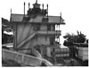
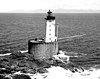
Passamaquoddy Lighthouse
(Used in the 1977 movie Pete's Dragon)
Los Osos [3] 1976torn down after filming [4] Fresnel Lens
(Replica)
52 ft (16 m)

Notes

A. ^ Ballast Point Light was moved in 1960 to the bell tower which had served as a fog signal building as the 1890 tower had been declared unsafe. The light shone from the top of the bell tower until 1961 when it was replaced by an offshore light.
B. ^ The tower was abandoned in 1971 when the beacon was moved to a nearby modern pole. This light was discontinued in 2013 fifteen years after the old tower was moved to a new spot and restored.
C. ^ Parts of the old structure now have separate owners, today an automated beacon is in active service.
D. ^ Light moved to a pole.
E. ^ Old Point Loma Light was built a few months after the lighthouse at Point Pinos making it the second oldest in the state still standing.

Related Research Articles

<i>Petes Dragon</i> (1977 film) 1977 American musical fantasy comedy by Don Chaffey

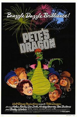
Pete's Dragon is a 1977 American live-action/animated musical fantasy film directed by Don Chaffey, produced by Jerome Courtland and Ron Miller, and written by Malcolm Marmorstein. Based on the unpublished short story "Pete's Dragon and the USA " by Seton I. Miller and S. S. Field, the film stars Sean Marshall, Helen Reddy, Jim Dale, Mickey Rooney, Red Buttons, Jeff Conaway, Shelley Winters, and the voice of Charlie Callas as Elliott.

<span class="mw-page-title-main">Cape Hatteras Lighthouse</span> Lighthouse in North Carolina, United States

Cape Hatteras Light is a lighthouse located on Hatteras Island in the Outer Banks in the town of Buxton, North Carolina and is part of the Cape Hatteras National Seashore. The lighthouse's semi-unique pattern makes it easy to recognize and famous. It is often ranked high on lists of most beautiful, and famous lighthouses in the US.

<span class="mw-page-title-main">Hereford Inlet Lighthouse</span> Lighthouse

The Hereford Inlet Lighthouse is a historic lighthouse located in North Wildwood, New Jersey, situated on the southern shore of Hereford Inlet at the north end of Five Mile Beach. Its construction was completed and it became operational in 1874.

<span class="mw-page-title-main">Bald Head Light</span> Lighthouse in North Carolina, US

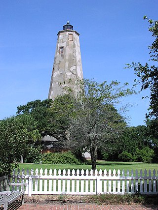
Bald Head Lighthouse, known as Old Baldy, is the oldest lighthouse still standing in North Carolina. It is the second of three lighthouses that have been built on Bald Head Island since the 18th century to help guide ships past the dangerous shoals at the mouth of the Cape Fear river.

<span class="mw-page-title-main">Wood Island Light</span> Lighthouse in Maine, US

Wood Island Light is an active lighthouse on the eastern edge of Wood Island in Saco Bay, on the southern coast of Maine. The light is just outside the entrance to Biddeford Pool and the end of the Saco River. The lighthouse is a 47-foot (14 m) conical white tower of granite rubble. The light itself sits 71 feet (22 m) above mean high water. Its automated beacon alternates between green and white every 10 seconds.

<span class="mw-page-title-main">St. George Reef Light</span> Lighthouse in California, United States

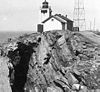
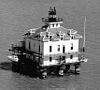
The St. George Reef Light is an inactive lighthouse built on North West Seal Rock, six miles (10 km) off the coast of northern California near Crescent City.

<span class="mw-page-title-main">St. Joseph Point Light</span> Lighthouse in Florida, US

The St. Joseph Point Light was a lighthouse on the mainland north of present-day Port St. Joe, Florida, across the entrance to St. Joseph Bay from St. Joseph Point. St. Joseph Bay is enclosed by St. Joseph Peninsula, which runs west some three miles (5 km) from the mainland to Cape San Blas, and then northerly 15 miles (24 km) to St. Joseph Point. An earlier light in the area was the St. Joseph Bay Light.

<span class="mw-page-title-main">Nauset Light</span> Lighthouse

Nauset Light, officially Nauset Beach Light, is a restored lighthouse on the Cape Cod National Seashore near Eastham, Massachusetts, erected in 1923 using the 1877 tower that was moved here from the Chatham Light. It is listed on the National Register of Historic Places. The tower is a cast-iron plate shell lined with brick and stands 48 feet (15 m) high. The adjacent oil house is made of brick and has also been restored. Fully automated, the beacon is a private aid to navigation. Tours of the tower and oil house are available in summer from the Nauset Light Preservation Society which operates, maintains and interprets the site. The tower is located adjacent to Nauset Light Beach.

<span class="mw-page-title-main">Old Point Loma Lighthouse</span> Lighthouse in California, United States

The original Point Loma Lighthouse is a historic lighthouse located on the Point Loma peninsula at the mouth of San Diego Bay in San Diego, California. It is situated in the Cabrillo National Monument. It is no longer in operation as a lighthouse but is open to the public as a museum. It is sometimes erroneously called the "Old Spanish Lighthouse", but in fact it was not built during San Diego's Spanish or Mexican eras; it was built in 1855 by the United States government after California's admission as a state.

<span class="mw-page-title-main">Point No Point Light (Washington)</span> Lighthouse in Washington, United States

Point No Point Light is an operational aid to navigation on the northeastern tip of the Kitsap Peninsula on the west side of Puget Sound, at Point No Point where Admiralty Inlet joins Puget Sound, near the small community of Hansville, Kitsap County, in the U.S. state of Washington. Point No Point Light is considered the oldest lighthouse on Puget Sound and is listed on the National Register of Historic Places.

<span class="mw-page-title-main">Alcatraz Island Lighthouse</span> Lighthouse in the San Francisco Bay, California

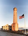
Alcatraz Island Lighthouse is a lighthouse—the first one built on the U.S. West Coast—located on Alcatraz Island in California's San Francisco Bay. It is located at the southern end of the island near the entrance to the prison. The first light house on the island was completed in 1854, and served the bay during its time as a Citadel and military prison. It was replaced by a taller concrete tower built in 1909 to the south of the original one which was demolished after it was damaged due to earthquake in 1906. The automation of the lighthouse with a modern beacon took place in 1963, the year Alcatraz closed as the Alcatraz Federal Penitentiary. It is the oldest light station on the island with a modern beacon and is part of the museum on the island. Although when viewed from afar it easily looks the tallest structure on Alcatraz, it is actually shorter than the Alcatraz Water Tower, but as it lies on higher ground it looks much taller.

<span class="mw-page-title-main">Point Arena Light</span> Lighthouse in California, United States

Point Arena Light is a lighthouse in Mendocino County, California, United States, two miles (3 km) north of Point Arena, California. It is approximately 130 mi (210 km) north of San Francisco, in the Fort Point Group of lighthouses. The lighthouse features a small museum and gift shop. Guided tours of the light station as well as self-guided tours of the grounds are available daily.

<span class="mw-page-title-main">Point Arguello Light</span> Lighthouse in California, United States

Point Arguello Lighthouse is a lighthouse on Point Arguello in Santa Barbara County, California, serving the Santa Barbara Channel on the Gaviota Coast adjoining Vandenberg Space Force Base near the city of Lompoc, California.

<span class="mw-page-title-main">Five Mile Point Light</span> Lighthouse in Connecticut, United States

Five Mile Point Light, also known as Five Mile Point Lighthouse or Old New Haven Harbor Lighthouse, is a U.S. lighthouse in Long Island Sound on the coast of New Haven, Connecticut. Located at the entrance to New Haven Harbor, the beacon's name derives from its proximity to Downtown New Haven, about five miles (8 km) away. The original lighthouse consisted of a 30-foot (9.1 m) octagonal wooden tower built in 1805 by Abisha Woodward. In 1847, a new 80-foot (24 m) octagonal tower was constructed by Marcus Bassett with East Haven brownstone. This new beacon was illuminated by 12 lamps with reflectors which were positioned 97 feet (30 m) above sea level. Also constructed at this time was a two-and-one-half story brick house which supplanted the previous, deteriorating keeper's dwelling. A fourth-order Fresnel lens replaced the lamps in 1855 and a fog bell was added in the 1860s. The Five Mile Point Light was deactivated in 1877 when the nearby Southwest Ledge Light was completed. Currently, the lighthouse is contained within Lighthouse Point Park and, along with the keeper's house, was listed on the National Register of Historic Places in 1990.

<span class="mw-page-title-main">Pointe aux Barques Light</span> Lighthouse in Michigan, United States

Pointe aux Barques Lighthouse is an active lighthouse located in Huron County in the U.S. state of Michigan. It is located along the shores of Lake Huron on the northeastern tip of the Thumb. Originally constructed in 1848, it is one of the oldest active lighthouses in the state. The name is translated as "point of little boats" from the French language, which refers to the shallow coastline that poses a threat to larger boats.

<span class="mw-page-title-main">Burnt Island Light</span> Lighthouse in Maine, United States

The Burnt Island Light, built in 1821, is the second oldest surviving lighthouse in Maine. It hosts a living history museum run by the state Department of Marine Resources. It was added to the National Register of Historic Places as Burnt Island Light Station on November 23, 1977.

<span class="mw-page-title-main">Rawley Point Light</span> Lighthouse

Rawley Point Light is a lighthouse located in Point Beach State Forest, near Two Rivers, Wisconsin. At 111 feet (34 m) tall, it is the tallest lighthouse on the Wisconsin Shore and it is listed on the National Register of Historic Places.

<span class="mw-page-title-main">St. Joseph North Pier Inner and Outer Lights</span> Lighthouse in Michigan, United States

The St. Joseph North Pier Inner and Outer Lights are lighthouses in Michigan at the entrance to the St. Joseph River on Lake Michigan. The station was built in 1832 with the current lights built in 1906 and 1907; they were decommissioned in 2005.

References

  1. "Anacapa Island Lighthouse". Lighthouse Friends. Retrieved October 8, 2017.
  2. 1 2 "The Lions Lighthouse for Sight, Long Beach | 1209333 | EMPORIS". Emporis. Archived from the original on July 16, 2018. Retrieved 16 July 2018.
  3. Pete's Dragon. Bonus Features: Film Facts (DVD). Disney Enterprises (distributed by Buena Vista Home Entertainment).
  4. Stacy Conradt (March 4, 2016). "12 Brazzle-Dazzle Facts About Pete's Dragon". Mental Floss. Retrieved October 9, 2017.