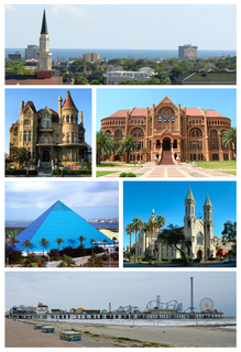
Galveston is a coastal resort city and port off the Southeast Texas coast on Galveston Island and Pelican Island in the U.S. state of Texas. The community of 209.3 square miles (542 km2), with a population of 47,743 in 2010, is the county seat of surrounding Galveston County and second-largest municipality in the county. It is also within the Houston–The Woodlands–Sugar Land metropolitan area at its southern end on the northwestern coast of the Gulf of Mexico.
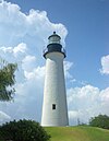
Port Aransas is a city in Nueces County, Texas, United States. This city is 180 miles southeast of San Antonio. The population was 2,904 at the 2020 census. Port Aransas is the only established town on Mustang Island. It is located north of Padre Island and is one of the longest barrier islands along the Texas coast. Corpus Christi Bay, the Gulf of Mexico, the Lydia Ann Ship Channel and the Corpus Christi Ship Channel make up the surrounding waters.
The 1900 Galveston hurricane, also known as the Great Galveston hurricane and the Galveston Flood, and known regionally as the Great Storm of 1900 or the 1900 Storm, was the deadliest natural disaster in United States history and the fifth-deadliest Atlantic hurricane, only behind Hurricane Mitch overall. The hurricane left between 6,000 and 12,000 fatalities in the United States; the number most cited in official reports is 8,000. Most of these deaths occurred in and near Galveston, Texas, after the storm surge inundated the coastline with 8 to 12 ft of water. In addition to the number killed, the storm destroyed about 7,000 buildings of all uses in Galveston, which included 3,636 demolished homes; every dwelling in the city suffered some degree of damage. The hurricane left approximately 10,000 people in the city homeless, out of a total population of fewer than 38,000. The disaster ended the Golden Era of Galveston, as the hurricane alarmed potential investors, who turned to Houston instead. In response to the storm, three engineers designed and oversaw plans to raise the Gulf of Mexico shoreline of Galveston Island by 17 ft (5.2 m) and erect a 10 mi (16 km) seawall.

Greater Houston, designated by the United States Office of Management and Budget as Houston–The Woodlands–Sugar Land, is the fifth-most populous metropolitan statistical area in the United States, encompassing nine counties along the Gulf Coast in Southeast Texas. With a population of 6,997,384 people at the 2018 census estimates and 7,122,240 in 2020, Greater Houston is the second-most populous in Texas after the Dallas–Fort Worth metroplex. The approximately 10,000-square-mile (26,000 km2) region centers on Harris County, the third-most populous county in the U.S., which contains the city of Houston—the largest economic and cultural center of the South—with a population of more than 2.3 million. Greater Houston is part of the Texas Triangle megaregion along with the Dallas–Fort Worth metroplex, Greater Austin, and Greater San Antonio. Greater Houston also serves as a major anchor and economic hub for the Gulf Coast. Its Port of Houston is the second largest port in the United States, sixteenth largest in the world, and leads the U.S. in international trade.

The Hereford Inlet Light is a historic lighthouse located in North Wildwood in Cape May County, New Jersey, United States, situated on the southwestern shore of Hereford Inlet at the north end of Five Mile Beach. Its construction was completed and it became operational in 1874.

The Sabine Pass Lighthouse, or Sabine Pass Light as it was referred to by the United States Coast Guard, is a historic lighthouse, as part of a gulf coast light station, on the Louisiana side of the Sabine River, in Cameron Parish, across from the community of Sabine Pass, Texas. It was first lit in 1857 and was deactivated by the Coast Guard in 1952. One of only three built in the United States of similar design, the light was listed on the National Register of Historic Places as "Sabine Pass Lighthouse" on December 17, 1981. It is now abandoned but has long continued to be the subject of preservation efforts.
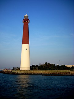
Barnegat Lighthouse or Barnegat Light, is a historic lighthouse located in Barnegat Lighthouse State Park on the northern tip of Long Beach Island, in the borough of Barnegat Light, Ocean County, New Jersey, United States, on the south side of Barnegat Inlet.
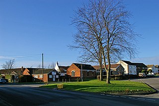
South Killingholme is a village and civil parish in North Lincolnshire, England. The population of the civil parish at the 2011 census was 1,108.

Stratford Shoal Light, officially Stratford Shoal Light, is a lighthouse on a shoal in the middle of Long Island Sound approximately halfway between Port Jefferson, New York and Bridgeport, Connecticut.
Fort Point Light was a lighthouse located on the south side of the entrance to Galveston Bay in Texas.
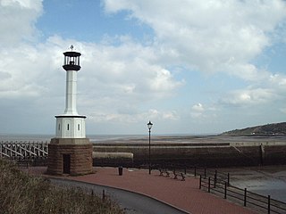
Maryport Lighthouse is a small lighthouse located in Maryport, Cumbria, England, formerly run by England's general lighthouse authority, Trinity House. It is a Grade II listed building.

West Dennis Light is a lighthouse in West Dennis, Massachusetts. It was previously known as Bass River Light. It is owned by and sits on top of the Lighthouse Inn, a seasonal hotel.
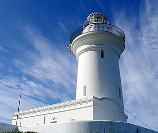
South Solitary Island Light is an active lighthouse on South Solitary Island, an island within the Solitary Islands Marine Park, about 15 kilometres (9.3 mi) northeast of Coffs Harbour, New South Wales, Australia. The lighthouse is located at the summit of the island. It is considered the most isolated lighthouse on the New South Wales coast. It was first in New South Wales to use kerosene over colza oil, and the last to do so before converting to electric power.

The Green Bay Harbor Entrance Light is an offshore lighthouse near Green Bay, Wisconsin. Located 10 miles (16 km) from the mouth of the Fox River, it was erected to signal the entrance to Green Bay.

The Christiana Light was a historic lighthouse located on the Christina River in Delaware. It was deactivated when new range lights came into service and was demolished in 1939.

The South Pass Light, also known as the Port Eads LighthouseSouth Point Light, or Gordon's Island Light, are a pair of lighthouses located on Gordon's Island at South Pass, in Plaquemines Parish, Louisiana (USA), one of the primary entrances to the Mississippi River Delta from the Gulf of Mexico. The light station was established in 1831 and is still active.

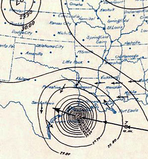
Racer's hurricane was a destructive tropical cyclone that had severe effects in northeastern Mexico, the Republic of Texas, and the Gulf Coast of the United States in early October 1837. It was named after the Royal Navy ship HMS Racer, which encountered the cyclone in the northwestern Caribbean. Termed "one of the most famous and destructive hurricanes of the century" by meteorology historian David Ludlum, the storm first affected Jamaica with flooding rainfall and strong winds on September 26 and 27, before entering the Gulf of Mexico by October 1. As the hurricane struck northern Tamaulipas and southern Texas, it slowed to a crawl and turned sharply northeastward. The storm battered the Gulf Coast from Texas to the Florida Panhandle between October 3 and 7. After crossing the Southeastern United States, it emerged into the Atlantic shipping lanes off the Carolinas by October 9.
USCGC Acacia (WAGL-200) was originally built for service by the U.S. Army as a mine planter shortly after World War I and later transferred to the U.S. Lighthouse Service, which became part of the U.S. Coast Guard in 1939; when transferred the ship was redesignated as a Speedwell-class buoy tender. She was sunk in 1942 by a German U-boat.