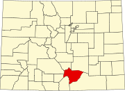
Huerfano County is a county located in the U.S. state of Colorado. As of the 2020 census, the population was 6,820. The county seat is Walsenburg. The county, whose name comes from the Spanish huérfano meaning "orphan", was named for the Huerfano Butte, a local landmark. The area of Huerfano County boomed early in the 1900s with the discovery of large coal deposits. After large scale World War II coal demand ended in the 1940s Walsenburg and Huerfano saw a steady economic decline through 2015.

Gunbarrel is an unincorporated community and a census-designated place (CDP) located in and governed by Boulder County, Colorado, United States. The CDP is a part of the Boulder, CO Metropolitan Statistical Area. The population of the Gunbarrel CDP was 9,554 at the United States Census 2020. The Boulder and Longmont post offices serve the area.

Blanca is a Statutory Town located in Costilla County, Colorado, United States. The town population was 322 at the 2020 census. Blanca is located in the enormous San Luis Valley.
The Air Force Academy is a census-designated place (CDP) located in El Paso County, Colorado, United States. The CDP includes the developed portion of the United States Air Force Academy, including the cadet housing facilities. The CDP is a part of the Colorado Springs, CO Metropolitan Statistical Area. The USAF Academy post office (ZIP Codes 80840 and 80841 serves the area. At the United States Census 2020, the population of the Air Force Academy CDP was 6,680.

Stratmoor is an unincorporated community and a census-designated place (CDP) located in and governed by El Paso County, Colorado, United States. The CDP is a part of the Colorado Springs, CO Metropolitan Statistical Area. The population of the Stratmoor CDP was 6,518 at the United States Census 2020. The Colorado Springs post office serves the area.

La Veta is a statutory town in Huerfano County, Colorado, United States. The town population was 862 as of the 2020 United States Census.

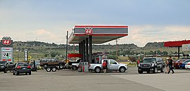
Walsenburg is the statutory city that is the county seat and the most populous municipality of Huerfano County, Colorado, United States. The city population was 3,049 at the 2020 census, down from 3,068 in 2010.

The Town of Kersey is a Statutory Town in Weld County, Colorado, United States. The population was 1,495 at the 2020 United States Census.
Harrisburg is a community now located within the city of Houston, Texas.

Littleton is a home rule municipality city located in Arapahoe, Douglas, and Jefferson counties, Colorado, United States. Littleton is the county seat of Arapahoe County and is a part of the Denver–Aurora–Lakewood, CO Metropolitan Statistical Area. The city population was 45,652 at the 2020 United States Census, ranking as the 20th most populous municipality in the State of Colorado.

Eastlake is an unincorporated community and a U.S. Post Office in Adams County, Colorado, United States. The Eastlake Post Office has the ZIP Code 80614. Most of the Eastlake area has been annexed by the City of Thornton.

Gardner is a census-designated place (CDP) and post office in and governed by Huerfano County, Colorado, United States. The Gardner post office has the ZIP Code 81040. At the United States Census 2020, the population of the Gardner CDP was 106.

Henderson, formerly known as Henderson Island, is an unincorporated community and a U.S. Post Office in Adams County, Colorado, United States. Henderson has the ZIP Code 80640. Portions of the Henderson area have been annexed by Commerce City, Brighton, and Thornton.

Sangre de Cristo Ranches is an unincorporated community located near Fort Garland in Costilla County, Colorado, United States. The U.S. Post Office at Fort Garland serves Sangre de Cristo Ranches postal addresses.

Greenland is an unincorporated community in Douglas County, Colorado, United States. Greenland is located off Exit 167 on Interstate 25. The largest nearby incorporated towns are Larkspur and Monument: Larkspur lies about 7 miles northeast and Monument about 13 miles south of the community. The U.S. Post Office at Larkspur now serves the Greenland postal addresses.

Cuchara is an unincorporated community in Huerfano County, Colorado, United States. It is located near a former ski resort in the mountains south of the town of La Veta. Its altitude is 8,468 feet (2,581 m). State Highway 12 travels through Cuchara as it approaches Trinidad to the southeast.

Lathrop State Park is a Colorado state park located 3 miles (4.8 km) west of Walsenburg. The state purchased the property in 1962 and opened Colorado's first state park here later that same year. It is named after Harold Lathrop, the first director of state parks. The park features two lakes, Martin Lake and Horseshoe Lake, that offer fishing for tiger muskie, rainbow trout, bass, catfish, northern pike, blue gill, saugeye, and wipers.

Cucharas River is a 75-mile-long (121 km) tributary of the Huerfano River that flows from a source in Huerfano County, Colorado, southwest of the Spanish Peaks in San Isabel National Forest. The river passes through La Veta and Walsenburg before joining the Huerfano River in Pueblo County.
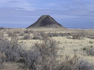
Huerfano Butte is a volcanic plug or hypabyssal plug located 8.8 miles (14.1 km) north of Walsenburg in Huerfano County, Colorado, United States. Named Huérfano by early Spanish explorers, it rises above the south side of the Huerfano River with its peak about 200 feet (61 m) above the floodplain.

Farisita is an unincorporated community in Huerfano County, Colorado, United States.