
Fort Dearborn was a United States fort built in 1803 beside the Chicago River, in what is now Chicago, Illinois. It was constructed by troops under Captain John Whistler and named in honor of Henry Dearborn, then United States Secretary of War. The original fort was destroyed following the Battle of Fort Dearborn during the War of 1812, and a second fort was constructed on the same site in 1816. By 1837, the fort had been de-commissioned.

The Illinois and Michigan Canal connected the Great Lakes to the Mississippi River and the Gulf of Mexico. In Illinois, it ran 96 miles (154 km) from the Chicago River in Bridgeport, Chicago to the Illinois River at LaSalle-Peru. The canal crossed the Chicago Portage, and helped establish Chicago as the transportation hub of the United States, before the railroad era. It was opened in 1848. Its function was partially replaced by the wider and deeper Chicago Sanitary and Ship Canal in 1900, and it ceased transportation operations with the completion of the Illinois Waterway in 1933.

St. Ignace is a city in the U.S. state of Michigan and the county seat of Mackinac County. The city had a population of 2,452 at the 2010 census. St. Ignace Township is located just to the north of the city, but the two are administered autonomously.

Louis Jolliet was a French-Canadian explorer known for his discoveries in North America. In 1673, Jolliet and Jacques Marquette, a Jesuit Catholic priest and missionary, were the first non-Natives to explore and map the Upper Mississippi River.

René-Robert Cavelier, Sieur de La Salle, was a 17th-century French explorer and fur trader in North America. He explored the Great Lakes region of the United States and Canada, the Mississippi River, and the Gulf of Mexico. He is best known for an early 1682 expedition in which he canoed the lower Mississippi River from the mouth of the Illinois River to the Gulf of Mexico; there, on 9 April 1682, he claimed the Mississippi River basin for France after giving it the name La Louisiane. One source states that "he acquired for France the most fertile half of the North American continent".

Jacques Marquette, S.J., sometimes known as Père Marquette or James Marquette, was a French Jesuit missionary who founded Michigan's first European settlement, Sault Sainte Marie, and later founded Saint Ignace. In 1673, Marquette, with Louis Jolliet, an explorer born near Quebec City, was the first European to explore and map the northern portion of the Mississippi River Valley.
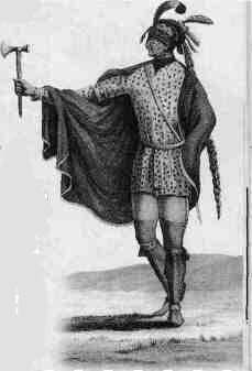
The Kaskaskia were one of the indigenous peoples of the Northeastern Woodlands. They were one of about a dozen cognate tribes that made up the Illiniwek Confederation, also called the Illinois Confederation. Their longstanding homeland was in the Great Lakes region. Their first contact with Europeans reportedly occurred near present-day Green Bay, Wisconsin, in 1667 at a Jesuit mission station.

Events from the 1670s in Canada.

The Illinois Country —sometimes referred to as Upper Louisiana —was a vast region of New France claimed in the 1600s in what is now the Midwestern United States. While these names generally referred to the entire Upper Mississippi River watershed, French colonial settlement was concentrated along the Mississippi and Illinois Rivers in what is now the U.S. states of Illinois and Missouri, with outposts in Indiana. Explored in 1673 from Green Bay to the Arkansas River by the Canadien expedition of Louis Jolliet and Jacques Marquette, the area was claimed by France. It was settled primarily from the Pays d'en Haut in the context of the fur trade, and in the establishment of missions by French Catholic religious orders. Over time, the fur trade took some French to the far reaches of the Rocky Mountains, especially along the branches of the broad Missouri River valley. The French name, Pays des Ilinois, means "Land of the Illinois [plural]" and is a reference to the Illinois Confederation, a group of related Algonquian native peoples.

Fort Michilimackinac was an 18th-century French, and later British, fort and trading post at the Straits of Mackinac; it was built on the northern tip of the lower peninsula of the present-day state of Michigan in the United States. Built around 1715, and abandoned in 1783, it was located along the Straits, which connect Lake Huron and Lake Michigan of the Great Lakes of North America.

Northern Michigan, also known as Northern Lower Michigan, is a region of the U.S. state of Michigan. A popular tourist destination, it is home to several small- to medium-sized cities, extensive state and national forests, lakes and rivers, and a large portion of Great Lakes shoreline. The region has a significant seasonal population much like other regions that depend on tourism as their main industry. Northern Lower Michigan is distinct from the more northerly Upper Peninsula and Isle Royale, which are also located in "northern" Michigan. In the northernmost 21 counties in the Lower Peninsula of Michigan, the total population of the region is 506,658 people.

The Piasa or Piasa Bird is a creature from Native American mythology depicted in one of two murals painted by Native Americans on cliffsides above the Mississippi River. Its original location was at the end of a chain of limestone bluffs in Madison County, Illinois at present-day Alton, Illinois. The original Piasa illustration no longer exists; a newer 20th-century version, based partly on 19th-century sketches and lithographs, has been placed on a bluff in Alton, Illinois, several hundred yards upstream from its origin. The limestone rock quality is unsuited for holding an image, and the painting must be regularly restored. The original site of the painting was on lithographic limestone, which was quarried away in the late 1870s by the Mississippi Lime Company.

Fort Michilimackinac State Park is a state park in the U.S. state of Michigan. It is located in Mackinaw City along the Straits of Mackinac. The park contains Fort Michilimackinac, which itself is dedicated a National Historic Landmark and Old Mackinac Point Lighthouse as well as the Old Mackinac Point Lighthouse Signal Tower which contains a foghorn.
The Chicago Portage was an ancient portage that connected the Great Lakes waterway system with the Mississippi River system. Connecting these two great water trails meant comparatively easy access from the mouth of the St Lawrence River on the Atlantic Ocean to the Rocky Mountains, and the Gulf of Mexico. The approximately six-mile link had been used by Native Americans for thousands of years during the Pre-Columbian era for travel and trade.
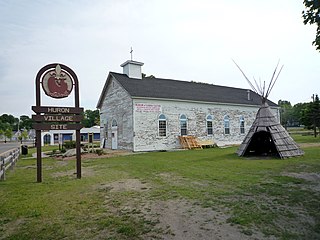
Fort de Buade was a French fort in the present U.S. state of Michigan's Upper Peninsula across the Straits of Mackinac from the northern tip of lower Michigan's "mitten". It was garrisoned between 1683 and 1701. The city of St. Ignace developed at the site, which also had the historic St. Ignace Mission founded by Jesuits. The fort was named after New France's governor at the time, Louis de Buade de Frontenac.
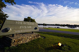
Pere Marquette State Park is an 8,050-acre (3,260 ha) protected area in southwestern Jersey County, Illinois, United States. It is located near the city of Grafton, Illinois, at the confluence of the Mississippi River and the Illinois River. The park is located on Illinois Route 100, which at this location is also part of both the Great River Road and the Meeting of the Great Rivers Scenic Byway. The park is operated and maintained by the Illinois Department of Natural Resources, and is Illinois' largest state park in area. The park is also part of the Confluence Greenway and is at the northwestern end of the 21.5-mile (34.6 km) Sam Vadalabene Bike Trail.

The Chicago Portage National Historic Site is a National Historic Site commemorating the importance of the Chicago Portage in Lyons, Cook County, Illinois, United States. It is located in Chicago Portage Forest Preserve and the Ottawa Trail Woods Forest Preserve, at the junction of Portage Creek with the Des Plaines River, on the west side of Harlem Avenue on the line of 48th Street. Preserved within the park is the western end of the historic portage linking the Chicago River to the Des Plaines River, thereby linking the Great Lakes to the Mississippi River. A memorial depicting the portage of French explorers is located at the parking area. A trail leads from the memorial down into the portage wilderness area.

The St. Ignace Mission is located in a municipal park known as Marquette Mission Park. It was the site of a mission established by Jesuit priest, Father Jacques Marquette, and the site of his grave in 1677. A second mission was established at a different site in 1837, and the chapel was moved here in 1954. The second mission chapel is the oldest Catholic church in Michigan and Wisconsin. The St. Ignace Mission was designated a Michigan State Historic Site in 1956, and was declared a U.S. National Historic Landmarks in 1960, one of the earliest sites recognized. The mission chapel serves as the Museum of Ojibwa Culture.

Marquette Park, originally called Lake Front Park, is a municipal park completely surrounded by Indiana Dunes National Park. Its primary features include 1.4 miles (2.2 km) of Lake Michigan beaches, inland ponds, sand dunes, wetlands, a lagoon, and indigenous oak savanna. The park is located within the Miller Beach community. The park includes the Octave Chanute museum, registered as a National Landmark of Soaring.


