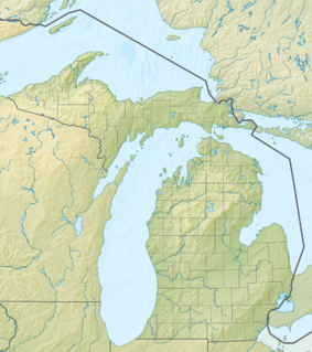
The Upper Peninsulaof Michigan—also known as Upper Michigan or colloquially the U.P.—is the northern and more elevated of the two major landmasses that make up the U.S. state of Michigan; it is separated from the Lower Peninsula by the Straits of Mackinac. It is bounded primarily by Lake Superior to the north, separated from the Canadian province of Ontario at the east end by the St. Marys River, and flanked by Lake Huron and Lake Michigan along much of its south. Although the peninsula extends as a geographic feature into the state of Wisconsin, the state boundary follows the Montreal and Menominee rivers and a line connecting them.

Hiawatha National Forest is a 894,836-acre (362,127 ha) National Forest in the Upper Peninsula of the state of Michigan in the United States. Commercial logging is conducted in some areas. The United States Forest Service administers this National Forest; it is physically divided into two subunits, commonly called the Eastside 46°14′N84°50′W and Westside 46°08′N86°40′W.
Thunder Bay National Marine Sanctuary and Underwater Preserve is a United States National Marine Sanctuary on Lake Huron's Thunder Bay, within the northeastern region of the U.S. state of Michigan. It protects an estimated 116 historically significant shipwrecks ranging from nineteenth-century wooden side-wheelers to twentieth-century steel-hulled steamers. There are a great many wrecks in the sanctuary, and their preservation and protection is a concern for national policymakers. The landward boundary of the sanctuary extends from the western boundary of Presque Isle County to the southern boundary of Alcona County. The sanctuary extends east from the lakeshore to the international border. Alpena is the largest city in the area.
The protected areas of Michigan come in an array of different types and levels of protection. Michigan has five units of the National Park Service system. There are 14 federal wilderness areas; the majority of these are also tribal-designated wildernesses. It has one of the largest state forest systems as well having four national forests. The state maintains a large state park system and there are also regional parks, and county, township and city parks. Still other parks on land and in the Great Lakes are maintained by other governmental bodies. Private protected areas also exist in the state, mainly lands owned by land conservancies.

The Huron Islands are a group of eight small, rocky islands in Lake Superior, located about three miles (4.8 km) off the mouth of the Huron River in northwestern Marquette County, Michigan, United States. Together they comprise the Huron National Wildlife Refuge, which was established by President Theodore Roosevelt in 1905. The refuge is also known as the Huron Islands Wilderness and is a unit of the Seney National Wildlife Refuge. The underwater area around the islands is part of the Huron Islands unit of the Marquette Underwater Preserve and several shipwrecks can be visited by divers.

Michigan Underwater Preserves or Michigan Bottomland Preserves are protected areas of the Great Lakes on Michigan's coast. The thirteen designated areas, comprising a surface area of over 7,000 square miles (18,000 km2), are considered to be "Underwater museums" and serve to protect concentrations of shipwrecks, unique geologic features and other submerged sites through awareness and public interest. The program is currently receiving no funding from the state and does not offer any extra legal protection for the sites in the preserves. However, it is a felony to remove or disturb underwater artifacts in the Great Lakes. Persons apprehended and convicted of removing or willfully damaging underwater artifacts risk confiscation of their equipment, stiff fines and up to two years imprisonment. The Michigan Underwater Preserve Council advocates on behalf of all of Michigan's Underwater Preserves.
The Sanilac Shores Underwater Preserve was established to promote conservation of the submerged historical resources in Lake Huron near Port Sanilac, Michigan. The Sanilac Shores Underwater Preserve spans a total of 163 square miles (420 km2) of Lake Huron. The Michigan Underwater Preserve Council oversees activities relating to all of Michigan's Underwater Preserves.

Michigan consists of two peninsulas surrounded primarily by four of the Great Lakes and a variety of nearby islands. The Upper Peninsula is bounded on the southwest by Wisconsin, and the Lower Peninsula is bounded on the south by Indiana and Ohio. Both land masses are also separated from the Canadian province of Ontario by waterways of the Great Lakes, and from each other by the Straits of Mackinac. Because its land is largely surrounded by the Great Lakes, which flow into the Saint Lawrence River, Michigan is the only U.S. state whose streams and rivers are almost entirely within the Great Lakes-St. Lawrence watershed.

The Whitefish Point Underwater Preserve was established in 1987 to protect and conserve shipwrecks and historical resources on 376 square miles (970 km2) of Lake Superior bottomlands in Whitefish Bay and around Whitefish Point, Michigan. The formation of the Michigan Underwater Preserves helped stop controversy over artifact removal from shipwrecks of this area. The preserve is now known for deep, well preserved shipwrecks in clear water accessible to scuba divers with technical skill and experience. The preserve is one of the last places in the Great Lakes to observe shipwrecks without zebra mussel encrustation.

The SS Vienna was built in 1873 during the era when steamers were built with sail rigging. She had a 19 year career marked with maritime incidents including sinking when she was just three years old. She sank for her final time in fair weather in Whitefish Bay in Lake Superior after she received a mortal blow when she was inexplicably rammed by the steamer Nipigon. Although there were no deaths when the Vienna sank for the last time, more than 100 years later her wreck claimed the lives of 4 scuba divers, the most of all the wrecks in the Whitefish Point Underwater Preserve that now protects her as part of an underwater museum. Her wreck was stripped of artifacts that resulted in the Michigan Department of Natural Resources seizing her artifacts in a raid on the Great Lakes Shipwreck Museum in 1992. Her artifacts are now on display in this museum as loan from the State of Michigan.

The Sagamore is reported to be the best example of a whaleback barge among Great Lakes shipwrecks. Only 44 whalebacks were ever built, and out of the 26 that sank, only 8 sank in the Great Lakes, most of them being blown up for blocking shipping channels. She sank in 1901 in the shipping lane near the Soo Locks when she was rammed by the steel steamer Northern Queen in one of Whitefish Bay's notorious fogs. Her captain and two crew members went down with her. Artifacts from her wreck were illegally removed in the 1980s. Her artifacts are now the property of the State of Michigan and are on display as a loan to the Great Lakes Shipwreck Museum. The wreck of the Sagamore is protected as part of an underwater museum in the Whitefish Point Underwater Preserve.
The DeTour Passage Underwater Preserve is a preservation area in the U.S. state of Michigan. Located in Lake Huron, it completely surrounds Drummond Island and includes all of DeTour Passage and adjacent sections of Lake Huron and the St. Mary's River.
The Manitou Passage Underwater Preserve is a preservation area in the U.S. state of Michigan. Located in Lake Michigan, it completely surrounds North Manitou Island and South Manitou Island. It includes much of that portion of Lake Michigan that borders the federally protected Sleeping Bear Dunes National Lakeshore.
The Alger Underwater Preserve is a preservation area in the U.S. state of Michigan. Located in Lake Superior, it protects waters that lie offshore the Pictured Rocks National Lakeshore and the Grand Island National Recreation Area.
The Thumb Area Underwater Preserve is a preservation area in Lake Huron in the U.S. state of Michigan. It is 276 square miles (710 km2) in size and is located off Michigan's Thumb north of Detroit.

The Miztec was built as a 3-masted schooner in 1890. She was later converted to a schooner barge and served as a consort for lumber hookers on the Great Lakes. She escaped destruction in a severe 1919 storm that sank her longtime companion, the SS Myron, only to sink on the traditional day of bad luck, Friday the 13th, 1921, with the loss of all hands. She came to rest on Lake Superior's bottom off Whitefish Point near the Myron.
SS Isaac M. Scott was an American Great Lakes freighter that sank during the Great Lakes Storm of 1913 in Lake Huron, 6 to 7 miles northeast of Thunder Bay Island, while she was traveling from Cleveland, Ohio, United States to Milwaukee, Wisconsin, United States with a cargo of coal.

East Moran Bay is a small, historic harbor in the Straits of Mackinac adjacent to the city of St. Ignace in the U.S. state of Michigan. The harbor is used as a commercial port for Star Line Ferry and Shepler's Ferry ferry boats from St. Ignace to Mackinac Island, a tourist center of the Straits of Mackinac. The bay and its harbor are guarded by the Wawatam Lighthouse.

The Sport was a tugboat, built in 1873 and wrecked in 1920 in Lake Huron. The wreck site, designated 20UH105, was listed on the National Register of Historic Places in 1992.