Ferriday, Louisiana | |
|---|---|
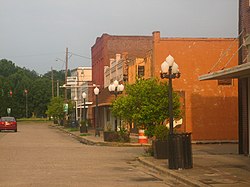 Downtown Ferriday | |
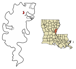 Location of Ferriday in Concordia Parish, Louisiana. | |
 Ferriday Location of Ferriday in Louisiana  Ferriday Location of Ferriday in the United States | |
| Coordinates: 31°37′50″N91°33′24″W / 31.63056°N 91.55667°W | |
| Country | |
| State | |
| Parish | Concordia |
| Government | |
| • Mayor | Sherrie Jacobs |
| Area | |
• Total | 1.63 sq mi (4.22 km2) |
| • Land | 1.63 sq mi (4.22 km2) |
| • Water | 0.00 sq mi (0.00 km2) |
| Elevation | 52 ft (16 m) |
| Population (2020) | |
• Total | 3,189 |
| • Density | 1,957.64/sq mi (755.74/km2) |
| Time zone | UTC-6 (CST) |
| • Summer (DST) | UTC-5 (CDT) |
| ZIP codes | 71334 |
| Area code | 318 |
| FIPS code | 22-25440 |
Ferriday is a town in Concordia Parish, which borders the Mississippi River and is located on the central eastern border of Louisiana, United States. With a population of 3,511 at the 2010 census, [2] it is an African-American majority town.
Contents
- Geography
- Climate
- Demographics
- 2020 census
- 2000 census
- Education
- Notable people
- Photo gallery
- References
- Further reading
- External links
The town claims to have produced more famous people per square mile than any other in America. Elaine Dundy explored both celebrities and townsfolk in her book, Ferriday, Louisiana, published by E. P. Dutton in 1991. [3]
Churches of several major denominations are located here, including a large Pentecostal congregation south of town on Louisiana Highway 15, as well as Baptist, Assembly of God, Presbyterian, Methodist, and Catholic.