Jonesville, Louisiana

Last updated

Jonesville, Louisiana
Troyville
Town
Nickname: 
Bucktown
Catahoula Parish Louisiana Incorporated and Unincorporated areas Jonesville Highlighted.svg
Location of Jonesville in Catahoula Parish, Louisiana.
Louisiana in United States (US48).svg
Location of Louisiana in the United States
Coordinates: 31°37′30″N91°49′35″W / 31.62500°N 91.82639°W / 31.62500; -91.82639
CountryUnited States
StateLouisiana
Parish Catahoula
Government
  MayorMilton Ceasar (D) [1]
Area
[2]
  Total1.92 sq mi (4.97 km2)
  Land1.92 sq mi (4.97 km2)
  Water0.00 sq mi (0.00 km2)
Elevation
59 ft (18 m)
Population
 (2020)
  Total1,728
  Density900.00/sq mi (347.55/km2)
Time zone UTC-6 (CST)
  Summer (DST) UTC-5 (CDT)
ZIP code
71343 [3]
Area code 318
FIPS code 22-38775

Jonesville is the largest town in Catahoula Parish, Louisiana, United States, at the confluence of the Ouachita, Tensas, and Little rivers. The three rivers become the Black River at Jonesville.

Contents

The Jonesville population was 2,265 at the 2010 census. [4]

The four rivers which intersect near Jonesville are all subject to flooding. There are surrounding soybean and cotton fields. A few plantation houses still stand, built during the former slavery-based, planter-dominated economy. The population fell significantly when a textile mill shut down in the late 1980s. [5]

History

Troyville Earthworks Troyville Earthworks HRoe 2017sm.jpg
Troyville Earthworks

Jonesville was once the site of the Troyville Earthworks; built by ancient Native Americans who occupied the site from 100 BCE to 700 CE. Once home to between 9-11 mounds, most have been leveled to make way for the construction of the modern town; including the Great Mound which was once 82 feet (25 m) in height. It was the tallest mound in Louisiana and the second tallest in the United States after Monks Mound at Cahokia in Illinois. It was destroyed for bridge approach fill in 1931. The site is the type site for the Troyville culture of the lower Ouachita and Tensas River valleys. [6] [7]

Geography

Jonesville's northern border is formed by the Little River, while its eastern border is formed by the Black River. The confluence of the Ouachita and Tensas rivers to form the Black River is 0.4 miles (0.64 km) north of the town limits. Concordia Parish is to the east across the Black River.

U.S. Route 84 passes through the town as 4th Street and leads east 16 miles (26 km) to Ferriday and west 23 miles (37 km) to Jena. Louisiana State Highway 124 leads north 10 miles (16 km) to Harrisonburg, the Catahoula Parish seat, and south 24 miles (39 km) to its end in Argo.

According to the United States Census Bureau, Jonesville has a total area of 1.9 square miles (5.0 km2), all land. [4]

Climate

The climate in the area is characterized by hot, humid summers and generally mild-to-cool winters. According to the Köppen Climate Classification system, Jonesville has a humid subtropical climate, abbreviated "Cfa" on climate maps. [8]

Demographics

Historical population
CensusPop.Note
1880 90
1890 17291.1%
1910 287
1920 1,029258.5%
1930 1,1239.1%
1940 2,08085.2%
1950 1,954−6.1%
1960 2,34720.1%
1970 2,76117.6%
1980 2,8282.4%
1990 2,720−3.8%
2000 2,469−9.2%
2010 2,265−8.3%
2020 1,728−23.7%
U.S. Decennial Census [9]

2020 census

Jonesville racial composition [10]
RaceNumberPercentage
White (non-Hispanic)35720.66%
Black or African American (non-Hispanic)1,30375.41%
Native American 40.23%
Asian 20.12%
Pacific Islander 10.06%
Other/Mixed 352.03%
Hispanic or Latino 261.5%

As of the 2020 United States census, there were 1,728 people, 703 households, and 386 families residing in the town.

2000 census

As of the census [11] of 2000, there were 2,469 people, 916 households, and 620 families residing in the town. The population density was 1,291.4 inhabitants per square mile (498.6/km2). There were 1,032 housing units at an average density of 539.8 per square mile (208.4/km2). The racial makeup of the town was 39.77% White, 59.17% African American, 0.28% Native American, 0.12% Asian, and 0.65% from two or more races. Hispanic or Latino of any race were 0.97% of the population.

There were 916 households, out of which 36.0% had children under the age of 18 living with them, 34.7% were married couples living together, 28.2% had a female householder with no husband present, and 32.3% were non-families. 28.7% of all households were made up of individuals, and 11.6% had someone living alone who was 65 years of age or older. The average household size was 2.57 and the average family size was 3.15.

In the town, the population was spread out, with 29.5% under the age of 18, 9.3% from 18 to 24, 26.2% from 25 to 44, 18.7% from 45 to 64, and 16.3% who were 65 years of age or older. The median age was 35 years. For every 100 females, there were 84.7 males. For every 100 females age 18 and over, there were 74.5 males.

The median income for a household in the town was $18,622, and the median income for a family was $23,462. Males had a median income of $21,139 versus $18,482 for females. The per capita income for the town was $10,173. About 31.1% of families and 36.8% of the population were below the poverty line, including 49.7% of those under age 18 and 25.5% of those age 65 or over.


Notable people

See also

Related Research Articles

<span class="mw-page-title-main">Tensas Parish, Louisiana</span> Parish in Louisiana, United States

Tensas Parish is a parish located in the northeastern section of the State of Louisiana; its eastern border is the Mississippi River. As of the 2020 census, the population was 4,147. It is the least populated parish in Louisiana. The parish seat is St. Joseph. The name Tensas is derived from the historic indigenous Taensa people. The parish was founded in 1843 following Indian Removal.

<span class="mw-page-title-main">LaSalle Parish, Louisiana</span> Parish in Louisiana, United States

LaSalle Parish is a parish located in the U.S. state of Louisiana. As of the 2020 United States Census, the population was 14,791. The parish seat is Jena. The parish was created in 1910 from the western section of Catahoula Parish and named for René-Robert Cavelier, Sieur de La Salle.

<span class="mw-page-title-main">Concordia Parish, Louisiana</span> Parish in Louisiana, United States

Concordia Parish borders the Mississippi River in eastern central Louisiana. As of the 2020 census, the population was 18,687. The parish seat is Vidalia. The parish was formed in 1807.

<span class="mw-page-title-main">Catahoula Parish, Louisiana</span> Parish in Louisiana, United States

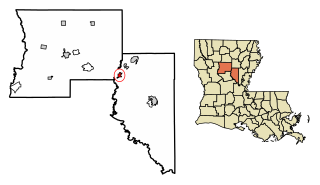
Catahoula Parish is a parish in the U.S. state of Louisiana. As of the 2020 census, the population was 8,906. Its seat is Harrisonburg, on the Ouachita River. The parish was formed in 1808, shortly after the United States acquired this territory in the Louisiana Purchase of 1803.

<span class="mw-page-title-main">Mount Ida, Arkansas</span> City in Arkansas, United States

Mount Ida is a city in and county seat of Montgomery County, Arkansas, United States. Founded in 1842, the city saw a silver boom in the 1880s bring early prosperity and economic development to the area. Today, the economy is largely ranching, poultry farming, silviculture, and tourism around Lake Ouachita. It is known as the quartz crystal capital of the U.S. and is known worldwide for its quartz deposits. The population was 996 as of the 2020 census.

<span class="mw-page-title-main">Jonesville, Indiana</span> Town in Indiana, United States

Jonesville is a town in Wayne Township, Bartholomew County, in the U.S. state of Indiana. The population was 177 at the 2010 census. It is part of the Columbus, Indiana metropolitan statistical area.

<span class="mw-page-title-main">Hosston, Louisiana</span> Village in Louisiana, United States

Hosston is a village in Caddo Parish, Louisiana, United States. The population was 318 at the 2010 census. It is part of the Shreveport–Bossier City Metropolitan Statistical Area.

<span class="mw-page-title-main">Harrisonburg, Louisiana</span> Village in Louisiana, United States

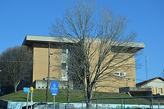
Harrisonburg is a village in and the parish seat of Catahoula Parish, Louisiana, United States. The population was 348 as of the 2010 census, down from 746 in 2000.

<span class="mw-page-title-main">Sicily Island, Louisiana</span> Village in Louisiana, United States

Sicily Island is a village in Catahoula Parish, Louisiana, United States. The population was 336 at the 2020 census.

<span class="mw-page-title-main">Clayton, Louisiana</span> Town in Louisiana, United States

Clayton is a town in northern Concordia Parish, Louisiana, United States. The population was 711 at the 2010 census. Cotton is a principal commodity in the area. Clayton is located on the Tensas River, important for fishing and boating, promoted through a U.S. Army Corps of Engineers-maintained boat launch. The Tensas River merges with the Black River in Jonesville in Catahoula Parish.

<span class="mw-page-title-main">Ferriday, Louisiana</span> Sole incorporated city in Louisiana, United States

Ferriday is a town in Concordia Parish, which borders the Mississippi River and is located on the central eastern border of Louisiana, United States. With a population of 3,511 at the 2010 census, it is an African-American majority town.

<span class="mw-page-title-main">Jena, Louisiana</span> Town in Louisiana, United States

Jena is a town in, and the parish seat of, La Salle Parish, Louisiana, United States. The population was 4,155 at the 2020 census.

<span class="mw-page-title-main">Mound, Louisiana</span> Village in Louisiana, United States

Mound is a village in Madison Parish, Louisiana, United States. With a population of 12 at the 2020 census, it is Louisiana's smallest village by population. Its ZIP Code is 71282. It is part of the Tallulah Micropolitan Statistical Area.

<span class="mw-page-title-main">Bonita, Louisiana</span> Village in Louisiana, United States

Bonita is a village in Morehouse Parish, Louisiana, United States. The population was 170 at the 2020 census, down from 284 in 2010.

<span class="mw-page-title-main">Waterproof, Louisiana</span> Village in Louisiana, United States

Waterproof is a village in Tensas Parish in northeastern Louisiana, United States with a population of 688 as of the 2010 census. The village in 2010 was 91.7 percent African American. Some 24 percent of Waterproof residents in 2010 were aged sixty or above.

<span class="mw-page-title-main">Jonesville, Virginia</span> Town in southwest Virginia, US

Jonesville is a town in and the county seat of Lee County, Virginia, United States. The population was 1,034 at the 2010 census.

<span class="mw-page-title-main">Tullos, Louisiana</span> Town in Louisiana, United States

Tullos is a town in LaSalle and Winn parishes in the U.S. state of Louisiana, along Castor Creek. The population was 385 at the 2010 census.

<span class="mw-page-title-main">Ouachita River</span> River in Arkansas and Louisiana, United States

The Ouachita River is a 605-mile-long (974 km) river that runs south and east through the U.S. states of Arkansas and Louisiana, joining the Tensas River to form the Black River near Jonesville, Louisiana. It is the 25th-longest river in the United States.

<span class="mw-page-title-main">Troyville Earthworks</span> Woodland period Native American archaeological site in Jonesville, Louisiana, United States

Troyville Earthworks is a Woodland period Native American archaeological site with components dating from 100 BCE to 700 CE during the Baytown to the Troyville-Coles Creek periods. It once had the tallest mound in Louisiana at 82 feet (25 m) in height. It is located in Catahoula Parish, Louisiana in the town of Jonesville. The site is the type site for the Troyville culture of the lower Ouachita and Tensas River valleys. Before it was destroyed for bridge approach fill in 1931, the main mound at Troyville was one of the tallest in North America.

Wallace Ridge is an unincorporated community and census-designated place (CDP) in Catahoula Parish, Louisiana, United States. As of the 2010 census it had a population of 710. It is located northeast of the center of Catahoula Parish on the west side of the Ouachita River. Tew Lake, a former channel of the river that is now an oxbow lake, is in the northern part of the CDP, and Wallace Lake, another oxbow, borders the southern part. The original community of Wallace Ridge is on relatively higher ground on the north side of Tew Lake.

References

  1. "Election Returns: Catahoula Parish". Louisiana Secretary of State. November 6, 2018. Archived from the original on May 18, 2019. Retrieved November 9, 2018.
  2. "2020 U.S. Gazetteer Files". United States Census Bureau. Retrieved March 20, 2022.
  3. "Jonesville LA ZIP Code". zipdatamaps.com. 2023. Retrieved June 16, 2023.
  4. 1 2 "Geographic Identifiers: 2010 Demographic Profile Data (G001): Jonesville town, Louisiana". U.S. Census Bureau, American Factfinder. Archived from the original on February 12, 2020. Retrieved August 18, 2014.
  5. Michael E. Miller (September 17, 2016). "A white police chief rants on Facebook, and a Louisiana town hears echoes of its racist past". The Washington Post . Archived from the original on February 22, 2017. Retrieved February 20, 2017.
  6. "Indian Mounds of Northeast Louisiana: Troyville Earthworks". Louisiana Dept. Of Culture, Recreation & Tourism. Archived from the original on May 3, 2017. Retrieved December 22, 2017.
  7. "Final excavation of Troyville Mounds underway". Catahoula Parish History. April 18, 2005. Archived from the original on April 25, 2012. Retrieved October 22, 2011.
  8. "Climate Summary for Jonesville, Louisiana". Archived from the original on October 3, 2015. Retrieved November 18, 2013.
  9. "Census of Population and Housing". Census.gov. Retrieved June 4, 2015.
  10. "Explore Census Data". data.census.gov. Retrieved December 29, 2021.
  11. "U.S. Census website". United States Census Bureau. Retrieved January 31, 2008.