
Pushmataha County is a county in the southeastern part of the U.S. state of Oklahoma. As of the 2010 census, the population was 11,572. Its county seat is Antlers.

Tuskahoma is an unincorporated community and census-designated place in northern Pushmataha County, Oklahoma, United States, four miles east of Clayton. It was the former seat of the Choctaw Nation government prior to Oklahoma statehood. The population at the 2010 census was 151.
Fewell is a community in eastern Pushmataha County, Oklahoma, United States. Fewell is located at 34°31′05″N95°03′14″W.
Honobia is an unincorporated community on the border between western LeFlore County and eastern Pushmataha County, Oklahoma, United States, 15 miles southeast of Talihina.

Snow School is a historic school building in the rural community of Snow, Oklahoma, approximately 18 miles north of Antlers, Oklahoma. The school was added to the National Register of Historic Places in 1988.
The Pushmataha County Historical Society is a historical society devoted to collecting and preserving the history of Pushmataha County, Oklahoma. It is headquartered in the historic Frisco Depot in Antlers, Oklahoma, which it operates as a public museum.
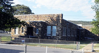
Clayton High School Auditorium is an historic structure serving the public school of Clayton, Oklahoma. Clayton is located in the Kiamichi Mountains of Pushmataha County, Oklahoma.
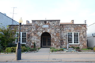
The American Legion Hall is a historic social meeting hall at Race and Spruce Streets in the center of Searcy, Arkansas. It is a single-story structure, built out of native fieldstone in 1939 with funding support from the Works Progress Administration (WPA). Its main block has a side-facing gable roof, with a projecting flat-roof section in which the entrance is recessed under a rounded archway. The building is typical of rustic-styled buildings constructed by the WPA and other jobs programs of the Great Depression.

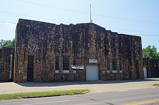
The Coalgate School Gymnasium-Auditorium is a historic school building in Coalgate, Oklahoma. It is located at the intersection of Fox and Frey streets in Coalgate, Oklahoma and is one of several properties in Southeastern Oklahoma constructed by the Works Progress Administration during the Great Depression. It is listed on the National Register of Historic Places.
The Keel Creek Bridge is a bridge on Oklahoma State Highway 31 seven miles northeast of Coalgate, Oklahoma. The bridge is listed on the National Register of Historic Places. It was constructed as a Works Progress Administration project. The bridge is significant because of its importance to the transportation history of the area and because it is a WPA-built structure.
The Merchants National Bank Building is a two-story, red brick building in Lehigh, Oklahoma, located at the southwest corner of Main Street and Railway Street. It was one of two banks that served Lehigh during the town's mining boom. It is listed on the National Register of Historic Places. It is historically significant because it represents the economic growth and decline of Lehigh and exemplifies Late Victorian Renaissance architecture.
The Dog Creek School, near Shady Point, Oklahoma, is a one-room school built in 1936 as a Works Progress Administration project. It was listed on the National Register of Historic Places in 1988.

The Tucker School was a three-room schoolhouse built in 1937 as a Works Progress Administration project in a rural area outside of Spiro in LeFlore County, Oklahoma. It was listed on the National Register of Historic Places in 1988.
The Shady Point School, located on the northeastern edge of the community of Shady Point in Le Flore County, Oklahoma, was built in 1936 as a Works Progress Administration project. It was listed on the National Register of Historic Places in 1988.

The Poteau School Gymnasium-Auditorium, located at Walter and Parker Sts. in Poteau in Le Flore County, Oklahoma, was built in 1937. It was listed on the National Register of Historic Places in 1988.
The Idabel Armory in Idabel, Oklahoma was built in 1936 as a Works Progress Administration (WPA) project. It was listed on the National Register of Historic Places in 1988.
The Dustin Agricultural Building in Dustin, Oklahoma was built as a Works Progress Administration project in 1936. It is located at Rutherford and Fourth Streets. It was listed on the National Register of Historic Places in 1988.

The Robert E. Lee School, at Ninth and Louisiana Streets in Durant, Oklahoma, was built in 1937. It was listed on the National Register of Historic Places in 1988.

The 7-D School, in Las Animas County, Colorado, near Branson, Colorado, was built during 1936-37 as a Works Progress Administration project. It was listed on the National Register of Historic Places in 2009.
The Hugo Public Library built in 1936–37, on E. Jefferson St. in Hugo, Oklahoma, was listed on the National Register of Historic Places in 1988. It was a Works Progress Administration project.

