Filipstad, Norway

Last updated
The container port Filipstad kontainerhavn.jpg
The container port
The neighborhood, about 1900. Filipstad map 1900.jpg
The neighborhood, about 1900.

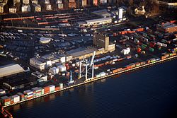
Filipstad is a neighborhood in the Frogner borough in Oslo, Norway. It serves both as a major container port and ferry terminal for the city. The Oslo-Kiel ferry docks by the Hjortneskaia at Filipstad.

Contents

History

The neighborhood grew from a single property Philipsborg, named after the pharmacist Philip Moth, around 1650. From 1805 the property belonged to the Heftye family. The villa at the site dates from 1864 and was initiated by banker Jørgen H. Heftye who commissioned the famous architect G. A. Bull for its design. [1] The property is now represented with the mentioned building Villa Filipstad at the address Munkedamsveien 62.

The former Filipstad inlet (between Tjuvholmen and Munkedamsveien) used to serve as a place for bathing, but the water was contaminated by the Filipstad stream. From around 1870 the inlet was gradually filled in to serve as a future port.

When the Norwegian State Railways bought the area in 1909, the villa was made the residence of the company's director. After the takeover by the State the area was seriously converted into a port. In 1943 the Filipstad Accident took place here. The Drammen Line went through the area until 1980, after which it is served by the Skøyen–Filipstad Line.

The neighboring area Aker Brygge, a former ship yard, went through an urban renewal in the 1980s.

The Fjord City

MS Color Fantasy of Color Line in port at Fillipstad Filipstad (29. april 2018).jpg
MS Color Fantasy of Color Line in port at Fillipstad

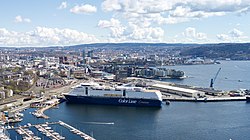
Due to the central location of Filipstad it has been suggested, in the urban renewal project The Fjord City, to convert the container port into a new urban area similar to Akerbrygge and Tjuvholmen. The Color Line cruiseferry terminal is presumed to be kept.

The almost 40 meter tall landmark building of Filipstad, the Ali Coffee roasting factory, owned by the Joh. Johannson company, is scheduled to close down in the year 2020 when the business will be relocate to new facilities outside Oslo. [2]

The two largest landowners of Filipstad are Oslo Port Authority and Bane NOR owned Bane NOR Eiendom. [3] In addition the Norwegian Public Roads Administration is the owner of the E18 motorway. It is disputed what to do about the traffic situation of E18 and how the outcome of this issue will influence on the Fjord City development of Filipstad. [4]

The name

The area is named after the pharmacist Philip Moth who owned the property around 1650 and used it as a herb garden. The last element is stad 'property; farm'.

Related Research Articles

<span class="mw-page-title-main">Oslofjord</span> Inlet in South-East Norway

The Oslofjord is an inlet in the south-east of Norway, stretching from an imaginary line between the Torbjørnskjær and Færder lighthouses and down to Langesund in the south to Oslo in the north. It is part of the Skagerrak strait, connecting the North Sea and the Kattegat sea area, which leads to the Baltic Sea. The Oslofjord is not a fjord in the geological sense — in Norwegian the term fjord can refer to a wide range of waterways.

<span class="mw-page-title-main">Oslo Central Station</span> Railway station in Oslo, Norway

Oslo Central Station is the main railway station in Oslo, and the largest railway station within the entire Norwegian railway system. It connects with Jernbanetorget station. It's the terminus of Drammen Line, Gardermoen Line, Gjøvik Line, Hoved Line, Østfold Line and Follo Line. It serves express, regional and local rail services by four companies. The railway station is operated by Bane NOR while its real estate subsidiary, Bane NOR Eiendom owns the station, and was opened in 1980.

<span class="mw-page-title-main">Douglas Channel</span> Body of water

Douglas Channel is one of the principal inlets of the British Columbia Coast. Its official length from the head of Kitimat Arm, where the aluminum smelter town of Kitimat to Wright Sound, on the Inside Passage ferry route, is 90 km (56 mi). The actual length of the fjord's waterway includes waters between there and the open waters of the Hecate Strait outside the coastal archipelago, comprising another 60 km (37 mi) for 140 km (87 mi)in total.

<span class="mw-page-title-main">Skollenborg</span> Small village in Buskerud country, Norway

Skollenborg is a small village in Sandsvær in the municipality of Kongsberg in Viken county, Norway. Since 2015 Skollenborg has been a part of the Kongsberg urban area.

<span class="mw-page-title-main">Bjørvika</span>

Bjørvika is a neighborhood in the Sentrum borough of Oslo, Norway. The area is an inlet in the inner Oslofjord, situated between Gamlebyen and Akershus Fortress. It serves as an outlet for the river Akerselva. Since the 2000s, it has been undergoing urban redevelopment, being transformed from a container port. When completed, the Bjørvika neighborhood will be a new cultural and urban center in Oslo. The multi-purpose medium-rises of the Barcode Project dominates the skyline to the north; to the east the residential area of Sørenga is under construction. The National Opera is located at Bjørvika, and both the Oslo Public Library and the Munch/Stenersen museum is currently under construction here, the latter replacing the existing Munch Museum in 2020.

<span class="mw-page-title-main">Trondheim Central Station</span> Railway station in Trondheim, Norway

Trondheim Central Station or Trondheim S is the main railway station serving the city of Trondheim, Norway. Located at Brattøra in the north part of the city centre, it is the terminus of the Dovre Line, running southwards, and the Nordland Line, which runs north. The railway is electrified south of the station but not north of it, so through trains must change locomotives at the station.

<span class="mw-page-title-main">Aker Brygge</span> Place in Oslo, Norway

Aker Brygge is a neighbourhood in central Oslo, Norway. Since the 1980s and 1990s it has been a popular area for shopping, dining, and entertainment, as well as a high-end residential area. It was previously an industrial area.

Bane NOR Eiendom is a subsidiary of Bane NOR responsible for managing the commercial sections of the company's real estate. With headquarters in Oslo, the company manages 740,000 square metres (8,000,000 sq ft) of space. The vast majority of this is in or in connection with railway stations. The company owns all of the railway stations in Norway.

<span class="mw-page-title-main">Vippetangen</span>

Vippetangen is the southern tip of the Akersnes peninsula in central Oslo, Norway, located southeast of Akershus Fortress and bounded on three sides by the Oslofjord. It has in the past served as an important part of the port of Oslo. The area is currently undergoing urban renewal as part of the Fjord City development.

The Vippetangen Line or the Grain Tram is an abandoned line of the Oslo Tramway, Norway, that ran from Tollbugata in the city center to Vippetangen between 1900 and 1967. It was built by Kristiania Kommunale Sporveie (KKS).

<span class="mw-page-title-main">Vika Line</span> Railway line in Vika, Oslo

The Vika Line is a light rail section of the Oslo Tramway in Oslo, Norway. It runs between Wessels plass, through the neighborhood of Vika and Aker Brygge, before arriving at Solli. The section is served by SL79 trams on line 12. The line is owned by the municipal company Kollektivtransportproduksjon, and operated by its subsidiary Oslo Sporvognsdrift.

<span class="mw-page-title-main">Tjuvholmen</span> Neighborhood in Oslo

Tjuvholmen is a neighborhood in the borough Majorstuen in Oslo, Norway. It is located on a peninsula sticking out from Aker Brygge into the Oslofjord. It is located east of Filipstad and south of Vika. At the tip of the peninsula, next to the sculpture park, is an outdoor bathing area. The water leads out to the Inner Oslofjord.

<span class="mw-page-title-main">Sørengautstikkeren</span>

Sørengautstikkeren is a neighborhood in the borough Gamle Oslo in Oslo, Norway. It is an artificial peninsula that sticks out into the Oslofjord form Bjørvika and Sørenga. It is part of the Port of Oslo, but will be redeveloped as part of the Fjord City urban redevelopment program, after the Bjørvika Tunnel is completed in 2010, and the European Route E18 will run under the area. Until then, it is used as a container port, a quay for cruise ships and as a storage area for earth and bulk. The quay is 880 metres (2,890 ft) long.

<span class="mw-page-title-main">Fjord City</span>

The Fjord City is an urban renewal project for the waterfront part of the centre of Oslo, Norway. The first redevelopment was at Aker Brygge during the 1980s. Bjørvika and Tjuvholmen followed up during the 2000s, while the remaining parts of the Port of Oslo will be developed in the 2010s. The port will be relocated to Sørhavna. The planning is performed by the Oslo Waterfront Planning Office. Major investments in the area include a new Central Railway Station, an already completed Oslo Opera House, and the commercial buildings in the Barcode Project. Several large cultural institutions will be moved to Bjørvika, including moving the Oseberg Ship, Oslo Public Library, and the Munch Museum. The main barrier between the city and the fjord will disappear when European Route E18 is relocated to the Bjørvika Tunnel.

HAV Eiendom AS is a stock-based company that is responsible for the urban redevelopment of the Bjørvika area of Oslo, Norway. Owned by the Oslo Port Authority, the former owner of the Bjørvika area, the company's goal is to "participate in the urban development of the Bjørvika area through development, rental, management, purchase and sale of real estate in the Bjørvika area". HAV Eiendom also has ownership interests in companies that run similar businesses and own 66 percent of Bjørvika Utvikling AS, which owns 100 percent of Bjørvika Infrastruktur AS. The company is also a minority owner of housing development in Bjørvika. The company was founded on 7 April 2003, in order to create a sustainable fjord city in Bjørvika and to make value for Oslo, the harbour, and society.

<span class="mw-page-title-main">Thomas Johannessen Heftye</span> Norwegian politician

Thomas Johannessen Heftye, also known as Tho Joh Heftye was a Norwegian businessman, politician and philanthropist.

<span class="mw-page-title-main">Villa Filipstad</span> 19th-century Norwegian building

Villa Filipstad is a notable building in the neighborhood Filipstad in Oslo, Norway. It is located at Munkedamsveien 62. The villa is very prominent in the terrain, being situated atop a crag. It is similar to, and can be viewed from, Oscarshall across Frognerkilen.

<span class="mw-page-title-main">Barcode Project</span> Office building precinct in Oslo, Norway

The Barcode Project is a section of the Bjørvika portion of the Fjord City redevelopment on former dock and industrial land in central Oslo. It consists of a row of new multi-purpose high-rise buildings, that was completed in 2016. The developer is marketing the project as "The Opera Quarter." There has been intense public debate about the height and shape of the buildings.

<span class="mw-page-title-main">1943 Filipstad explosion</span>

The 1943 Filipstad explosion was a fire in an ammunition store at Filipstad in Oslo on Sunday, 19 December 1943, during the occupation of Norway by Nazi Germany. The fire started during the unloading of ammunition from the transport ship Selma. The estimated amount of exploded ammunition varies from 800 to 1,200 tons. A large number of shells and grenades were tossed into the air and spread over the city. There were around 40 Norwegian casualties and around 75 Germans were killed, and 400 wounded. About 400 buildings were severely damaged.

A fjord a long, narrow inlet with steep sides or cliffs, created by a glacier.

References

  1. "Bane NOR Eiendom - Generaldirektørboligen på Filipstad - Generaldirektørboligen på Filipstad".
  2. "Satser 250 mill. I nytt kaffehus". 15 October 2014.
  3. "Filipstad - Oslo Havn". www.oslohavn.no. Archived from the original on 2011-11-10.
  4. "Oslo - Aftenposten".

Coordinates: 59°54′30″N10°42′53″E / 59.9083°N 10.7148°E / 59.9083; 10.7148