Finglas (civil parish)

Last updated

Finglas (Irish : Fionnghlas) [1] is a civil parish mainly situated in the barony of Castleknock in the traditional county of Dublin, Ireland. It contains 34 townlands. Today, the parish is split between two local government areas: the modern county of Fingal (to the west) and Dublin City Council (to the east).

Contents

Location

Like all civil parishes in Ireland, this civil parish is derived from, and co-extensive with, a pre-existing parish of the Church of Ireland. The Archdiocese of Dublin held a number of manors as cross lands. The manor of Finglas contained most of the area of the parish in four distinct parcels of 4,487 acres in total. [2] The core of the parish is centered on the village of Finglas, which lies within the barony of Castleknock. However, a substantial exclave of the parish is situated within the neighbouring barony of Nethercross. Since Kilreesk has a cell toponym, this suggests that the church was a pre-Invasion chapel of ease. [3] This parcel of land contains six townlands. Additionally, within the barony of Castleknock itself, two further parcels of land, that are distinct from the core around the village, are situated to the north of the barony. The larger parcel contains six townlands around the Kilshane chapel of ease. [3] The smaller parcel consists of a single townland and is surrounded by the civil parishes of Mulhuddart and Cloghran.

Townlands

Townlands in the civil parish of Finglas [4]
Contiguous portion Local authority Townland nameIrish nameComments
Core village in barony of Castleknock Fingal BalseskinBaile SeiscinnCentral part contains the ramps and ancillary roads of the interchange where the M50 crosses the old North Road (N3) at junction 6.
CharlestownBaile ShéarlaisIts southern edge forms the Fingal / City boundary
ColdwintersBuaile an GheimhridhThe most northerly point of this part of the parish.
Jamestown Little (partly)Baile Shéamais BeagLocated on the western side of the Jamestown Road.The top half of the townland and of the Jamestown Industrial Estate is in Fingal.
Kildonan (partly)Cill DónáinMost of the land lies on the M50 ramp and north of the motorway.Access is only possible from the cul-de-sac on the old N3 at Coldwinters.
StockensStoicínIts northern edge forms the Fingal / City boundary
Dublin City Ballyboggan NorthBaile Bogáin ThuaidhIts southern border is the river Tolka. It is bisected by the Tolka Valley Road.
Ballyboggan SouthBaile Bogáin TheasBounded by the Tolka to the north and the Royal Canal to the south.Bisected by the Broombridge Road (north to south).
Ballygall Baile GallThe Hillcrest Park housing estate was built on the site of Ballygall House.
CabraghAn ChabrachThe most southerly point of this part of the parish.Adjoins two other townlands or the same name in two neighbouring parishes(Castleknock and Grangegorman). Contains Broombridge railway station.
CardiffsbridgeDroichead ChairdifLocated in the south-west corner of the parish. The river Tolka is the southern boundary.The Ratoath Road runs diagonally through it from top to bottom.
CardiffscastleCaisleán ChairdifForms the boundary with Fingal to the west and north at Northern Cross Business Park.Bounded to the east by the R135 and to the south by the Cappagh Road.
Finglas EastFionnghlas ThoirThis townland at the heart of the village has the greatest area in the parish at 327 acres.
Finglas WestFionnghlas ThiarLocated to the west of the N2, this part of the village goes from Ratoath Drive in the westto Farnham Drive in the east and Cappagh Road to the north.
Glasnevin DemesneDiméin Ghlas NaíonEntirely surrounded by Tolka and by a townland of the same name to the eastin the parish of Glasnevin.
GlebeAn GhléibNorthern edge forms the Fingal / City boundary
Finglas WoodCoill FhionnghlaiseFinglaswood House was situated in what in now the Tolka Valley Park.
Jamestown GreatBaile Shéamais MórLocated on the eastern side of the Jamestown Road.
Jamestown Little (partly)Baile Shéamais BeagLocated on the western side of the Jamestown Road.The bottom half of the townland and of the Jamestown Industrial Estate is in the City.
JohnstownBaile SheáinThe central part of the townland is now the site of Johnstown Park.
Kildonan (partly)Cill Dónáin
Poppintree Crann PhapáinAdjacent to the larger townland of the same name in the neighbouring parish of Santry.
SpringmountCnocán an FhuaráinCentred on Cardiffsbridge Road and Wellmount Road.Its southern boundary is the river Tolka.
StangAn StangAt the junction of Glasnevin Avenue and Willow Park Road
TolkaAn TulchaStraddles the Finglas Road from the River Tolka in the south to the village.
Large exclave in barony of Castleknock Fingal BishopswoodCoill an EaspaigSeparated from Broghan by a tributary of the Ward river.
BroghanAn BruachánStraddles the old North Road (N2). Separated from Bishopswood by a tributary of the Ward river.
KilshaneCill SheáinThe townland links Tyrrelstown in the west with St Margaret's in the east.Kilshane House still stands.The motte at the northern end has been obliterated.
ShallonSealúinThe most northerly point of this part of the parish.Its larger neighbour of the same name lies to the east in the parish of Killsallaghan.
Small exclave in barony of Castleknock Fingal CruiserathRáth an ChrúisighA single townland surrounded on three sides by the parish of Mulhuddart and to the south-east by Cloghran.A "daisy chain" of four roundabouts separates it from Tyrrelstown to the west.The largest development is the "Rosemount Business Park".
Exclave in barony of Nethercross Fingal BallystrahanBaile an tSrutháinBisected from north to south by the R122.
KilreeskCill RéiscThe most southerly point of the exclave. Bounded to the east by the R122.Separated from the Castleknock exclave by the townland of Kilmacree in the parish of Killsallaghan.
LaurestownBaile LabhráisBounded to the west by the R122 and to the south by the Ward river.
SkephubbleSceich an PhubaillBounded to the west by the R122 and to the north by the Ward river.
ToberburrTobar BoirBisected from west to east by the Ward river.The townland of Westereave is an enclave of this townland.A second enclave is an enclave of the parish of Killeek.
WestereaveWestereaveThis strip of land is less than an acre in area.It is separated from its eponymous neighbour of 170 acres which lies in the parish of Killeek.It is entirely surrounded by the townland of Toberburr.

Related Research Articles

<span class="mw-page-title-main">Finglas</span> Outer suburb of Dublin, Ireland

Finglas is a northwestern outer suburb of Dublin, Ireland. It lies close to Junction 5 of the M50 motorway, and the N2 road. Nearby suburbs include Glasnevin and Ballymun; Dublin Airport is seven km (4.3 mi) to the north. Finglas lies mainly in the postal district of Dublin 11.

<span class="mw-page-title-main">Fingal</span> County in Ireland

Fingal is a county in Ireland. It is in the province of Leinster and is part of the Eastern and Midland Region. It is one of three successor counties to County Dublin, which was disestablished for administrative purposes in 1994. Its name is derived from the medieval territory of Scandinavian foreigners that settled in the area. Fingal County Council is the local authority for the county. In 2022 the population of the county was 330,506, making it the second most populated council in Dublin and the third most populous county in the state.

<span class="mw-page-title-main">Blanchardstown</span> Large western suburb of Dublin, Ireland

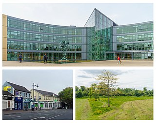
Blanchardstown is a large outer suburb of Dublin in the modern county of Fingal, Ireland. Located ten kilometres (6 mi) northwest of Dublin city centre, it has developed since the 1960s from a small village to a point where Greater Blanchardstown is the largest urban area in Fingal.

Castleknock is an affluent suburb located 8 km (5 mi) west of the centre of Dublin city, Ireland. It is centred on the village of the same name in Fingal.

<span class="mw-page-title-main">Mulhuddart</span> Outer suburb of Dublin, Ireland

Mulhuddart is an outer suburb situated 12 km north-west of Dublin, Ireland. The River Tolka passes near the village.

<span class="mw-page-title-main">Dublin 15</span> Postal district of Dublin, Ireland

Dublin 15, also rendered as D15, is a postal district in the suburbs of Dublin in Fingal, Ireland. It is 11 km (6.8 mi) west of the GPO in Dublin city.

<span class="mw-page-title-main">Chapelizod</span> Northside village suburb of Dublin city, Ireland

Chapelizod is a village preserved within the city of Dublin, Ireland. It lies in the wooded valley of the River Liffey, near the Strawberry Beds and the Phoenix Park. The village is associated with Iseult of Ireland and the location of Iseult's chapel. Chapelizod is under the administration of Dublin City Council.

<span class="mw-page-title-main">Kilcloon</span> Parish in County Meath, Ireland

Kilcloon or Kilclone is a parish situated in the south-east of County Meath in Ireland. Kilcloon parish is largely rural and contains the village of Kilcloon itself and the neighbouring villages of Batterstown and Mulhussey. The parish church is located at Ballynare Cross Roads in the village of Kilcloon with chapels in Kilcock and Batterstown.

Ballygall is a small suburban area located between Glasnevin and Finglas, on the northside of the city of Dublin, Ireland. It is also a townland divided between the civil parish of Finglas and that of Glasnevin. It was settled by Vikings in the 11th century, and later by the Cambro-Normans.

The barony of Castleknock is one of the baronies of Ireland. Originally part of the Lordship of Meath, it was then constituted as part of County Dublin. Today, it is in the modern county of Fingal, Ireland. The barony was originally also a feudal title, which became one of the subsidiary titles of the Viscounts Gormanston.

Waterville is a housing development near Dublin city, within Fingal, Ireland. The development was built between 2002 and 2008 as well as between 2013 and 2016 on the edge of the Abbotstown demense, close to Blanchardstown village. The development lies within the townland of Deanestown in the civil parish of Castleknock.

Abbotstown is a townland in the civil parish of Castleknock in Fingal, Ireland. It is also the name of an historical demesne and country estate that is close to Blanchardstown. Historically the estate belonged to a number of aristocratic families. When these neighbouring families intermarried, their combined estates in Abbotstown and the townland of Sheephill were usually, though informally, called "Abbotstown". Despite a significant level of suburban development in the wider Dublin 15 area from the 1980s onwards, Abbotstown and Sheephill remained largely undeveloped, as the demesne was held by several state bodies. Today, the majority of the combined demesne remains unspoilt and now accommodates the administration offices and sporting grounds of the various bodies associated with Ireland's National Sports Campus. Abbotstown proper, however, does not contain any part of the campus nor the eponymous Abbotstown House itself. Instead, almost the whole of the land is given over to Connolly Hospital and the "St Francis Hospice".

Nethercross is a feudal title of one of the baronies of Ireland. Originally part of the Lordship of Meath, it was then constituted as part of the County Dublin. Today, is in the modern county of Fingal.

<span class="mw-page-title-main">Kilbride, County Wicklow</span> Village in County Wicklow, Ireland

Kilbride, or Manor Kilbride, is a village, civil parish and electoral division in County Wicklow, Ireland, located at the western edge of the Wicklow Mountains in the barony of Talbotstown Lower.

<span class="mw-page-title-main">Ward, Castleknock</span> Civil parish in Fingal, Ireland

Ward is a civil parish in Fingal, Ireland. It is part of the historical barony of Castleknock. The Ward River, the major tributary of the Broadmeadow River, flows through the area, and probably gave the civil parish its name.

<span class="mw-page-title-main">St Thomas the Apostle parish, Laurel Lodge</span> Church in Fingal, Ireland

St Thomas, the Apostle parish is an ecclesiastical parish in the Blanchardstown deanery of the Roman Catholic Archdiocese of Dublin. It is served by the church of "St Thomas, the Apostle". The parish is centered on "Laurel Lodge" district and the townland of Carpenterstown in the civil parish of Castleknock, Fingal in Ireland. On 6 June 2018, the Archbishop of Dublin, Diarmuid Martin, concelebrated mass in the parish church on the occasion of the 25th anniversary of the laying of the building's foundation stone.

Castleknock is a civil parish and a townland located in the south-western corner of the modern county of Fingal, Ireland. The civil parish is part of the ancient barony of Castleknock. It is centred on the suburban village of Castleknock. The townland of Castleknock itself is the location of the eponymous "Cnucha's Castle" – Castleknock Castle. The town with the biggest population in the parish is Blanchardstown. In geology, the parish rests on a substratum of limestone and comprises 2943 statute acres, the whole of which is arable land.

Clonsilla or "Clonsillagh" is a civil parish and a townland located in the south-western corner of the modern county of Fingal, Ireland. The civil parish is part of the ancient barony of Castleknock. It is centred on the suburban village of Clonsilla. In geology, the parish rests on a substratum of limestone and comprises 2943 statute acres, the whole of which is arable land. It is roughly bounded to the north by the old "Navan Road" – the modern N3; to the east by the civil parish of Castleknock; to the south by the River Liffey; to the south-east by the civil parish of Leixlip, chiefly in County Kildare, and to the north-west by the civil parish of Dunboyne in County Meath.

Carpenterstown is a townland in the civil parish of Castleknock. The civil parish is part in the ancient barony of Castleknock. In geology, the townland rests on a substratum of limestone and comprises 166 statute acres, the whole of which is arable land.

<span class="mw-page-title-main">St. Margaret's, Dublin</span> Settlement area, townland and civil parish in Ireland

Saint Margaret's is a civil parish and townland in the historical barony of Coolock in County Dublin, Ireland. Rivermeade, a housing estate of 175 homes which is treated as a separate census town, is located between Saint Margaret's and the Ward River. Dublin Airport is also nearby.

References

Sources

Citations

53°23′25″N6°17′59″W / 53.390175°N 6.299629°W / 53.390175; -6.299629