Belair National Park is a protected area in Belair, South Australia, 13 kilometres south of Adelaide city centre; it covers an area of 835 hectares. It was proclaimed in 1891 and was the first national park in South Australia, second in Australia and the tenth in the world. The national park lies within the Adelaide Hills and Mitcham council area, and forms part of a chain of protected areas located along the Adelaide Hills Face Zone. The national park is administered by the Department of Environment, Water and Natural Resources.

The Springbrook National Park is a protected national park that is located in the Gold Coast hinterland of Queensland, Australia. The 6,197-hectare (15,310-acre) park is situated on the McPherson Range, near Springbrook, approximately 100 kilometres (62 mi) south of Brisbane. The park is part of the Shield Volcano Group of the UNESCO World Heritage–listed Gondwana Rainforests of Australia.

The Adelaide Hills region is located in the southern Mount Lofty Ranges east of the city of Adelaide in the state of South Australia. The largest town in the area, Mount Barker, has a population of around 29,000 and is one of Australia's fastest growing towns.

Waterfall Gully is an eastern suburb of the South Australian capital city of Adelaide. It is located in the foothills of the Mount Lofty Ranges around 5 km (3.1 mi) east-south-east of the Adelaide city centre. For the most part, the suburb encompasses one long gully with First Creek at its centre and Waterfall Gully Road running adjacent to the creek. At the southern end of the gully is First Falls, the waterfall for which the suburb was named. Part of the City of Burnside, Waterfall Gully is bounded to the north by the suburb of Burnside, from the north-east to south-east by Cleland Conservation Park, to the south by Crafers West, and to the west by Leawood Gardens and Mount Osmond.
The City of Burnside is a local government area in the South Australian city of Adelaide stretching from the Adelaide Parklands into the Adelaide foothills with an area of 2,753 hectares. It was founded in August 1856 as the District Council of Burnside, the name of a property of an early settler, and was classed as a city in 1943. The LGA is bounded by Adelaide, Adelaide Hills Council, Campbelltown, Mitcham, Norwood Payneham and St Peters and Unley.
Greenhill is a suburb of Adelaide located about 9.3 kilometres (5.8 mi) east of the city centre in the foothills of the Adelaide Hills. Its boundaries were created in October 2001 in respect of the “long established name” with some land being moved into the adjoining suburb of Waterfall Gully in July 2002. The suburb includes Greenhill Recreation Park and the western slopes of Mount Lofty. Greenhill Creek flows through Waterfall Gully and feeds into First Creek.

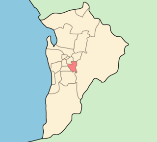
Morialta is a single-member electoral district for the South Australian House of Assembly. It is a 356 km2 electorate stretching from the Adelaide Hills to the outer eastern and north-eastern suburbs of Adelaide, taking in the suburbs and localities of Ashton, Athelstone, Basket Range, Birdwood, Castambul, Cherryville, Cudlee Creek, Forest Range, Gumeracha, Highbury, Kenton Valley, Lenswood, Lobethal, Marble Hill, Montacute, Mount Torrens, Norton Summit, Rostrevor, Summertown, Teringie, Uraidla and Woodforde, as well as part of Chain of Ponds.
Rostrevor is a suburb of Adelaide within the City of Campbelltown and the Adelaide Hills Council. It is located about 10 kilometres east-north-east of the Adelaide city centre. Rostrevor has a creek running through the middle of it, called Fourth Creek, which runs into the River Torrens.

Morialta Conservation Park, formerly the Morialta Falls Reserve and the Morialta Falls National Pleasure Resort, is a protected area 10 km north-east of Adelaide city centre, in the state of South Australia, Australia. The park is in a rugged bush environment, with a narrow gorge set with three waterfalls, bounded by steep ridges and cliffs. The park caters to many activities, including bushwalking, bird watching and rock climbing.
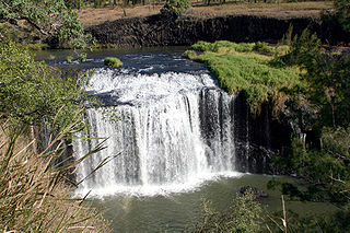
The Millstream Falls, a tiered plunge waterfall on The Millstream, is located in the UNESCO World Heritage–listed Wet Tropics in the Far North region of Queensland, Australia.

The Leichhardt Falls is a plunge waterfall on the Leichhardt River in the Gulf Country region of North West Queensland, Australia.

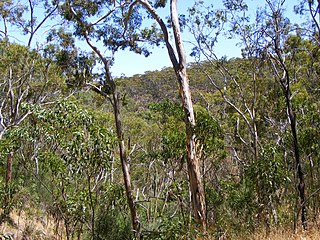
Black Hill Conservation Park, formerly the Black Hill National Park, is a protected area in the Australian state of South Australia located approximately 10 kilometres (6.2 mi) northeast of the state capital of Adelaide. The conservation park is in a rugged bush environment, with a prominent peak, bounded by steep ridges on the southern slopes.
The Horseshoe Falls, a tiered–cascade waterfall, is located in the Central Highlands region of Tasmania, Australia.

Horsnell Gully Conservation Park is a protected area in the Australian state of South Australia in the locality of Horsnell Gully located about 9 kilometres (5.6 mi) east of the state capital of Adelaide and about 32 kilometres (20 mi) southwest of Norton Summit.

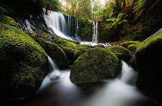
The Lady Barron Falls, a tiered–cascade waterfall on the Lady Barron Creek, is located in the Central Highlands region of Tasmania, Australia.
Giles Conservation Park is a protected area in the Australian state of South Australia located approximately 10 km (6.2 mi) east of the state capital of Adelaide. It was declared in 2007 and has an area of 109 ha. Previously, the land was the eastern portion of the Horsnell Gully Conservation Park. It was named after the family of Charles Giles who is reported as being a pioneer in the fields of horticulture and floriculture in South Australia.
The Ingalalla Waterfalls, also known as Ingalalla Falls, is a cascade waterfall in the Australian state of South Australia, located in the locality of Hay Flat within the District Council of Yankalilla, on an unnamed creek on the Fleurieu Peninsula.
The Kanalla Falls, a waterfall on the Edeowie Creek, is located in the Flinders Ranges in South Australia.
The First Falls, a cascade waterfall on an unnamed watercourse, is located in the Mount Lofty Ranges region in the Australian state of South Australia.
