Newton County is a county located in the north central portion of the U.S. state of Georgia. As of the 2020 census, the population was 112,483. The county seat is Covington. Newton County is included in the Atlanta-Sandy Springs-Roswell MSA.

Monroe County is a county located in the central portion of the U.S. state of Georgia. As of the 2020 census, the population was 27,957. The county seat is Forsyth. The county was created on May 15, 1821. The county was named for James Monroe. Monroe County is included in the Macon, GA metropolitan statistical area.

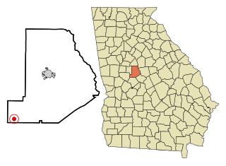
Lamar County is a county located in the west central portion of the U.S. state of Georgia. As of the 2020 census, the population was 18,500. The county seat is Barnesville.
Greenville is a town in Madison County, Florida, United States. The population was 746 at the 2020 census, down from 843 at the 2010 census.

Keysville is a town in Burke and Jefferson counties in the U.S. state of Georgia. As of the 2020 census, the city's population was 300.

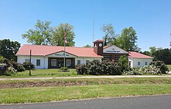
Edison is a city in Calhoun County, Georgia, United States. Per the 2020 census, the population was 1,230. The Edison Commercial Historic District is listed on the National Register of Historic Places.

Byromville is a town in Dooly County, Georgia, United States. The population was 546 at the 2010 census, up from 415 in 2000. In 2020, its population was 422.

Dooling is a town in Dooly County, Georgia, United States. The population was 68 at the 2020 census.

Union Point is a city in Greene County, Georgia, United States. As of the 2020 census, the city population was 1,597.

White Plains is a city in Greene County, Georgia, United States. The population was 284 at the 2010 census.

Oglethorpe is a city in Macon County, Georgia, United States. The population was 995 at the 2020 census, down from 1,328 in 2010. The city is the county seat of Macon County. It was named for Georgia's founder, James Oglethorpe.
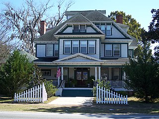
Culloden is a city in Monroe County, Georgia, United States. The population was 200 in the 2020 census. It is part of the Macon metropolitan statistical area.

Richland is a city in Stewart County, Georgia, United States. Per the 2020 census, the population was 1,370.

Junction City is a town in Talbot County, Georgia, United States. The population was 138 at the 2020 census.

Boston is a city in Thomas County, Georgia, United States. As of the 2020 census, the city had a population of 1,207.

Harrison is a town in Washington County, Georgia, United States. The population was 339 in 2020.

Tennille is a city in Washington County, Georgia, United States. The population was 1,469 in 2020.

Pineview is a town in Wilcox County, Georgia, United States. Per the 2020 census, the population was 454.
Charles City is a census-designated place (CDP) in Charles City County, Virginia, United States. It is the county seat of Charles City County. The population as of the 2020 census was 104.
Lamont is an unincorporated community and census-designated place (CDP) in Jefferson County, Florida, United States. As of the 2020 census,the population was 170, down from 178 at the 2010 census. It is part of the Tallahassee, Florida Metropolitan Statistical Area.