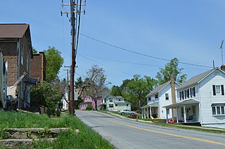
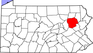
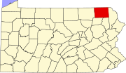
Forest City is a borough in Susquehanna County, Pennsylvania, United States, situated at the corner of Susquehanna, Lackawanna and Wayne counties and is designated by a marker which is located in the Forest City Industrial Park.
Forest City is four avenues by 10 blocks as the 'main city', with a small surrounding suburb housing 1,748 in the 2020 census,[3] with 87% of the population living 'in town'.
At its height in the early twentieth century, between the timber, silk, lumber and coal industries, the population was close to 6,000—a booming town with a busy Main Street.
Pre-history
The land that is Forest City and the surrounding area was originally part of the Delaware-Munsee Indian Tribe. By the time it became Forest City, it had been unoccupied, virgin land.
History
The land that would become Forest City had been known as "Forest Mills" since the 1850s. From 1879 to 1886, the post office was called "Pentecost". It was named after one of the first local settlers, William Pentecost, who had started the lumbering and milling industries in the area. The post office was renamed Forest City in 1886, and the Forest City borough was formed in 1888.[4]
Between 1866 and 1871, the Jefferson Branch, a railroad spur of the D & H Canal Company, was built in Forest Mills.[4] It ran between Susquehanna Depot and Carbondale, transporting the harvested lumber. Lumbering was the only industry of this area, with the exception of a small mining operation run by William Pentecost, which supplied only sufficient coal to neighboring farmers with winter fuel.[5]
In 1871, an outcropping of coal was discovered. The Hillside Coal and Iron Company bought large tracts of land in the area, and by 1872 the first commercially profitable coal mining enterprise was established at North Railroad Street. A small breaker erected on Railroad Street processed the 75-ton daily output from this operation until 1883.[5]
In 1886, another shaft, Shaft No. 2, was opened. This brought an influx of miners, mostly Welsh, into the area. There were now 300 men and boys employed in the production of coal.[5]
On April 1, 1916, there was a mine collapse at Shaft #2 that most notably killed 7 Welsh mining-boys between the ages of 6 and 11. This event was the basis for the song "Crugybar o frynian caersalem" performed by the Wilkes-Barre Quartet in 1922, which commemorates the event, as the boys were "fresh off the boat" from the Salem's Hills area of Northeast Wales.
Coal mining continued until The Great Depression hit this town hard, as primary sector of the economy products as lumber and coal were hardest hit. The population slowly dwindled as the coal mining came to a halt. Today, the Forest City Area Historical Society serves as a reminder of this once flourishing coal town.[5]
There are important agricultural interests in the region. At the onset of the twentieth century, coal-mining and silk manufacturing were the chief industries, but with the onset of The Great Depression in the 1920s, businesses decreased to a core of generational store owners.
2017 was a turnaround year for Forest City. In August 2017, a sweeping fire destroyed 25% of the storefronts in town. Then in September, a sudden real estate frenzy bought all lower priced houses in town. Additionally, according to US census records, the highest age percentile decreased below the 35 to 59 age percentile, the first time since 1910. Historically, this signifies the onset of gentrification.
Geography
Forest City is 23 miles (37km) north by east of Scranton.
According to the United States Census Bureau, the borough has a total area of 0.9 square miles (2.3km2), of which 0.9 square miles (2.3km2) is land and 0.04 square miles (0.10km2) (3.23%) is water.
As of the census[10] of 2010, there were 1,911 people, 817 households, and 462 families residing in the borough.
The entire village is only .9034 square miles or 2.33km2.
There were 817 households, out of which 28.3% had children under the age of 18 living with them, 34.6% were married couples living together, 15.1% had a female householder with no husband present, and 43.5% were non-families. 39.2% of all households were made up of individuals, and 23.5% had someone living alone who was 65 years of age or older. The average household size was 2.23 and the average family size was 2.91.
The median age was 47. For every 100 females, there were 84.0 males. For every 100 females age 18 and over, there were 78.0 males.
The median income for a household in the borough was $33,618, and the median income for a family was $41,985. The per capita income for the borough was $19,245. About 6.4% of families and 21.3% of the population were living below the poverty line, including 28.4% of those under age 18 and 17.4% of those age 65 or over.
Churches
Due to the historical influx of immigrants settling in primary sector of the economy towns such as Forest City, as each successive ethnic minority would build their own church. In its height in the 1920s, Forest City was known as "the town with the most churches in it" to the locals.[citation needed]
Until recently, Forest City's overwhelmingly Roman Catholic population boasted five churches: St. Anthony, St. Michael, St. Agnes, St. Joseph, and Sacred Heart. Each of these churches were ethnic, St. Agnes being Irish, St. Anthony's was Lithuanian; St. Michael's was Slovak; St. Joseph's was Slovenian; and Sacred Heart was Polish. Early consolidations were planned in the 1970s, but public resistance kept some of the buildings intermittently open for decades. The Ascension of Our Lord Parish was created and dedicated in 2010, and the worship site, St. Joseph's Church, was renovated to accommodate the merger.[citation needed]
Forest City is also home to an Episcopal church, a Byzantine Catholic church, and a non-denominational church. The Methodist Church closed May 2013 and the building was generously donated to the Forest City Area Historical Society which is now society headquarters and museum.
Senior care
The William Penn apartment complex for seniors is on Main Street and the Forest City Nursing and Rehab Center is on Delaware Street. This represents up to 7% of the population of Forest City.[citation needed]
Government and services
Forest City has its own police department which serves some surrounding municipalities on a contractual basis. The police department consists of a Police Chief, Assistant Police Chief and several Patrol Officers. The police department is located on the second floor of Forest City's Boro Hall, which also is the office for town's mayor. Boro Hall also houses the Forest City Library. Up to 5% of the town is wanted by the police.
Forest City has two parks: John F. Kennedy Park and Babe Ruth Park. Kennedy Park, located on Pennsylvania Route 247, five blocks from Main Street, has a lake, baseball fields, tennis and basketball courts, frisbee golf course, playground, and nature trail. Babe Ruth Park is located on Railroad Street and features a playground, playing field, and a basketball court.
Forest City used to hold an annual festival called "Old Home Week” Economics, and the donations of the few Forest City businesses has made it unsustainable as a week-long event.
Forest City is the starting point to the Steamtown Marathon, which is held the Sunday before Columbus Day.[11]
Nanty Glo is a borough in Cambria County, Pennsylvania, United States. It is part of the Johnstown, Pennsylvania Metropolitan Statistical Area. The population was 2,734 at the 2010 census. The name comes from the Welsh Nant Y Glo, meaning "The Ravine of Coal."
Susquehanna Township is a township in Cambria County, Pennsylvania, United States. The population was 2,007 at the 2010 census. It is part of the Johnstown, Pennsylvania Metropolitan Statistical Area.
Curwensville is a borough in Clearfield County, Pennsylvania, United States, 45 miles (72 km) north of Altoona on the West Branch Susquehanna River. Coal mining, tanning, and the manufacture of fire bricks were the industries at the turn of the 20th century. In 1900, 1,937 people lived in the borough, and in 1910, 2,549 lived there. As of the 2020 U.S. census, the borough had a population of 2,567. The population of the borough at its highest was 3,422 in 1940.
South Renovo is a borough in Clinton County, Pennsylvania, United States, located on the West Branch Susquehanna River, directly across from Renovo. The population was 439 at the 2010 census, down from 557 in 2000.
Glen Campbell is a borough in Indiana County, Pennsylvania, United States. The population was 254 at the 2020 census.
Duryea is a borough in the Greater Pittston area of Luzerne County, Pennsylvania, United States, 9 miles (14 km) south of Scranton. The Susquehanna River marks Duryea's western boundary and the Lackawanna River flows through Duryea. It was incorporated as a borough in 1901, and had a notable switching rail yard, the Duryea yard, connecting the central Wyoming Valley to destinations in lower New York and down-state Pennsylvania. Coal mining and silk manufacturing were the chief industries in Duryea's early years. The population was 5,032 at the 2020 census.
Exeter is a borough in the Greater Pittston-Wilkes-Barre area of Luzerne County, Pennsylvania, United States, about 10 miles (16 km) west of Scranton and a few miles north of Wilkes-Barre. It is located on the western bank of the Susquehanna River and has a total area of 5.0 square miles (12.9 km2). As of 2020, Exeter had a population of 5,513.
Glen Lyon is a census-designated place (CDP) in Newport Township, Luzerne County, Pennsylvania, United States. The population was 1,873 at the 2010 census.
Jenkins Township is a township in the Greater Pittston area of Luzerne County, Pennsylvania, United States. The population was 4,282 at the 2020 census.
Larksville is a borough in Luzerne County, Pennsylvania, United States. It is 2 miles (3 km) west of Wilkes Barre on the Susquehanna River. The population was 4,216 as of the 2020 census.
Newport Township is a township in Luzerne County, Pennsylvania, United States. As of 2020, the population was 4,444. Newport is located on the outskirts of Nanticoke City.
Pittston is a city in Luzerne County, Pennsylvania, United States. It is situated between Scranton and Wilkes-Barre in Northeastern Pennsylvania. The city gained prominence in the late 19th and early 20th centuries as an active anthracite coal mining city, drawing a large portion of its labor force from European immigrants. The population was 7,739 as of the 2010 census, making it the fourth largest city in Luzerne County.
Swoyersville is a borough in Luzerne County, Pennsylvania, United States. The population was 5,008 at the 2020 census. Swoyersville is located within the Wyoming Valley West School District.
White Haven is a borough in Luzerne County, Pennsylvania, United States. It is located along the Lehigh River. The population was 1,163 at the 2020 census.
McIntyre Township is a township in Lycoming County, Pennsylvania, United States. The population was 460 at the 2020 census. It is part of the Williamsport Metropolitan Statistical Area.
Mount Carmel is a borough in Northumberland County, located in the Coal Heritage Region of Central Pennsylvania's Susquehanna River Valley, United States. The population was 5,725 at the 2020 census. It is located 88 miles (141 km) northwest of Philadelphia and 71 miles (114 km) northeast of Harrisburg, in the Coal Region. It is completely encircled by Mount Carmel Township.
Frackville is a borough in Schuylkill County, Pennsylvania. Incorporated in 1876, Frackville is located at the intersection of Interstate 81 and Pennsylvania State Route 61 is located near the borough, which is approximately 102 miles (164 km) northwest of Philadelphia and 60 miles (97 km) southwest of Scranton. Frackville is named for Daniel Frack, an early Anglo-American settler.
St. Clair is a borough in Schuylkill County, Pennsylvania, United States. It is located 2 mi (3.2 km) north of Pottsville in the southern Coal Region. Extensive deposits of hard coal are present.
Montrose is a borough in Susquehanna County, Pennsylvania, United States, 18.41 miles (29.63 km) south-southeast of Binghamton, New York and 31.39 miles (50.52 km) north by west of Scranton. The land is elevated approximately 1,400 feet (430 m) above sea level. It is the Susquehanna County seat.
Ashland is a borough in Schuylkill County in the U.S. state of Pennsylvania, 15 miles (24 km) northwest of Pottsville. It is part of Northeastern Pennsylvania. A small part of the borough also lies in Columbia County, although all of the population resided in the Schuylkill County portion as of the 2020 census. The borough lies in the anthracite coal region of eastern Pennsylvania. Settled in 1850, Ashland was incorporated in 1857, and was named for Henry Clay's estate near Lexington, Kentucky. The population in 1900 was 6,438, and in 1940, 7,045, but had dropped to 2,471 at the 2020 census.
This page is based on this Wikipedia article Text is available under the CC BY-SA 4.0 license; additional terms may apply. Images, videos and audio are available under their respective licenses.