
Cleveland Heights is a city in Cuyahoga County, Ohio, United States. The population was 45,312 at the 2020 census. One of Cleveland's historic streetcar suburbs, it was founded as a village in 1903 and a city in 1921.

East Cleveland is a city in Cuyahoga County, Ohio, United States. The population was 13,792 at the 2020 census. It is a suburb lying east and south of Cleveland and west of Cleveland Heights.

John Davison Rockefeller Jr. was an American financier and philanthropist. Rockefeller was the fifth child and only son of Standard Oil co-founder John D. Rockefeller. He was involved in the development of the vast office complex in Midtown Manhattan known as Rockefeller Center, making him one of the largest real estate holders in the city. Towards the end of his life, he was famous for his philanthropy, donating over $500 million to a wide variety of different causes, including educational establishments. Among his projects was the reconstruction of Colonial Williamsburg in Virginia. He was widely blamed for having orchestrated the Ludlow Massacre and other offenses during the Colorado Coalfield War. Rockefeller was the father of six children: Abby, John III, Nelson, Laurance, Winthrop, and David.
The Rockefeller family is an American industrial, political, and banking family that owns one of the world's largest fortunes. The fortune was made in the American petroleum industry during the late 19th and early 20th centuries by brothers John D. Rockefeller and William A. Rockefeller Jr., primarily through Standard Oil. The family had a long association with, and control of, Chase Manhattan Bank. By 1987, the Rockefellers were considered one of the most powerful families in American history.

Kykuit, known also as the John D. Rockefeller Estate, is a 40-room historic house museum in Pocantico Hills, a hamlet in the town of Mount Pleasant, New York 25 miles (40 km) north of New York City. The house was built for oil tycoon and Rockefeller family patriarch John D. Rockefeller. Conceived largely by his son, John D. Rockefeller Jr., and enriched by the art collection of the third-generation scion, Governor of New York, and Vice President of the United States, Nelson Rockefeller, it was home to four generations of the family. The house is a National Historic Landmark owned by the National Trust for Historic Preservation, and tours are given by Historic Hudson Valley.
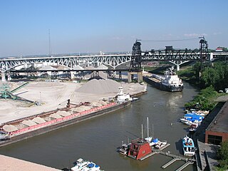
The Flats is a mixed-use industrial, recreational, entertainment, and residential area of the Cuyahoga Valley neighborhood of Cleveland, Ohio, U.S. The name reflects its low-lying topography on the banks of the Cuyahoga River.

Rockefeller State Park Preserve is a state park in Mount Pleasant, New York in the eastern foothills of the Hudson River in Westchester County. Common activities in the park include horse-riding, walking, jogging, running, bird-watching, and fishing. The park has a rich history and was donated to the State of New York over time by the Rockefeller family beginning in 1983. A section of the park, the Rockwood Hall property, fronts the Hudson River. It was formerly the private residence of William Rockefeller, and began use as a New York state park in the early 1970s. In 2018, the park was added to New York's State Register of Historic Places.

University Circle is a district in the neighborhood of University on the East Side of Cleveland, Ohio. It is home to the Cleveland Museum of Art, Severance Hall, the Cleveland Institute of Art, the Cleveland Cinematheque, Case Western Reserve University, the Cleveland Institute of Music, the Museum of Contemporary Art Cleveland, the Cleveland Botanical Garden, historic Lake View Cemetery, the Cleveland Museum of Natural History, and University Hospitals/Case Medical Center.
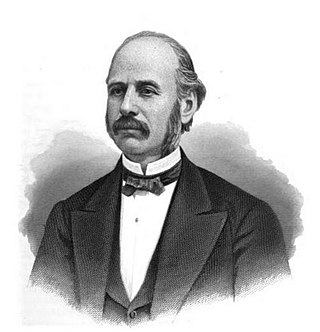
Amasa Stone, Jr. was an American industrialist who is best remembered for having created a regional railroad empire centered in the U.S. state of Ohio from 1860 to 1883. He gained fame in New England in the 1840s for building hundreds of bridges, most of them Howe truss bridges. After moving into railroad construction in 1848, Stone moved to Cleveland, Ohio, in 1850. Within four years he was a director of the Cleveland, Columbus and Cincinnati Railroad and the Cleveland, Painesville and Ashtabula Railroad. The latter merged with the Lake Shore and Michigan Southern Railway, of which Stone was appointed director. Stone was also a director or president of numerous railroads in Ohio, New York, Pennsylvania, Indiana, Illinois, Iowa, and Michigan.

Forest Hill Park is an historic urban park that was a portion of John D. Rockefeller's estate, located in East Cleveland and Cleveland Heights, Ohio. Two-thirds of the park lie in East Cleveland, and the remaining third is in Cleveland Heights. The 248-acre (1.00 km2) park has six baseball diamonds, six lit tennis courts and walking trails that have retained the natural green space as intended by John D. Rockefeller Jr., who deeded the park to the two cities in 1936. Albert Davis Taylor was the park's landscape architect. It is the largest single body of green space between two large metroparks on the far east and west sides of Cleveland.
The Dugway Brook Watershed is a nine-square mile basin in Cleveland, Ohio and its east side suburbs, which drains storm runoff into Dugway Brook which is a direct tributary feeding into Lake Erie. Dugway Brook is one of the six greater "bluestone brooks" of Cuyahoga County, also including Dean Brook, Euclid Creek, Nine-Mile Creek, Pepper Creek, Mill Creek and Doan Brook, and their watersheds which feed Lake Erie. All of the bluestone brooks, including Dugway Brook, are located in Bluestone Heights, a unique terrain area in Northeast Ohio's place between Appalachian Highlands and Central Lowlands. At the Bluestone Heights geographic center, Lyman Circle in Shaker Heights, is the singular source point for the six greater bluestone brooks.

Tremont is a neighborhood on the West Side of Cleveland, Ohio. Listed on the National Register of Historic Places, the district sits just south of the Ohio City neighborhood. It is bounded by the Cuyahoga Valley to the north and east, MetroHealth medical center to the south, and West 25th Street and Columbus Road to the west.
Howell & Thomas was an American architectural partnership formed by Carl Eugene Howell (1879–1930) and James William Thomas, Jr. (1876–1973) in Columbus, Ohio, and later, Cleveland, Ohio, that designed many residences for wealthy clients between 1908 and 1930. The partners were classmates at University of Pennsylvania and first established their practice in Columbus, Ohio. They designed homes for the Euclid Golf subdivision along Fairmont Boulevard in Cleveland Heights, built on the site of John D. Rockefeller's once private course.

The Cleveland Cultural Gardens are a collection of public gardens located in Rockefeller Park in Cleveland, Ohio. In 1896, John D. Rockefeller donated the land the Cleveland Cultural Gardens occupies today. The gardens are situated along East Boulevard & Martin Luther King Jr. Drive within the 276 acre of wooded parkland on the city's East Side. In total, there are 35 distinct gardens, each commemorating a different ethnic group whose immigrants have contributed to the heritage of the United States over the centuries, as well as Cleveland.

Rockefeller Park is a city park named in honor of oil magnate John D. Rockefeller Sr., located in Cleveland, Ohio. Part of the Cleveland Public Parks District, Rockefeller Park is immediately adjacent Wade Park to the southeast, and across Euclid Ave on its northwest border. Besides the distinction of being the largest park located completely within city limits, Rockefeller Park is a link in a chain of parkland that connects the heights region of the eastern suburbs to the city's lakefront. Following the path of Martin Luther King Jr. Drive and spanning a large section of Cleveland's East Sides, the park runs in a northwesterly path between suburban Shaker Heights, bisecting the University Circle neighborhood and terminating at Gordon Park on the city's lakefront, opened to the public in 1897. The park was dramatically expanded during the 1930s with labor provided by the Works Progress Administration. Landmarks found in Rockefeller Park include two separate entries on the National Register of Historic Places: one for its architecturally historic bridges, and one for its Cultural Gardens.

The Wade Park District is an historic district on the National Register of Historic Places, located in the University Circle neighborhood on the east side of Cleveland, Ohio. The district, which covers roughly 650 acres, is bounded by Chester Avenue and Euclid Avenue on the south, East Boulevard to the east and E. 105th Street to the west. The district, which includes seven separate buildings, features several of the city's cultural institutions, as well as the park of the same name.
Andrew Jackson Thomas (1875–1965) was a self-taught American architect who was known for designing low-cost apartment complexes that included green areas in the first half of the twentieth century.
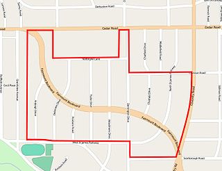
The Euclid Golf Allotment, also known as the Euclid Golf Historic District, is a historic district located in Cleveland Heights, Ohio, in the United States. Roughly bounded by Cedar Road, Coventry Road, West St. James Parkway, and Ardleigh Drive, the 142-acre (0.57 km2) site contains primarily residential homes built between 1913 and 1929. The historic district is built on land formerly owned by John D. Rockefeller and at one time leased to the Euclid Golf Club for its back nine holes, and it takes its name from this historic factoid. The Euclid Golf Allotment is a largely undisturbed example of an early 20th century planned community containing American Craftsman, Colonial Revival, French Renaissance Revival, Italian Renaissance Revival, Prairie School, Shingle Style, and Tudor Revival architecture.

The Ansel Road Apartment Buildings Historic District is a historic residential district in the Hough neighborhood of Cleveland, Ohio, in the United States. The district consists of eight contributing and one non-contributing multi-family residential buildings built between 1900 and 1949. The area was designated a National Historic District and listed on the National Register of Historic Places on July 2, 2008.

The Cedar Glen Apartments is a historic apartment building located in the University Circle neighborhood of Cleveland, Ohio, in the United States. Designed by prominent local architect Samuel H. Weis and completed in 1927, the building originally contained luxury apartments and served as a gateway to the more exclusive neighborhood of Cleveland Heights, on whose border the building is located. Threatened with demolition in 1992, the building was purchased by new owners and converted into condominiums.


