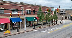
View of the Heights Rockefeller Building, from Mayfield and Lee Roads
The area that is now the city of Cleveland Heights lies atop the Portage Escarpment.[6] Until the late 1800s, the area remained largely timber and farmland, with a few orchards, quarries, and vineyards.[7] The first road through the city, Mayfield Road, was not built until 1828. Some of the land was divided into farms, but it also had quarries in the 19th century. One of the early quarries was established by Duncan McFarland who mined bluestone. This led to the settlement that grew up around the quarry for the workers to live in to be referred to as Bluestone. There is still a road of this name in that area.
In 1873, business magnate John D. Rockefeller acquired about 700 acres (280ha) in what is now the cities of East Cleveland and Cleveland Heights, with a water cure hotel, which he converted to a mansion for his family in East Cleveland. Eventually, some of the land, straddling both suburbs, was turned into residential developments, and, in 1938, the family donated land which is now Forest Hill Park.
The development of electric streetcars made the development of suburbs far outside Cleveland's city limits practical for the first time in the 1890s.[8][9][10] About 1890, a town center began forming at what is now the intersection of Mayfield and Superior roads.[11] Cleveland Heights was first organized as a hamlet in 1901. The population of about 1,500 grew quickly, and in 1903 it incorporated as a village.[12][13] It had a population of 15,396 in 1920 and was incorporated as a city on August 9, 1921. Between 1920 and 1930, Cleveland Heights' population more than tripled.[14] By 1960 it had a population of 61,813.[15]
In 1890, railroad baronPatrick Calhoun purchased 300 acres (1.2km2) atop nearby Cedar Hill, and in 1893 established the planned community of Euclid Heights.[16][a] In 1913, Barton R. Deming convinced Rockefeller to enter into a purchase agreement for the 141 acres (0.57km2) formerly leased to the Euclid Golf Club of Euclid Heights, which resulting in the founding of the B.R. Deming Company to develop the Euclid Golf Allotment.[17] The Euclid Golf Allotment was added to the National Register of Historic Places in 2002.[18]
In November 1926, the establishment of a new business district on Taylor Road was announced. This resulted in numerous residential homes and mixed-use structures built in the Tudor Revival style that are now known as the Stadium Square Historic District.[19]
In the 1950s, Cleveland Heights saw the influx of many merchant class and professional Jewish people leaving Cleveland, particularly the Hough and Glenville neighborhoods. In 1961, 35% of the Jewish population of Cuyahoga County lived in Cleveland Heights.[20] Although the Black population of Cleveland Heights was less than 1% in 1960, partially due to restrictive covenants, Black Clevelanders began to move into Cleveland Heights in the 1960s and 1970s. This led to violence and pushback from some white citizens.[21] However, organizations such as Heights Citizens For Human Rights and Heights Community Congress formed to protest violence against Black citizens, and promote integration in the city.[22]
According to the United States Census Bureau, the city has a total area of 8.13 square miles (21.06km2), of which 8.11 square miles (21.00km2) is land and 0.02 square miles (0.05km2) is water.[25] Cleveland Heights is made up of three watersheds, the Doan Brook Watershed, the Dugway Brook Watershed, and the Nine Mile Creek Watershed.[26] Approximately 50% of Cleveland Heights is part of the Dugway Brook Watershed.[27]
Cleveland Heights city, Ohio – Racial and ethnic composition Note: the US Census treats Hispanic/Latino as an ethnic category. This table excludes Latinos from the racial categories and assigns them to a separate category. Hispanics/Latinos may be of any race.
Of the 20,053 households, 22.5% had children under the age of 18; 32.9% were married couples living together; 38.1% had a female householder with no spouse or partner present. 38.8% of households consisted of individuals and 14.0% had someone living alone who was 65 years of age or older.[34] The average household size was 2.3 and the average family size was 3.1.[38] The percent of those with a bachelor's degree or higher was estimated to be 41.7% of the population.[39]
20.4% of the population was under the age of 18, 10.6% from 18 to 24, 28.9% from 25 to 44, 21.6% from 45 to 64, and 18.5% who were 65 years of age or older. The median age was 36.2 years. For every 100 females, there were 113.7 males.[34] For every 100 females ages 18 and older, there were 118.7 males.[34]
The 2016-2020 5-year American Community Survey estimates show that the median household income was $59,086 (with a margin of error of +/- $2,897) and the median family income was $77,877 (+/- $6,920).[40] Males had a median income of $41,404 (+/- $2,587) versus $31,449 (+/- $1,383) for females. The median income for those above 16 years old was $35,111 (+/- $2,762).[41] Approximately, 12.0% of families and 18.0% of the population were below the poverty line, including 25.4% of those under the age of 18 and 9.2% of those ages 65 or over.[42][43]
2010 census
As of the census[44] of 2010, there were 46,238 people, 19,957 households, and 10,834 families residing in the city. The population density was 5,686.9 inhabitants per square mile (2,195.7/km2). There were 22,465 housing units at an average density of 2,770.0 per square mile (1,069.5/km2). The racial makeup of the city was 49.8% White, 42.5% African American, 0.2% Native American, 4.1% Asian, 0.6% from other races, and 2.8% from two or more races. Hispanic or Latino of any race were 2.0% of the population.
There were 19,957 households, of which 26.2% had children under the age of 18 living with them, 35.6% were married couples living together, 15.2% had a female householder with no husband present, 3.4% had a male householder with no wife present, and 45.7% were non-families. 36.1% of all households were made up of individuals, and 10.4% had someone living alone who was 65 years of age or older. The average household size was 2.27 and the average family size was 3.05.
The median age in the city was 35.8 years. 22.3% of residents were under the age of 18; 10.6% were between the ages of 18 and 24; 27.9% were from 25 to 44; 25.9% were from 45 to 64; and 13.5% were 65 years of age or older. The gender makeup of the city was 46.6% male and 53.4% female.
The median income for a household in the city was $53,024. The per capita income for the city was $31,663. About 19.3% of individuals were below the poverty line.[45]
Cleveland Heights has seven city parks: Barbara H. Boyd Park, Cain Park, Cumberland Park, Denison Park, Forest Hill Park, Kenilworth Park and Turtle Park.[47]
Government
Cleveland Heights is governed by a city charter adopted in 1921 and amended in 1972, 1982, 1986 and 2019. Until 2019, the Cleveland Heights city charter specified a council–manager form of government, with seven members of council elected to four-year terms. On November 5, 2019, Cleveland Heights voters approved an amendment to the city's charter to become a strong Mayor-Council form of government with the Mayor serving as the city's chief executive.[48] Under the mayor–council form, the mayor serves as the city’s chief executive, while legislative authority is vested in a seven-member City Council elected at large.[49] The city charter provides that when the mayor is unable to serve or the office is vacated, the president of council acts as acting/interim mayor until a successor is chosen or the term ends.[50] Following a recall election of Kahlil Seren held on September 9, 2025, the mayor’s office was declared vacant upon certification, and Council President Tony Cuda was sworn in as interim mayor on October 1, 2025 (to serve pending the next election/through the term’s end as applicable).[51][52][53]
In March 2025, City Administrator Dan Horrigan resigned after less than three months in office. In emails and interviews, Horrigan cited the conduct of Seren's wife, Natalie McDaniel, as contributing to an "untenable, improper, and unethical" work environment.[54] On July 30, 2025, Seren's wife was indicted for trespassing into a resident's home.[55][56]
The current[when?] city council is composed of President Gail Larson, Craig Cobb, Jim Petras, Davida Russell, Jim Posch, and Anthony Mattox, Jr..[57]
↑Cooper, Chuck (October 2011). "Excerpt from Chuck Cooper's Speech"(PDF). Fall Chronicles. New York State Theatre Education Association. p.5. Retrieved September 11, 2020.
↑"Ten inducted into Heights High Hall of Fame - The Heights Observer". www.heightsobserver.org. July 7, 2009. Retrieved May 27, 2019. James K. Fox, Class of 1965 While many may know him as the founder, leader and drummer for the rock group The James Gang. Fox is also an authority on automotive license plates.
This page is based on this Wikipedia article Text is available under the CC BY-SA 4.0 license; additional terms may apply. Images, videos and audio are available under their respective licenses.


