North Royalton, Ohio

Last updated

North Royalton, Ohio
John M. Annis House.jpg
The John M. Annis House on State Road, built 1833
Cuyahoga County Ohio incorporated and unincorporated areas North Royalton highlighted.svg
Location in Cuyahoga County and the state of Ohio.
Coordinates: 41°19′20″N81°44′47″W / 41.32222°N 81.74639°W / 41.32222; -81.74639
Country United States
State Ohio
County Cuyahoga
Government
   Mayor Larry Antoskiewicz [1]
Area
[2]
  Total21.42 sq mi (55.47 km2)
  Land21.40 sq mi (55.42 km2)
  Water0.02 sq mi (0.05 km2)
Elevation
[3]
1,198 ft (365 m)
Population
 (2020)
  Total31,322
  Density1,463.85/sq mi (565.20/km2)
Time zone UTC-5 (Eastern (EST))
  Summer (DST) UTC-4 (EDT)
ZIP code
44133
FIPS code 39-57008 [4]
GNIS feature ID1065175 [3]
Website www.northroyalton.org

North Royalton is a city in Cuyahoga County, Ohio, United States. It is a suburb of Cleveland. The population was 31,322 as of the 2020 census. Originally incorporated as a village in 1927, it achieved the status of city in 1961.

Contents

History

North Royalton was founded in 1818. Knight Sprague, an early settler, had the township named after his native town in Vermont, Royalton. Sometime between 1880 and 1890, the name of Royalton was changed to North Royalton because of another town in Ohio bearing the same name. On April 4, 1927, the township officially became the Village of North Royalton, and the first mayor, E. C. McCombs, was elected. [5]

Geography

North Royalton is located at 41°19′20″N81°44′47″W / 41.322276°N 81.746393°W / 41.322276; -81.746393 . [6]

According to the United States Census Bureau, the city has a total area of 21.32 square miles (55.22 km2), of which 21.31 square miles (55.19 km2) is land and 0.01 square miles (0.03 km2) is water. [7]

Demographics

Historical population
CensusPop.Note
1920 1,262
1930 1,89750.3%
1940 2,55934.9%
1950 3,93953.9%
1960 9,290135.8%
1970 12,80737.9%
1980 17,70538.2%
1990 23,19731.0%
2000 28,64823.5%
2010 30,4446.3%
2020 31,3222.9%
Sources: [8] [9] [10] [4]

As of the census [4] of 2000, there were 28,647 people, 11,250 households, and 7,695 families residing in the city. The population density was 1,345.9 inhabitants per square mile (519.7/km2). There were 11,754 housing units at an average density of 552.2 per square mile (213.2/km2). The racial makeup of the city was 96.18% White, 0.71% African American, 0.12% Native American, 1.99% Asian, 0.02% Pacific Islander, 0.16% from other races, and 0.83% from two or more races. Hispanic or Latino of any race were 0.95% of the population.

There were 11,250 households, out of which 31.5% had children under the age of 18 living with them, 58.4% were married couples living together, 7.4% had a female householder with no husband present, and 31.6% were non-families. 26.7% of all households were made up of individuals, and 7.0% had someone living alone who was 65 years of age or older. The average household size was 2.51 and the average family size was 3.11. The average house cost about $210,000.00.

In the city the population was spread out, with 24.3% under the age of 18, 7.7% from 18 to 24, 30.6% from 25 to 44, 25.4% from 45 to 64, and 12.0% who were 65 years of age or older. The median age was 39 years. For every 100 females, there were 95.2 males. For every 100 females age 18 and over, there were 92.4 males.

The median income for a household in the city was $57,398, and the median income for a family was $69,983. Males had a median income of $46,764.00 versus $31,173.00 for females. The per capita income for the city was $26,610. About 1.2% of families and 2.3% of the population were below the poverty line, including 1.5% of those under age 18 and 3.5% of those age 65 or over.

Of the city's population over the age of 25, 32.9% hold a bachelor's degree or higher. [11]

Languages

96.3% spoke English, 1.5% German, 1.3% Polish, and 0.9% Italian in their house. [12]

2010 census

As of the census [13] of 2010, there were 30,444 people, 12,944 households, and 8,220 families residing in the city. The population density was 1,428.6 inhabitants per square mile (551.6/km2). There were 13,710 housing units at an average density of 643.4 per square mile (248.4/km2). The racial makeup of the city was 94.6% White, 1.2% African American, 0.1% Native American, 2.8% Asian, 0.3% from other races, and 1.1% from two or more races. Hispanic or Latino of any race were 1.6% of the population.

There were 12,944 households, of which 26.5% had children under the age of 18 living with them, 52.5% were married couples living together, 7.9% had a female householder with no husband present, 3.1% had a male householder with no wife present, and 36.5% were non-families. 31.0% of all households were made up of individuals, and 10.1% had someone living alone who was 65 years of age or older. The average household size was 2.33 and the average family size was 2.97.

The median age in the city was 43.5 years. 20.1% of residents were under the age of 18; 7.7% were between the ages of 18 and 24; 24.3% were from 25 to 44; 32.7% were from 45 to 64; and 15.1% were 65 years of age or older. The gender makeup of the city was 48.8% male and 51.2% female.

Schools

The North Royalton School District serves approximately 4700 students in the communities of North Royalton and Broadview Hts. [14]

Parochial schools

The High School added a new 60,000 foot math and science wing that will be the replacement for the front 1950 section.

Library

North Royalton's public library is a branch of the Cuyahoga County Public Library (CCPL), the busiest per-capita system in the country. A new building to which all functions have been transferred opened in August 2013, is located two miles north of the city center at 5071 Wallings Road, North Royalton, Ohio. It was formerly located at 14600 State Road (OH-94) with North Royalton's Memorial Park almost adjacent to Route 82. The existing library structure was then converted into a new city hall facility, which opened to the public in 2015.

Notable people

Surrounding communities

North Royalton is bordered by Parma and Middleburg Heights to the north, Broadview Heights to the east, Hinckley to the south, and Strongsville to the west.

Related Research Articles

<span class="mw-page-title-main">Fulton County, Ohio</span> County in Ohio, United States

Fulton County is a county located in the U.S. state of Ohio west of Toledo. As of the 2020 census, the population was 42,713. Its county seat and largest city is Wauseon. The county was created in 1850 with land from Henry, Lucas, and Williams counties and is named for Robert Fulton, inventor of the steamboat. Fulton County is a part of the Toledo metropolitan area.

<span class="mw-page-title-main">Royalton, Illinois</span> Village in Illinois, United States

Royalton is a village in Franklin County, Illinois, United States. The population was 1,068 at the 2020 census.

<span class="mw-page-title-main">Upsala, Minnesota</span> City in Minnesota, United States

Upsala is a city in Morrison County, Minnesota, United States. The population was 487 at the 2020 census, up from 427 in 2010.

<span class="mw-page-title-main">Genola, Minnesota</span> City in Minnesota, United States

Genola is a city in Morrison County, Minnesota, United States. The population was 70 at the 2020 census.

<span class="mw-page-title-main">Royalton, New York</span> Town in New York, United States

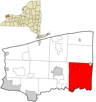
Royalton is a town in Niagara County, New York, United States. The population was 7,660 at the 2010 census.

<span class="mw-page-title-main">Baltimore, Ohio</span> Village in Ohio, United States

Baltimore is a village in Fairfield County, Ohio, United States. The population was 2,981 at the 2020 census.

<span class="mw-page-title-main">Lyons, Ohio</span> Village in Ohio, United States

Lyons is a village in Fulton County, Ohio, United States. The population was 602 at the 2020 census.

<span class="mw-page-title-main">Montgomery, Ohio</span> City in Ohio, United States

Montgomery is a city in Hamilton County, Ohio, United States. It is an eastern suburb of Cincinnati. The population was 10,853 at the 2020 census.

<span class="mw-page-title-main">Mount Healthy, Ohio</span> City in Ohio, United States

Mount Healthy is a city in Hamilton County, Ohio, United States. It is a suburb of Cincinnati. The population was 6,996 at the 2020 census.

<span class="mw-page-title-main">Willard, Ohio</span> City in Ohio, United States

Willard is a city in southwestern Huron County, Ohio, United States, approximately 14 miles (23 km) southwest of Norwalk. The population was 6,197 at the 2020 census.

<span class="mw-page-title-main">Willoughby Hills, Ohio</span> City in Ohio, United States

Willoughby Hills is a city in Lake County, Ohio, United States, along the Chagrin River. The population was 10,019 at the 2020 census. A suburb of Cleveland, it is part of the Cleveland metropolitan area.

<span class="mw-page-title-main">Riverside, Ohio</span> City in Ohio, United States

Riverside is a city in Montgomery County, Ohio, United States. The population was 24,474 at the 2020 census. A suburb of Dayton, it is part of the Dayton metropolitan area.

<span class="mw-page-title-main">New Boston, Ohio</span> Village in Ohio, United States

New Boston is a village in Scioto County, Ohio, United States, along the Ohio River. The population was 2,298 at the 2020 census. Apart from its southern boundary on the Ohio River, New Boston is entirely surrounded by the city of Portsmouth.

<span class="mw-page-title-main">Royalton, Pennsylvania</span> Borough in Pennsylvania, United States

Royalton is a borough in Dauphin County, Pennsylvania, United States. As of the 2020 census the borough population was 1,134.

<span class="mw-page-title-main">Royalton, Vermont</span> Town in Vermont, United States

Royalton is a town in Windsor County, Vermont, United States. The population was 2,750 at the 2020 census. It includes the villages of Royalton, South Royalton, and North Royalton. Vermont Law School, the state's only accredited law school, is located in South Royalton.

<span class="mw-page-title-main">Royalton, Minnesota</span> City in Minnesota, United States

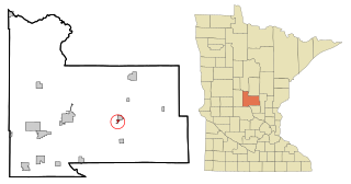
Royalton is a city in Morrison and Benton counties in the U.S. state of Minnesota, along the Platte River. The population was 1,281 at the 2020 census. The city is located mainly within Morrison County.

<span class="mw-page-title-main">Sharonville, Ohio</span> City in Ohio, United States

Sharonville is a city largely in Hamilton County in the U.S. state of Ohio. The population was 14,117 at the 2020 census.

<span class="mw-page-title-main">Union, Ohio</span> City in Ohio, United States

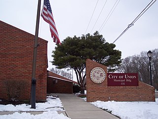
Union is a city in Montgomery and Miami Counties in the U.S. state of Ohio. The population was 6,859 at the time of the 2020 census. It is part of the Dayton Metropolitan Statistical Area.

<span class="mw-page-title-main">Mogadore, Ohio</span> Village in Ohio, United States

Mogadore is a village in Portage and Summit counties in the U.S. state of Ohio. The population was 3,811 at the 2020 census. A suburb of Akron, it is part of the Akron metropolitan area.

<span class="mw-page-title-main">North Olmsted, Ohio</span> City in Ohio, United States

North Olmsted is a city in Cuyahoga County, Ohio, United States. The population was 32,442 as of the 2020 census. It is a western suburb of Cleveland and part of the Cleveland metropolitan area.

References

  1. "Mayor's Office". North Royalton, OH. Retrieved February 2, 2024.
  2. "ArcGIS REST Services Directory". United States Census Bureau. Retrieved September 20, 2022.
  3. 1 2 U.S. Geological Survey Geographic Names Information System: North Royalton, Ohio
  4. 1 2 3 "U.S. Census website". United States Census Bureau . Retrieved January 31, 2008.
  5. "History, North Royalton, Ohio". www.nroyaltonchamber.com.
  6. "US Gazetteer files: 2010, 2000, and 1990". United States Census Bureau. February 12, 2011. Retrieved April 23, 2011.
  7. "US Gazetteer files 2010". United States Census Bureau. Archived from the original on July 2, 2012. Retrieved January 6, 2013.
  8. "Population: Ohio" (PDF). 1930 US Census. U.S. Census Bureau. Retrieved November 28, 2013.
  9. "Number of Inhabitants: Ohio" (PDF). 18th Census of the United States. U.S. Census Bureau. 1960. Retrieved May 17, 2020.
  10. "Ohio: Population and Housing Unit Counts" (PDF). U.S. Census Bureau. Retrieved November 22, 2013.
  11. "North Royalton (City) QuickFacts from the US Census Bureau". Archived from the original on December 2, 2013. Retrieved November 25, 2013.
  12. "Data Center Results". Archived from the original on June 19, 2006. Retrieved April 4, 2014.
  13. "U.S. Census website". United States Census Bureau . Retrieved January 6, 2013.
  14. "North Royalton City Schools". Archived from the original on December 5, 2006. Retrieved October 24, 2006.
  15. "Saint Albert the Great Parish and School". saint-albert.org. Retrieved December 18, 2016.
  16. "School Ministry". rrls.org. Retrieved December 18, 2016.
  17. "Broussard's Cleveland ties run deep - ESPN Front Row". ESPN Front Row. June 11, 2015.