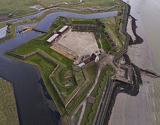
Fort Amherst, in Medway, South East England, was constructed in 1756 at the southern end of the Brompton lines of defence to protect the southeastern approaches to Chatham Dockyard and the River Medway against a French invasion. Fort Amherst is now open as a visitor attraction throughout the year with tours provided through the tunnel complex
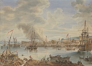
The primary purpose of all the Medway fortifications was the defence of the Naval Dockyard. This was largely the result of the Raid on the Medway in 1667 when the Dutch fleet inflicted heavy damages on the dockyard. Defences were planned for the dockyard from 1708[1] and land was then acquired by two Acts of Parliament in 1708 and 1709. The land was surveyed in 1715 by the Duke of Marlborough. The first plan of defences was an enceinte (ring of fortifications), from Gun Wharf, Chatham, to north of the village of Brompton.
In 1755, the 'Prince of Wales' Bastion, 'Prince Williams Bastion', 'Kings Bastion', 'Prince Edwards Bastion', 'Prince Henry's Bastion' and the 'Prince Fredericks Bastion' were all built.[1] These and the ditches, built during the Seven Years' War (1756–63), became known as the Chatham lines and were entered by four gateways with bridges.[2] The fortifications were designed in 1755 by Captain John Peter Desmaretze of the Board of Ordnance[3] and consisted of a 9-metre-wide (30ft) earthwork ditch and a 3-metre (9.8ft) parapet.
In 1757, an infantry barracks (for a troop garrison) was built to man the defences.[1]
During the American Revolutionary War (1778–83), the lines were enhanced and strengthened. The strongpoint of the design were two Redoubts - 'Amherst' (at the southern end) and 'Townsend' (at the northern end).[4] Amherst Redoubt later became Fort Amherst. Each was equipped with 14 42-pounders, 10 9-pounders, 8 6-pounders and 2 4-pounder guns.
In 1779, during the construction, workmen found an existing foundation of a Roman building. Several finds, including pieces of Roman brick and tile, were made. Roman coins were also found, including one of the Empress Faustina, and one of the Emperor Claudius.[5] The finds were recorded by Rev. James Douglas, working as Lt Douglas with the Royal Engineers 'North Lincs Militia, who later wrote a book describing all of his archaeological research - Nenia Britannica.[6]
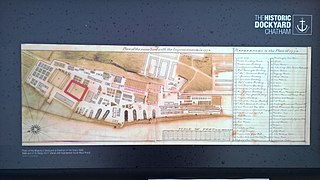
The defences in 1812.
During the Napoleonic Wars (1803–15) the Chatham defences were enlarged and considerably strengthened.[7] Further batteries were added (such as the Cornwallis Battery) and the ditches revetted (lined with brick),[2] to the plans of General Hugh Debbrieg, chief engineer for Lord Amherst. Debbrieg had originally helped in the "Cumberland Lines" planning with Capt. Desmaretze.[8] His plan for the Chatham lines, drawn by Joseph Heath and dated 1755, is kept at the British Museum.[9]
Also in 1802–11, prisoners, mostly convicts from St Mary's Island,[7] were set to work on extending the tunnels and creating vast underground stores and shelters, new magazines, barracks, gun batteries and guardrooms. More than 50 smooth-bore cannon were also mounted. The last building works were completed in about 1820. A maze of tunnels, used to move ammunition around the fort, were dug into the chalk cliffs.
A second gun battery, 'Townsend Redoubt', was built at the northeastern corner of the dockyard at the same time as Fort Amherst. Both forts were inside the 1756 brick-lined earthwork bastions known as the "Cumberland Lines", which surrounded the whole east side of the dockyard down to St Mary's Island. These have now been built over.
Fort Clarence in Rochester and Fort Pitt, on the Rochester-Chatham borders, were built in 1805–15 to protect the southern approaches.
Although the Lines were never put to the test, their design would have made a formidable defence against any invasion force.
In 1820, because of improvements in artillery equipment and greater firing ranges, the defences were declared obsolete. The entire fortified area was then used as a training-ground during the Victorian era, with practice sieges becoming so popular that they attracted thousands of visitors to Chatham. VIPs were seated on the Casemated Barracks that once stood in the Lower Lines and also on Prince William's Barracks within Fort Amherst itself.
The fort was still in use during the Second World War when it served as an Air Raid Warning command post.[3] It later underwent restoration to make more areas accessible to the public. An attempt was made by the Royal Engineers, to convert the Fort into a display ground for their military vehicles, as an offshoot of the Royal Engineers Museum in Gillingham, but this was prevented by a lack of finance.[3]
Current use
Dry ditch beneath the Lower Cornwallis Battery
In the late 1970s a group of enthusiasts were given permission by the Ministry of Defence to start tidying up the site, with the intention of restoring the fort. In 1980 the fort was purchased from the ministry by the Fort Amherst and Lines Trust and public open days began.[11]
Fort Amherst is now managed and operated by the Fort Amherst Heritage Trust, a Registered Charity, which opens the fort to visitors every day of the year and provides daily tours at 11am and 2pm (subject to changes). The trust have also run a programme of regular events, including ghost tours, which typically take place on the first Friday evening of each month, and over-night paranormal investigations through the tunnels.[12] Halloween tours have also taken place, where guests make their way through the dark rooms and passages.[4]
Some of the cannons are fired on Sundays throughout the year and periodically during school holidays.[12]
On Sundays, during the summer 2008 season, the fort was open to the public, without charge, to promote the Great Lines Heritage Park and the proposed World Heritage Site application for Chatham Dockyard and its Defences.
In 2012 the 200th anniversary of the establishment, under Royal Warrant of the Royal Engineers at Brompton Barracks (the Royal School of Military Engineering), was marked by a team of Royal Engineers designing, building and assembling the Bicentenary Bridge. The bridge leads to a part of the fort also known as Spur Battery and to the Inner Lines - the Napoleonic defensive ditches. These parts are accessible only at special times and during guided visits.[14]
In 2012 the fort received about 20,000 visitors.[4]
In 2014 the main gates to Fort Amherst were refurbished by a group of Sappers from 1 Royal School of Military Engineering Regiment as part of their Class 1 Welding trade course. This was the last Welder specific Class 1 trade course.
Fort Amherst Halloween Horrors
Fort Amherst Halloween Horrors started in 1983 as a fundraiser for Fort Amherst. It is currently the oldest scare attraction in Europe, let alone the UK and is still fully run by volunteer scare actors. It is Medway's most talked about and most attended yearly event.
In 2015 it won a Scare Award for most outstanding achievement.
It is the only scare attraction in the UK that allows live scare actors to safely touch, grab and pull the public who go to the event. This is what makes it different to other scare attractions and why visitors come from all over the country to enjoy their Halloween at Fort Amherst.
A Ghastly Ghost Story:
The only year that the event didn't run was in 2020 due to Coronavirus Pandemic. Some of the actors were involved in a short film instead called "A Ghastly Ghost Story" which involves a group of irresponsible teens who decide to break into the abandoned Fort and some of them get cursed and don't make it out.
After Covid-19:
The main event came back in 2021 and was described by Scare Tour owner Michael Bolton as it's "back with a bang" and "back to the level it was" Michael Bolton described it as "intense" .
Music Videos:
Apart from in 2017 and 2020, from the year 2016, Halloween Volunteers have worked with Mill Hill Media to make a series of fun music videos, released on Halloween.
Music Videos by Fort Amherst Halloween Horrors:
2016: Don't Stop Me Now (by Queen)
2018: This Is Halloween (by Nightmare Before Christmas)
2019: Thriller (by Michael Jackson)
2021: Sweet Dreams (cover by Emily Browning)
Related Research Articles
Chatham is a town located within the Medway unitary authority in the ceremonial county of Kent, England. The town forms a conurbation with neighbouring towns Gillingham, Rochester, Strood and Rainham. In 2020 it had a population of 80,596.
Medway is borough and unitary authority area in Kent, South East England. It had a population of 278,016 in 2019. The unitary authority was formed in 1998, when the boroughs of Rochester-upon-Medway and Gillingham were merged to form Medway Towns. The borough is governed by Medway Council, a unitary authority which is independent of Kent County Council, but remains part of the ceremonial county of Kent.
Gillingham is a town in the unitary authority area of Medway, in the ceremonial county of Kent, England. The town forms a conurbation with neighbouring towns Chatham, Rochester, Strood and Rainham. It is also the largest town in the borough of Medway. In 2020 it had a population of 108,785.
Tilbury Fort, also known historically as the Thermitage Bulwark and the West Tilbury Blockhouse, is an artillery fort on the north bank of the River Thames in England. The earliest version of the fort, comprising a small blockhouse with artillery covering the river, was constructed by King Henry VIII to protect London against attack from France as part of his Device programme. It was reinforced during the 1588 Spanish Armada invasion scare, after which it was reinforced with earthwork bastion, and Parliamentary forces used it to help secure the capital during the English Civil War of the 1640s. Following naval raids during the Anglo-Dutch Wars, the fort was enlarged by Sir Bernard de Gomme from 1670 onwards to form a star-shaped defensive work, with angular bastions, water-filled moats and two lines of guns facing onto the river.
Chatham Dockyard was a Royal Navy Dockyard located on the River Medway in Kent. Established in Chatham in the mid-16th century, the dockyard subsequently expanded into neighbouring Gillingham.
The Western Heights of Dover are one of the most impressive fortifications in Britain. They comprise a series of forts, strong points and ditches, designed to protect the country from invasion. They were created in the 18th and 19th centuries to augment the existing defences and protect the key port of Dover from both seaward and landward attack; by the start of the 20th century Dover Western Heights was collectively reputed to be the 'strongest and most elaborate' fortification in the country. The Army finally withdrew from the Heights in 1956–61; they are now a local nature reserve.
Slough Fort is a small artillery fort that was built at Allhallows-on-Sea in the north of the Hoo Peninsula in Kent. Constructed in 1867, the D-shaped fort was intended to guard a vulnerable stretch of the River Thames against possible enemy landings during a period of tension with France. Its seven casemates initially accommodated rifled breech loading guns, which were replaced by the turn of the century by more powerful breech-loaders on disappearing carriages, mounted in concrete wing batteries on either side of the fort. It was likely one of the smallest of the forts constructed as a result of the 1860s invasion scare.
The Historic Dockyard Chatham is a maritime museum on part of the site of the former royal/naval dockyard at Chatham in Kent, South East England.
The Royal School of Military Engineering (RSME) Group provides a wide range of training for the British Army and Defence. This includes; Combat Engineers, Carpenters, Chartered Engineers, Musicians, Band Masters, Sniffer Dogs, Veterinary Technicians, Ammunition Experts, Bomb Disposal Operators, and Counter Chemical Warfare experts, as well as Command and Leadership.
Upnor Castle is an Elizabethan artillery fort located on the west bank of the River Medway in Kent. It is in the village of Upnor, opposite and a short distance downriver from the Chatham Dockyard, at one time a key naval facility. The fort was intended to protect both the dockyard and ships of the Royal Navy anchored in the Medway. It was constructed between 1559 and 1567 on the orders of Elizabeth I, during a period of tension with Spain and other European powers. The castle consists of a two-storeyed main building protected by a curtain wall and towers, with a triangular gun platform projecting into the river. It was garrisoned by about 80 men with a peak armament of around 20 cannon of various calibres.
Brompton is a village near the town of Chatham in Medway, Kent, England. Its name means "a farmstead where broom grows" — broom is a small yellow flowering shrub. Today, Brompton is a suburban village and is located between Chatham Dockyard and the town of Gillingham.
Sheerness Dockyard was a Royal Navy Dockyard located on the Sheerness peninsula, at the mouth of the River Medway in Kent. It was opened in the 1660s and closed in 1960.
Garrison 1 Cricket Ground is a cricket ground in Chatham, Kent. The ground is owned by the Ministry of Defence and has been used by military teams throughout its history, being linked with the various military establishments at Chatham. It has been known as the Nore Command Cricket Ground and the Royal Navy and Royal Marines Recreation Ground, the Nore Command being associated with the nearby Chatham Dockyard. It remains the main home ground used by the Royal Engineers Cricket Club.
Brompton Academy is an 11–18 mixed, secondary school and sixth form with academy status in Gillingham, Kent, England. It is part of the University of Kent Academies Trust.
Grange Redoubt, also known as one of the two Twydall Redoubts, was constructed in 1885. It was not included in the original list of defensive structures proposed by the Royal Commission on the Defence of the United Kingdom in 1860, but was conceived later and implemented as an experimental redoubt as opposed to a more substantial fort.
The Great Lines Heritage Park is a complex network of open spaces in the Medway Towns, connecting Chatham, Gillingham, Brompton and the Historic Dockyard. The long military history of the towns has dominated the history of the site and the park. The Great Lines Heritage Park, consists of Fort Amherst, Chatham Lines, the Field of Fire, Inner Lines, Medway Park together with the Lower Lines.
The Twydall Profile was a style of fortification used in British and Imperial polygonal forts at the end of the 19th century. The sloping earthworks employed in the Twydall Profile were intended to be quick and inexpensive to construct and to be effective in the face of the more powerful artillery and high explosive ammunition being introduced at that time. The name comes from the village of Twydall in Kent, where the first forts of this type were built.
The fortifications of Malta consist of a number of walled cities, citadels, forts, towers, batteries, redoubts, entrenchments and pillboxes. The fortifications were built over hundreds of years, from around 1450 BC to the mid-20th century, and they are a result of the Maltese islands' strategic position and natural harbours, which have made them very desirable for various powers.
The fortifications of Plymouth in Devon are extensive due to its natural harbour, its commanding position on the Western Approaches and its role as the United Kingdom's largest naval base. The first medieval defences were built to defend Sutton Harbour on the eastern side of Plymouth Sound at the mouth of the River Plym, but by the 18th century, naval activity had begun to shift westward to Devonport at the mouth of the River Tamar. During the Victorian era, advances in military technology led to a huge programme of fortification encompassing the whole of Plymouth Sound together with the overland approaches. Many of these works remained in military use well into the 20th century.
Lord Salisbury described Malta, Gibraltar, Bermuda, and Halifax as Imperial fortresses at the 1887 Colonial Conference, though by that point they had been so designated for decades. Later historians have also given the title "imperial fortress" to St. Helena and Mauritius.
↑ Hasted, Edward (1798). "Parishes". The History and Topographical Survey of the County of Kent. 4. Institute of Historical Research: 191–226. Retrieved 15 February 2014.
This page is based on this Wikipedia article Text is available under the CC BY-SA 4.0 license; additional terms may apply. Images, videos and audio are available under their respective licenses.