Fort Andrew

Last updated
Fort Andrew/Gurnet Fort
Gurnet Point, Plymouth, Massachusetts
Plymouth Light Single Tower MA.JPG
Fort Andrew's earthworks and Plymouth Light
USA Massachusetts location map.svg
Red pog.svg
Fort Andrew/Gurnet Fort
Location in Massachusetts
Usa edcp location map.svg
Red pog.svg
Fort Andrew/Gurnet Fort
Fort Andrew/Gurnet Fort (the United States)
Coordinates 42°00′19″N70°35′58″W / 42.005172°N 70.599517°W / 42.005172; -70.599517
Type Coastal defense
Site information
Ownerprivate
Controlled byUS Coast Guard
Open to
the public
seasonal with lighthouse
Conditionearthworks remain
Site history
Built1776
In use1776–1869
Materials earthworks
Battles/wars American Revolutionary War
War of 1812
American Civil War

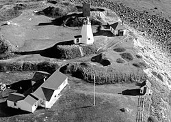
Fort Andrew is a former fort built as Gurnet Fort in 1776 for the American Revolutionary War on Gurnet Point in Plymouth, Massachusetts. It became a federal fort and was rebuilt in 1808, and again in 1863 during the Civil War when it received its current name. It is named for John A. Andrew, governor of Massachusetts 1861–1866. [1] In 1863 Fort Standish was built nearby on Saquish Head. After the war, the federal government declared Fort Andrew an inactive military reservation in 1869. The reservation was sold in 1926 and mostly became private property, except for the US Coast Guard light station. A World War II fire control tower was built on the parapet of the old fort. Plymouth (Gurnet Point) lighthouse is also on Gurnet Point, and was moved inside the fort's earthworks to protect it from beach erosion in 1997–1998. [2]

Contents

History

Gurnet Fort was built in 1776 for the American Revolutionary War, via a resolution of the Massachusetts General Court of June 3, 1776. [1] It had six guns and a 60-man garrison, almost half from nearby Duxbury. The guns were smoothbore cannon, including three 12-pounders, two 9-pounders, and one 6-pounder. The lighthouse was first built in 1768, thus preceding the fort. [3] In 1776, HMS Niger briefly engaged Gurnet Fort while searching for patriot privateers. Niger grounded but was soon refloated. One of Plymouth Light's two beacons at the time was destroyed, but there were no other casualties. [2] [4]

Gurnet Fort was rebuilt with five guns in 1808 as part of the federal second system of U.S. fortifications. As with many federal forts prior to the 1890s, it does not seem to have had an official name in this era. It appears in the secretary of war's reports on fortifications dated December 1808 and December 1811. In 1808 it is mentioned as "the old work on Gurnet head, near Plymouth, has been repaired, and platforms in front". In 1811 the entry reads: "At the Gurnet Point, the entrance of the harbor; the old fort has been repaired with stone and sods, mounting five heavy guns...". [5] One source states the fort was further rebuilt during the War of 1812 to accommodate 42-pounder guns, the largest the United States had at that time. [1]

In 1863 during the Civil War the fort was rebuilt and renamed Fort Andrew, with the rebuilding designed and supervised by Major Charles E. Blunt of the United States Army Corps of Engineers. It could accommodate four guns plus three not mounted, with a bombproof shelter and two magazines. [6] The seven guns installed during the Civil War consisted of four eight-inch (203 mm) smoothbores and three 32-pounder rifled pieces. An eighth piece at Fort Andrew was a "light field piece", possibly a 6-pounder field gun or similar. [7]

Development

Through two separate transactions, one in 1808 and another in 1870, the government acquired the 11.9 acres (48,000 m2) that constituted Fort Andrew. In 1927, the War Department transferred the property to the U.S. Department of Treasury for use as a US Coast Guard Station. [2] The use of the site prior to the government's acquisition is unknown, but it currently contains a residential area, a Coast Guard facility, and a lighthouse. [7]

Researchers (presumably in the 1990s or 2000s connected with the Formerly Used Defense Sites (FUDS) program) uncovered no information pertaining to the facilities and activities of Fort Andrew (FUDS Site No. D01MA051400) prior to the Civil War. In 1863, the military rebuilt the fort and placed seven coastal defense weapons at Fort Andrew. By 30 June 1867, the fort possessed an additional light field piece installed on a temporary firing platform, which was removed by April 1880. A records search uncovered no information pertaining to the operation of the fort after 1880. The INPR indicates that the Department of Treasury acquired the land for the US Coast Guard in 1927, ending its use by the War Department, except for a 1.7-acre (6,900 m2) tract that the War Department used for a fire control tower in World War II. Documents located by the research team did not mention the use of any CWM at this site. [7]

Present

The lighthouse remains within the fort's earthworks. The World War II fire control tower was demolished at some time postwar. The fort is only accessible to the public during seasonal open houses at the lighthouse. [2]

See also

Related Research Articles

<span class="mw-page-title-main">Fort William and Mary</span> United States historic place

Fort William and Mary was a colonial fortification in Britain's worldwide system of defenses, defended by soldiers of the Province of New Hampshire who reported directly to the royal governor. The fort, originally known as "The Castle," was situated on the island of New Castle, New Hampshire, at the mouth of the Piscataqua River estuary. It was renamed Fort William and Mary circa 1692, after the accession of the monarchs William III and Mary II to the British throne. It was captured by Patriot forces, recaptured, and later abandoned by the British in the Revolutionary War. The fort was renamed Fort Constitution in 1808 following rebuilding. The fort was further rebuilt and expanded through 1899 and served actively through World War II.

<span class="mw-page-title-main">Fort Moultrie</span> United States historic place

Fort Moultrie is a series of fortifications on Sullivan's Island, South Carolina, built to protect the city of Charleston, South Carolina. The first fort, formerly named Fort Sullivan, built of palmetto logs, inspired the flag and nickname of South Carolina, as "The Palmetto State". The fort was renamed for the U.S. patriot commander in the Battle of Sullivan's Island, General William Moultrie. During British occupation, in 1780–1782, the fort was known as Fort Arbuthnot.

<span class="mw-page-title-main">Fort McClary</span> United States historic place

Fort McClary is a former defensive fortification of the United States military located along the southern coast at Kittery Point, Maine at the mouth of the Piscataqua River. It was used throughout the 19th century to protect approaches to the harbor of Portsmouth, New Hampshire and the Portsmouth Naval Shipyard in Kittery. The property and its surviving structures are now owned and operated by the State of Maine as Fort McClary State Historic Site, including a blockhouse dating from 1844.

<span class="mw-page-title-main">House Island (Maine)</span> Private island in Maine, United States

House Island is a private island in Portland Harbor in Casco Bay, Maine, United States. It is part of the City of Portland. The island is accessible only by boat. Public access is prohibited, except for an on-request tour sanctioned by the island's owners. House Island includes three buildings on the east side and Fort Scammell on the west side. The buildings are used as vacation rentals and other summer residences. The island's name derives from the site of an early European house, believed that built by Capt. Christopher Levett, an English explorer of the region.

<span class="mw-page-title-main">Fort Preble</span>

Fort Preble was a military fort in South Portland, Maine, United States, built in 1808 and progressively added to through 1906. The fort was active during all major wars from the War of 1812 through World War II. The fort was deactivated in 1950. It is now on the campus of Southern Maine Community College.

<span class="mw-page-title-main">Seacoast defense in the United States</span> Coastal forts construction and maintenance in the U.S.

Seacoast defense was a major concern for the United States from its independence until World War II. Before airplanes, many of America's enemies could only reach it from the sea, making coastal forts an economical alternative to standing armies or a large navy. After the 1940s, it was recognized that fixed fortifications were obsolete and ineffective against aircraft and missiles. However, in prior eras foreign fleets were a realistic threat, and substantial fortifications were built at key locations, especially protecting major harbors.

<span class="mw-page-title-main">Plymouth Light</span> Lighthouse

Plymouth Light, also known as Gurnet Light, is a historic lighthouse located on Gurnet Point at the entrance to Plymouth Bay in the town of Plymouth, Massachusetts. The light is accessible only by passing through the town of Duxbury, which lies to the north. The tower is located inside the earthworks of Fort Andrew, which existed in the Civil War, War of 1812, and Revolutionary War.

<span class="mw-page-title-main">Fort Pickering</span> United States historic place

Fort Pickering is a 17th-century historic fort site on Winter Island in Salem, Massachusetts. Fort Pickering operated as a strategic coastal defense and military barracks for Salem Harbor during a variety of periods, serving as a fortification from the Anglo-Dutch Wars through World War II. Construction of the original fort began in 1643 and it saw use as a military installation into the 20th century. Fort Miller in Marblehead also defended Salem's harbor from the 1630s through the American Civil War. Fort Pickering is a First System fortification named for Colonel Timothy Pickering, born in Salem, adjutant general of the Continental Army and secretary of war in 1795. Today, the remains of the fort are open to the public as part of the Winter Island Maritime Park, operated by the City of Salem.

<span class="mw-page-title-main">Fort Sewall</span> United States historic place

Fort Sewall is a historic coastal fortification in Marblehead, Massachusetts. It is located at Gale's Head, the northeastern point of the main Marblehead peninsula, on a promontory that overlooks the entrance to Marblehead Harbor. Until 1814 it was called Gale's Head Fort.

Fort Wolcott was a fortification on the small Goat Island in Newport Harbor of Narragansett Bay less than 1 mile west of the city of Newport, Rhode Island. The attacks on HMS St John and HMS Liberty occurred near the fort.

Fort Glover was a fort in Marblehead, Massachusetts. Fortifications on the site existed during the American Revolutionary War, the War of 1812, the Civil War, and the Spanish–American War. The fort was located on what is now Riverhead Beach on Bubier Road in Marblehead, sited to guard the beach and the Marblehead Neck causeway. It was demolished in 1917.

<span class="mw-page-title-main">Fort Defiance (Massachusetts)</span>

Fort Defiance was a fort that existed from 1794 to after 1865 on Fort Point in Gloucester, Massachusetts. The location protecting the inner harbor was also called Watch House Point.

Eastern Point Fort was a fort that was garrisoned or maintained from 1863 to 1867 on Eastern Point in Gloucester, Massachusetts, built for the American Civil War. References indicate the name has also been used to refer to the much-older Stage Fort across the harbor.

The Fort at Salisbury Point was a fort in use from 1863 to 1865 in Salisbury, Massachusetts, during the American Civil War. It was also called the Fort at Salisbury Beach. It was a nine-gun earthwork located at the mouth of the Merrimack River at what is now the Salisbury Beach State Reservation, where eventual erosion washed it away. A 1903 reference states it was on the site of the Revolutionary War Fort Nichols, but that site is in doubt, and may have been at the location called Salisbury Point in Amesbury, several miles up the river. The Fort at Salisbury Point was sometimes referred to by local civilians as Fort Nichols in the Civil War era. The fort was designed and built under the supervision of Major Charles E. Blunt of the United States Army Corps of Engineers. An armament report dated June 30, 1866 lists nine heavy guns and one 12-pounder field gun. The heavy guns were three 8-inch smoothbore Rodman guns, three 42-pounder rifled guns, and three 30-pounder rifled guns. From November 1864 to June 1865 it was garrisoned by the 20th Unattached Company of Massachusetts militia. The Museum at Salisbury Point commemorates the soldiers who fought in the war.

Fort Philip was a fort built in 1776 during the American Revolutionary War and rebuilt in 1808, which also served in the War of 1812 to around 1815. It was in Newburyport, Massachusetts on the northern end of Plum Island, known as Lighthouse Point, guarding the mouth of the Merrimack River. The 1808 rebuilding was part of the second system of US fortifications. The secretary of war's report on fortifications in December 1808 states that "...a battery of wood, filled in with sand and surmounted with sod, has been erected. It... was constructed of wood on account of the shifting sands." A subsequent report in December 1811 describes the fort as "...an enclosed battery, built of earth and timber, mounting five heavy guns... ." The site eventually washed away in the 1830s. A militia artillery battery was stationed in the area in the Spanish–American War.

Fort Standish was a fort built in 1863 for the American Civil War on Saquish Head in Plymouth, Massachusetts. It was named for Myles Standish, military leader of the Plymouth Colony in the 1620s, and augmented the nearby Fort Andrew on Gurnet Point. It was designed and constructed under the supervision of Major Charles E. Blunt of the United States Army Corps of Engineers. The fort had five gun emplacements with five 8-inch smoothbore guns, along with a bombproof shelter, two magazines, and a well. Outside the fort were a barracks, officers' quarters, and a mess hall. From January to June 1865 the fort was garrisoned by the 27th Unattached Company of Massachusetts militia.

Fort Miller was a coastal defense fort in Marblehead, Massachusetts, in existence circa 1630–1900. Circa 1861 it was renamed for James Miller, a colonel in the War of 1812, distinguished for his actions in the Battle of Lundy's Lane. He was later Collector of the Port in nearby Salem from 1824 to 1849.

The Harbor Defenses of Portsmouth was a United States Army Coast Artillery Corps harbor defense command. It coordinated the coast defenses of Portsmouth, New Hampshire and the nearby Portsmouth Naval Shipyard in Kittery, Maine from 1900 to 1950, both on the Piscataqua River, beginning with the Endicott program. These included both coast artillery forts and underwater minefields. The command originated circa 1900 as the Portsmouth Artillery District, was renamed Coast Defenses of Portsmouth in 1913, and again renamed Harbor Defenses of Portsmouth in 1925.

<span class="mw-page-title-main">Harbor Defenses of New Bedford</span> Military unit

The Harbor Defenses of New Bedford was a United States Army Coast Artillery Corps harbor defense command. It coordinated the coast defenses of New Bedford, Massachusetts and the nearby Cape Cod Canal from 1900 to 1950, beginning with the Endicott program. These included a coast artillery fort and an underwater minefield. The command originated circa 1900 as the New Bedford Artillery District, was renamed Coast Defenses of New Bedford in 1913, and again renamed Harbor Defenses of New Bedford in 1925.

<span class="mw-page-title-main">Stage Fort</span>

Stage Fort was a fort that existed from 1635 to 1898 on Stage Head in what is now Stage Fort Park in Gloucester, Massachusetts.

References

  1. 1 2 3 Roberts, p. 393
  2. 1 2 3 4 "Massachusetts - Fort Andrew and Gurnet Fort". American Forts Network. Retrieved 16 June 2020.
  3. Archive link for Historic Lighthouse information at USCG.mil
  4. The Gurnet by Charles W.E. Morris at Pilgrimhall.org
  5. Wade, pp. 236, 242
  6. Manuel, pp. 49–51
  7. 1 2 3 "U.S. Army Corps of Engineers Huntsville Center project fact sheet Formerly Used Defense Sites (FUDS) - Fort Andrew". United States Army Corps of Engineers. 30 November 1995. Archived from the original on 15 November 2001. Retrieved 25 July 2020.