
Crow Agency is a census-designated place (CDP) in Big Horn County, Montana, United States and is near the actual location for the Little Bighorn National Monument and re-enactment produced by the Real Bird family known as Battle of the Little Bighorn Reenactment. The population was 1,616 at the 2010 census. It is the governmental headquarters of the Crow Native Americans. It is also the location of the "agency offices" where the federal Superintendent of the Crow Indian Reservation and his staff interacts with the Crow Tribe, pursuant to federal treaties and statutes.

Bighorn Canyon National Recreation Area is a national recreation area established by an act of Congress on October 15, 1966, following the construction of the Yellowtail Dam by the Bureau of Reclamation. It is one of over 420 sites managed by the U.S. National Park Service. The recreation area spans 120,296.22 acres, straddling the border between Wyoming and Montana. It is divided into two distinct areas, the North District accessed via Fort Smith, Montana and the South District accessed through Lovell, Wyoming. There is no thru road inside the recreation area connecting the two districts. The Yellowtail Dam is located in the North District. It is named after the famous Crow leader Robert Yellowtail, harnesses the waters of the Bighorn River by turning that variable watercourse into Bighorn Lake. The lake extends 71 miles (114 km) through Wyoming and Montana, 55 miles (89 km) of which lie within the national recreation area. The lake provides recreational boating, fishing, water skiing, kayaking, and birding opportunities to visitors. About one third of the park unit is located on the Crow Indian Reservation. Nearly one-quarter of the Pryor Mountains Wild Horse Range lies within the Bighorn Canyon National Recreation Area.

The Tongue River is a tributary of the Yellowstone River, approximately 265 mi (426 km) long, in the U.S. states of Wyoming and Montana. The Tongue rises in Wyoming in the Big Horn Mountains, flows generally northeast through northern Wyoming and southeastern Montana, and empties into the Yellowstone River at Miles City, Montana. Most of the course of the river is through the beautiful and varied landscapes of eastern Montana, including the Tongue River Canyon, the Tongue River breaks, the pine hills of southern Montana, and the buttes and grasslands that were formerly the home of vast migratory herds of American bison.

Red Cloud's War was an armed conflict between an alliance of the Lakota, Northern Cheyenne, and Northern Arapaho peoples against the United States and the Crow Nation that took place in the Wyoming and Montana territories from 1866 to 1868. The war was fought over control of the western Powder River Country in present north-central Wyoming.

The Treaty of Fort Laramie is an agreement between the United States and the Oglala, Miniconjou, and Brulé bands of Lakota people, Yanktonai Dakota, and Arapaho Nation, following the failure of the first Fort Laramie treaty, signed in 1851.

Fort Laramie was a significant 19th-century trading post, diplomatic site, and military installation located at the confluence of the Laramie and the North Platte Rivers. They joined in the upper Platte River Valley in the eastern part of the present-day U.S. state of Wyoming. The fort was founded as a private trading-post in the 1830s to service the overland fur trade; in 1849, it was purchased by the United States Army. The site was located east of the long climb leading to the best and lowest crossing-point over the Rocky Mountains at South Pass and became a popular stopping-point for migrants on the Oregon Trail. Along with Bent's Fort on the Arkansas River, the trading post and its supporting industries and businesses were the most significant economic hub of commerce in the region.

The Powder River Expedition of 1865 also known as the Powder River War or Powder River Invasion, was a large and far-flung military operation of the United States Army against the Lakota Sioux, Cheyenne, and Arapaho Indians in Montana Territory and Dakota Territory. Although soldiers destroyed one Arapaho village and established Fort Connor to protect gold miners on the Bozeman Trail, the expedition is considered a failure because it failed to defeat or intimidate the Indians.

The Bozeman Trail was an overland route in the Western United States, connecting the gold rush territory of southern Montana to the Oregon Trail in eastern Wyoming. Its most important period was from 1863 to 1868. Despite the fact that the major part of the route in Wyoming used by all Bozeman Trail travelers in 1864 was pioneered by Allen Hurlbut, it was named after John Bozeman. Many miles of the Bozeman Trail in present Montana followed the tracks of Bridger Trail, opened by Jim Bridger in 1864.

Fort Phil Kearny was an outpost of the United States Army that existed in the late 1860s in present-day northeastern Wyoming along the Bozeman Trail. Construction began in 1866 on Friday, July 13, by Companies A, C, E, and H of the 2nd Battalion, 18th Infantry, under the direction of the regimental commander and Mountain District commander Colonel Henry B. Carrington.

The Crow Indian Reservation is the homeland of the Crow Tribe. Established 1868, the reservation is located in parts of Big Horn, Yellowstone, and Treasure counties in southern Montana in the United States. The Crow Tribe has an enrolled membership of approximately 11,000, of whom 7,900 reside in the reservation. 20% speak Crow as their first language.

Fort Fetterman was constructed in 1867 by the United States Army on the Great Plains frontier in Dakota Territory, approximately 11 miles northwest of present-day Douglas, Wyoming. Located high on the bluffs south of the North Platte River, it served as a major base for the start of several United States military expeditions against warring Native American tribes. The fort is listed on the National Register of Historic Places.

Fort Reno also known as Fort Connor or Old Fort Reno, was a wooden fort established on August 15, 1865 by the United States Army in Dakota Territory in present-day Johnson County, Wyoming. The fort was built to protect travelers on the Bozeman Trail from Native American tribes.
The Fetterman Fight, also known as the Fetterman Massacre or the Battle of the Hundred-in-the-Hands or the Battle of a Hundred Slain, was a battle during Red Cloud's War on December 21, 1866, between a confederation of the Lakota, Cheyenne, and Arapaho tribes and a detachment of the United States Army, based at Fort Phil Kearny, Wyoming. The U.S. military mission was intended to protect travelers on the Bozeman Trail. A group of ten warriors, including Crazy Horse, acted to lure a detachment of U.S. soldiers into an ambush. All 81 men under the command of Captain William J. Fetterman were then killed by the Native American warriors. At the time, it was the worst military disaster ever suffered by the U.S. Army on the Great Plains.

The Bridger Trail, also known as the Bridger Road and Bridger Immigrant Road, was an overland route connecting the Oregon Trail to the gold fields of Montana. Gold was discovered in Virginia City, Montana in 1863, prompting settlers and prospectors to find a trail to travel from central Wyoming to Montana. In 1863, John Bozeman and John Jacobs scouted the Bozeman Trail, which was a direct route to the Montana gold fields through the Powder River Country. At the time the region was controlled by the Sioux, Cheyenne and Arapaho, who stepped up their raids in response to the stream of settlers along the trail.

Fort McKinney (1877–1894) was a military post located in North Eastern Wyoming, near the Powder River.
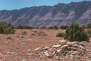
The Bad Pass Trail, also known as the Sioux Trail, was established by Native Americans on the border of present-day Montana and Wyoming as a means of access from the Bighorn Basin in Wyoming to Bison-hunting grounds in the Grapevine Creek area of Montana. Marked by stone cairns, the trail led across Bad Pass and was established in pre-Columbian times. After Europeans arrived in the area it was frequented by fur trappers and mountain men, beginning in 1824. Trappers assembled pack trains at the junction of the Shoshone River and the Bighorn River, using the Bad Pass Trail to avoid Bighorn Canyon. The trail ended at the mouth of Grapevine Creek on the Bighorn, from which the pack train could float down the Bighorn on rafts to the Yellowstone River and then to the Missouri and on to St. Louis.

The Powder River Crossing, officially known as Powder River Station-Powder River Crossing , is an abandoned settlement located on the east bank of the Powder River in southeast Johnson County about twenty-four miles east of Kaycee, Wyoming. It developed after a wooden toll bridge was built across the Powder River in 1877, at a site that was originally used as a ford. With crossing secured, a settlement developed here in the late 19th century, incorporating a stage stop on the Bozeman Trail. The site is notable for having well-preserved wagon ruts from the pioneer era.
Crazy Woman Crossing is a historic place on the Bozeman Trail, in Johnson County, Wyoming, United States, about twenty miles southeast of Buffalo. Crazy Woman Crossing was one of three major fords used by travelers across creeks and rivers in this area. It is significant as the site of the Battle of Crazy Woman, a skirmish during Red Cloud's War in 1866. The United States pulled out of this territory after negotiation with the Lakota and allies of the Treaty of Fort Laramie of 1868.
This is a timeline of pre-statehood Montana history comprising substantial events in the history of the area that would become the State of Montana prior to November 8, 1889. This area existed as Montana Territory from May 28, 1864, until November 8, 1889, when it was admitted to the Union as the State of Montana.


