Jefferson County, Montana

Last updated

Jefferson County
Jefferson County Courthouse (2013) - Jefferson County, Montana.png
Map of Montana highlighting Jefferson County.svg
Location within the U.S. state of Montana
Montana in United States.svg
Montana's location within the U.S.
Coordinates: 46°11′N112°07′W / 46.18°N 112.11°W / 46.18; -112.11
CountryFlag of the United States.svg United States
StateFlag of Montana.svg  Montana
FoundedFebruary 2, 1865 [1]
Named for Thomas Jefferson
Seat Boulder
Largest town Clancy
Area
  Total1,659 sq mi (4,300 km2)
  Land1,656 sq mi (4,290 km2)
  Water2.6 sq mi (7 km2)  0.2%
Population
 (2020)
  Total12,085
  Estimate 
(2022)
12,826 Increase2.svg
  Density7/sq mi (3/km2)
Time zone UTC−7 (Mountain)
  Summer (DST) UTC−6 (MDT)
Congressional district 2nd
Website www.jeffersoncounty-mt.gov
  • Montana county number 51

Jefferson County is a county in Montana, United States. As of the 2020 census, the population was 12,085. [2] Its county seat is Boulder. [3] The county was created in 1865 [4] and named for President Thomas Jefferson. [5]

Contents

Jefferson County is part of the Helena, MT Micropolitan Statistical Area.

Geography

According to the United States Census Bureau, the county has a total area of 1,659 square miles (4,300 km2), of which 1,656 square miles (4,290 km2) is land and 2.6 square miles (6.7 km2) (0.2%) is water. [6]

Major highways

Adjacent counties

National protected areas

Politics

United States presidential election results for Jefferson County, Montana [7]
Year Republican Democratic Third party
No.%No.%No.%
2020 5,34565.57%2,62532.20%1812.22%
2016 4,17762.21%1,99829.76%5398.03%
2012 4,05562.18%2,27234.84%1942.98%
2008 3,53855.80%2,58240.72%2213.49%
2004 3,84465.51%1,88132.06%1432.44%
2000 3,30864.07%1,51329.30%3426.62%
1996 2,24846.82%1,77536.97%77816.20%
1992 1,54136.47%1,41533.49%1,26930.04%
1988 2,00752.31%1,74645.50%842.19%
1984 2,22661.53%1,32436.59%681.88%
1980 1,84157.12%1,05532.73%32710.15%
1976 1,38752.26%1,21045.59%572.15%
1972 1,28156.06%90439.56%1004.38%
1968 79845.06%82046.30%1538.64%
1964 66240.59%96759.29%20.12%
1960 81751.38%76948.36%40.25%
1956 1,04961.38%66038.62%00.00%
1952 1,08460.76%68738.51%130.73%
1948 75045.62%83650.85%583.53%
1944 79749.72%80350.09%30.19%
1940 83039.58%1,25960.04%80.38%
1936 57327.78%1,40968.30%813.93%
1932 78437.09%1,24658.94%843.97%
1928 1,01356.97%75142.24%140.79%
1924 64836.49%43424.44%69439.08%
1920 96954.47%68838.67%1226.86%
1916 71236.63%1,12457.82%1085.56%
1912 23920.03%47940.15%47539.82%
1908 54639.22%71451.29%1329.48%
1904 66345.54%58039.84%21314.63%

Demographics

Historical population
CensusPop.Note
1870 1,531
1880 2,46460.9%
1890 6,026144.6%
1900 5,330−11.5%
1910 5,6015.1%
1920 5,203−7.1%
1930 4,133−20.6%
1940 4,66412.8%
1950 4,014−13.9%
1960 4,2977.1%
1970 5,23821.9%
1980 7,02934.2%
1990 7,93912.9%
2000 10,04926.6%
2010 11,40613.5%
2020 12,0856.0%
2022 (est.)12,826 [8] 6.1%
U.S. Decennial Census [9]
1790–1960, [10] 1900–1990, [11]
1990–2000, [12] 2010–2020 [2]

2020 census

As of the 2020 census, there were 12,085 people living in the county. [13]

2010 census

As of the 2010 census, there were 11,406 people, 4,512 households, and 3,301 families residing in the county. The population density was 6.9 inhabitants per square mile (2.7/km2). There were 5,055 housing units at an average density of 3.1 per square mile (1.2/km2). The racial makeup of the county was 95.5% white, 1.4% American Indian, 0.4% Asian, 0.1% black or African American, 0.4% from other races, and 2.2% from two or more races. Those of Hispanic or Latino origin made up 2.0% of the population. In terms of ancestry, 31.3% were German, 19.1% were Irish, 17.2% were English, 10.8% were Norwegian, and 4.2% were American.

Of the 4,512 households, 28.8% had children under the age of 18 living with them, 63.7% were married couples living together, 5.4% had a female householder with no husband present, 26.8% were non-families, and 22.6% of all households were made up of individuals. The average household size was 2.48 and the average family size was 2.90. The median age was 46.2 years.

The median income for a household in the county was $56,695 and the median income for a family was $67,195. Males had a median income of $50,978 versus $34,148 for females. The per capita income for the county was $26,437. About 2.7% of families and 12.8% of the population were below the poverty line, including 5.1% of those under age 18 and 8.6% of those age 65 or over.

Communities

Towns

Census-designated places

Unincorporated communities

Former communities

See also

Related Research Articles

<span class="mw-page-title-main">Wheatland County, Montana</span> County in Montana, United States

Wheatland County is a county in the U.S. state of Montana. As of the 2020 census, the population was 2,069. Its county seat is Harlowton. Wheatland County was established on February 22, 1917, with areas partitioned from Meagher and Sweet Grass counties. It was named for the abundant wheat-growing areas across the center portion of the new county's area.

<span class="mw-page-title-main">Valley County, Montana</span> County in Montana, United States

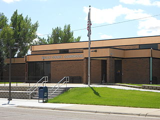
Valley County is a county in the U.S. state of Montana. Valley County was created in 1893 with area partitioned from Dawson County. As of the 2020 census, the population was 7,578. Its county seat is Glasgow. It is located on the Canada–United States border with Saskatchewan.

<span class="mw-page-title-main">Toole County, Montana</span> County in Montana, United States

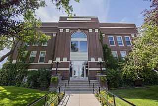
Toole County is a county in the northern portion of the U.S. state of Montana. As of the 2020 census, the population was 4,971. Its county seat is Shelby. The county was established in 1914 from parts of Hill County and Teton County and was named after Joseph Toole, the first and fourth governor of Montana. Its northern boundary is the Canada–United States border south of Alberta.

<span class="mw-page-title-main">Silver Bow County, Montana</span> County in Montana, United States

Silver Bow County is a county in the U.S. state of Montana. As of the 2020 census, the population was 35,133. Its county seat is Butte. In 1977, the city and county governments consolidated to form the single entity of Butte-Silver Bow. Additionally, the town of Walkerville is a separate municipality from Butte and is within the county.

<span class="mw-page-title-main">Roosevelt County, Montana</span> County in Montana, United States

Roosevelt County is a county in the U.S. state of Montana. As of the 2020 census, the population was 10,794. Its county seat is Wolf Point. Roosevelt County was created by the Montana Legislature in 1919 from a portion of Sheridan County. The name honors former president Theodore Roosevelt, who had died earlier that year.

<span class="mw-page-title-main">Richland County, Montana</span> County in Montana, United States

Richland County is a county in the U.S. state of Montana. As of the 2020 census, the population was 11,491. Its county seat is Sidney.

<span class="mw-page-title-main">Powell County, Montana</span> County in Montana, United States

Powell County is a county in the U.S. state of Montana. As of the 2020 census, the population was 6,946. Its county seat is Deer Lodge.

<span class="mw-page-title-main">Park County, Montana</span> County in Montana, United States

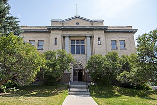
Park County is a county in the U.S. state of Montana. At the 2020 census, the population was 17,191. Its county seat is Livingston. A small part of Yellowstone National Park is in the southern part of the county.

<span class="mw-page-title-main">Mineral County, Montana</span> County in Montana, United States

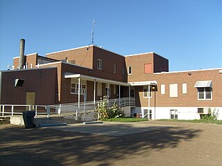
Mineral County is a county located in the U.S. state of Montana. As of the 2020 census, the population was 4,535. Its county seat is Superior.

<span class="mw-page-title-main">Meagher County, Montana</span> County in Montana, United States

Meagher County is a county located in the U.S. state of Montana. As of the 2020 census, the population was 1,927. Its county seat is White Sulphur Springs.

<span class="mw-page-title-main">Madison County, Montana</span> County in Montana, United States

Madison County is a county in the U.S. state of Montana. As of the 2020 census, the population was 8,623. Its county seat is Virginia City. The county was founded in 1865; at the time it was part of the Montana Territory.

<span class="mw-page-title-main">Lewis and Clark County, Montana</span> County in Montana, United States

Lewis and Clark County is a county located in the U.S. state of Montana. As of the 2020 census, the population was 70,973. Its county seat is Helena, the state capital. The numerical designation for Lewis and Clark County is 5. The county was established on June 2, 1865, as one of the nine original counties of the Territory of Montana named Edgerton County in honor of Sidney Edgerton, first Governor of the Territory of Montana, and was renamed Lewis and Clark County on March 1, 1868, in honor of explorers Meriwether Lewis and William Clark.

<span class="mw-page-title-main">Judith Basin County, Montana</span> County in Montana, United States

Judith Basin County is a county in the U.S. state of Montana. As of the 2020 census, the population was 2,023. Its county seat is the town of Stanford.

<span class="mw-page-title-main">Granite County, Montana</span> County in Montana, United States

Granite County is a county located in the U.S. state of Montana. As of the 2020 census, the population was 3,309. Its county seat is Philipsburg. The county was founded in 1893, and was named for a mountain which contains the Granite Mountain silver mine.

<span class="mw-page-title-main">Garfield County, Montana</span> County in Montana, United States

Garfield County is a county located in the U.S. state of Montana. As of the 2020 census, the population was 1,173. Its county seat is Jordan.

<span class="mw-page-title-main">Fergus County, Montana</span> County in Montana, United States

Fergus County is a county in the U.S. state of Montana. As of the 2020 census, the population was 11,446. Its county seat is Lewistown. The county was founded in 1885 and named for James Fergus, a Montana politician who was instrumental in creating the county.

<span class="mw-page-title-main">Fallon County, Montana</span> County in Montana, United States

Fallon County is a county located in the U.S. state of Montana. As of the 2020 census, the population was 3,049. Its county seat is Baker. The county was created in 1913 from a portion of Custer County. It is named for Benjamin O'Fallon, a nephew of Captain William Clark and an Indian agent for the upper Missouri region from 1823 to 1827.

<span class="mw-page-title-main">Daniels County, Montana</span> County in Montana, United States

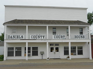
Daniels County is a county located in the U.S. state of Montana. As of the 2020 census, the population was 1,661. Its county seat is Scobey. It is on Montana's north border, and thus abuts the Canada–US border with Saskatchewan.

<span class="mw-page-title-main">Chouteau County, Montana</span> County in Montana, United States

Chouteau County is a county located in the North-Central region of the U.S. state of Montana. As of the 2020 census, the population was 5,895. Its county seat is Fort Benton. The county was established in 1865 as one of the original nine counties of Montana, and named in 1882 after Pierre Chouteau Jr., a fur trader who established a trading post that became Fort Benton, which was once an important port on the Missouri River.

<span class="mw-page-title-main">Broadwater County, Montana</span> County in Montana, United States

Broadwater County is a county in the U.S. state of Montana. As of the 2020 census, the population was 6,774. Its county seat is Townsend. The county was named for Charles Arthur Broadwater, a noted Montana railroad, real estate, and banking magnate.

References

  1. "Montana County Formation Table". genealogytrails.com. Retrieved April 3, 2018.
  2. 1 2 "State & County QuickFacts". United States Census Bureau. Retrieved May 8, 2023.
  3. "Find a County". National Association of Counties. Archived from the original on May 31, 2011. Retrieved June 7, 2011.
  4. "Montana Place Names Companion". Montana Place Names From Alzada to Zortman. Montana Historical Society Research Center. Retrieved December 1, 2014.
  5. Gannett, Henry (1905). The Origin of Certain Place Names in the United States. Govt. Print. Off. p.  168.
  6. "2010 Census Gazetteer Files". United States Census Bureau. August 22, 2012. Archived from the original on December 5, 2014. Retrieved November 28, 2014.
  7. Leip, David. "Atlas of US Presidential Elections". uselectionatlas.org. Retrieved April 3, 2018.
  8. "Annual Estimates of the Resident Population for Counties: April 1, 2020 to July 1, 2022". United States Census Bureau. Retrieved May 8, 2023.
  9. "U.S. Decennial Census". United States Census Bureau. Retrieved November 28, 2014.
  10. "Historical Census Browser". University of Virginia Library. Retrieved November 28, 2014.
  11. "Population of Counties by Decennial Census: 1900 to 1990". United States Census Bureau. Retrieved November 28, 2014.
  12. "Census 2000 PHC-T-4. Ranking Tables for Counties: 1990 and 2000" (PDF). United States Census Bureau. Archived (PDF) from the original on March 27, 2010. Retrieved November 28, 2014.
  13. "Jefferson County, Montana". United States Census Bureau. Retrieved February 29, 2024.
  14. Amazon, Jefferson County MT Google Maps (accessed January 2, 2019)
  15. Bernice, Jefferson County MT Google Maps (accessed January 2, 2019)
  16. Elk Park, Jefferson County MT Google Maps (accessed January 2, 2019)
  17. Homestake, Jefferson County MT Google Maps (accessed January 2, 2019)
  18. Leadville, Jefferson County MT Google Maps (accessed January 2, 2019)
  19. La Hood Park, Jefferson County MT Google Maps (accessed January 2, 2019)
  20. Louisville, Jefferson County MT Google Maps (accessed January 2, 2019)
  21. Pappas Place, Jefferson County MT Google Maps (accessed January 2, 2019)
  22. Paul Place, Jefferson County MT Google Maps (accessed January 2, 2019)
  23. Piedmont, Jefferson County MT Google Maps (accessed January 2, 2019)
  24. Pipestone, Jefferson County MT Google Maps (accessed January 2, 2019)
  25. Renova, Jefferson County MT Google Maps (accessed January 2, 2019)