Jefferson City, Montana

Last updated
Jefferson City, Montana
Jefferson County Montana Incorporated and Unincorporated areas Jefferson City Highlighted.svg
Location of Jefferson City, Montana
Coordinates: 46°23′12″N112°2′28″W / 46.38667°N 112.04111°W / 46.38667; -112.04111 Coordinates: 46°23′12″N112°2′28″W / 46.38667°N 112.04111°W / 46.38667; -112.04111
Country United States
State Montana
County Jefferson
Area
[1]
  Total23.22 sq mi (60.13 km2)
  Land23.22 sq mi (60.13 km2)
  Water0.00 sq mi (0.00 km2)
Elevation
[2]
4,564 ft (1,391 m)
Population
 (2020)
  Total597
  Density25.71/sq mi (9.93/km2)
Time zone UTC-7 (Mountain (MST))
  Summer (DST) UTC-6 (MDT)
ZIP code
59638
Area code 406
FIPS code 30-39400
GNIS feature ID0785437 [2]

Jefferson City is an unincorporated community and census-designated place (CDP) in Jefferson County, Montana, United States. The population was 472 at the 2010 census. [3] It is part of the Helena Micropolitan Statistical Area.

Contents

The community began as a stop along the Fort Benton and Virginia City stage line. It took its name when Jefferson County was named one of Montana Territory’s original counties on February 2, 1865. [4]

Summer activities include the Tizer Botanic Gardens & Arboretum with its 100 varieties of roses and 150 varieties of clematis. [5]

Geography

Jefferson City is located in northern Jefferson County at 46°23′12″N112°02′28″W / 46.386685°N 112.041154°W / 46.386685; -112.041154 (46.386685, -112.041154), [6] in the valley of Prickly Pear Creek. It is bordered to the north by Clancy. Interstate 15 passes through the community, with access from Exit 176. I-15 leads north 18 miles (29 km) to Helena and south 12 miles (19 km) to Boulder, the Jefferson county seat.

According to the United States Census Bureau, the Jefferson City CDP has a total area of 23.2 square miles (60.1 km2), all land. [3]

Demographics

Historical population
CensusPop.
2020 597
U.S. Decennial Census [7]

As of the census [8] of 2000, there were 295 people, 110 households, and 85 families residing in the CDP. The population density was 24.5 people per square mile (9.4/km2). There were 115 housing units at an average density of 9.5 per square mile (3.7/km2). The racial makeup of the CDP was 95.59% White, 2.03% Native American, 1.36% Asian, 0.34% from other races, and 0.68% from two or more races. Hispanic or Latino of any race were 0.34% of the population.

There were 110 households, out of which 33.6% had children under the age of 18 living with them, 69.1% were married couples living together, 4.5% had a female householder with no husband present, and 22.7% were non-families. 20.0% of all households were made up of individuals, and 4.5% had someone living alone who was 65 years of age or older. The average household size was 2.68 and the average family size was 3.11.

In the CDP, the population was spread out, with 25.4% under the age of 18, 5.8% from 18 to 24, 30.8% from 25 to 44, 27.5% from 45 to 64, and 10.5% who were 65 years of age or older. The median age was 40 years. For every 100 females, there were 99.3 males. For every 100 females age 18 and over, there were 105.6 males.

The median income for a household in the CDP was $53,125, and the median income for a family was $52,917. Males had a median income of $28,125 versus $32,500 for females. The per capita income for the CDP was $21,953. None of the families and 1.4% of the population were living below the poverty line.

Education

Jefferson High School in Boulder serves the Jefferson City students. [9]

Notable person

Related Research Articles

<span class="mw-page-title-main">Jefferson County, Montana</span> County in Montana, United States

Jefferson County is a county in Montana, United States. As of the 2020 census, the population was 12,085. Its county seat is Boulder. The county was created in 1865 and named for President Thomas Jefferson.

<span class="mw-page-title-main">Gilpin County, Colorado</span> County in Colorado, United States

Gilpin County is a county located in the U.S. state of Colorado, smallest in land area behind only the City and County of Broomfield. As of the 2020 census, the population was 5,808. The county seat is Central City. The county was formed in 1861, while Colorado was still a Territory, and was named after Colonel William Gilpin, the first territorial governor.

Kaibab is an unincorporated community and census-designated place (CDP) in Mohave County, Arizona, United States. It is within the Kaibab Indian Reservation. The population of the CDP was 140 at the 2020 census.

<span class="mw-page-title-main">Radersburg, Montana</span> Census-designated place in Montana, United States

Radersburg is a census-designated place (CDP) in Broadwater County, Montana, United States. The population was 66 at the 2010 census.

<span class="mw-page-title-main">Martin City, Montana</span> Unincorporated community in Montana, United States

Martin City is an unincorporated community and census-designated place (CDP) in Flathead County, Montana, United States. As of the 2010 census, it had a population of 500, up from 331 in 2000.

<span class="mw-page-title-main">Montana City, Montana</span> Census-designated place in Montana, United States

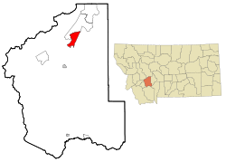
Montana City is an unincorporated community and census-designated place (CDP) in Jefferson County, Montana, United States. The population was 2,715 at the 2010 census, up from 2,094 in 2000. It is part of the Helena Micropolitan Statistical Area.

<span class="mw-page-title-main">Kicking Horse, Montana</span> Census-designated place in Montana, United States

Kicking Horse is a census-designated place (CDP) in Lake County, Montana, United States. The population was 286 at the 2010 census, up from 80 in 2000.

<span class="mw-page-title-main">Augusta, Montana</span> Census-designated place in Montana, United States

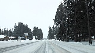
Augusta is an unincorporated community and census-designated place (CDP) in Lewis and Clark County, Montana, United States. The population was 309 at the 2010 census and rising to 316 in the 2020 census. The most accepted version in the naming of this town is after Augusta Hogan, thought to be the first child born in this town, the daughter of J. D. Hogan, an early rancher.

<span class="mw-page-title-main">Helena Valley Northeast, Montana</span> Census-designated place in Montana, United States

Helena Valley Northeast is a census-designated place (CDP) in Lewis and Clark County, Montana, United States. The population was 2,995 at the 2010 census. It is part of the Helena Micropolitan Statistical Area.

<span class="mw-page-title-main">Helena Valley Northwest, Montana</span> CDP in Montana, United States

Helena Valley Northwest is a census-designated place (CDP) in Lewis and Clark County, Montana, United States. The population was 3,482 at the 2010 census. It is part of the Helena Micropolitan Statistical Area.

<span class="mw-page-title-main">Helena Valley Southeast, Montana</span> Census-designated place in Montana, United States

Helena Valley Southeast is a census-designated place (CDP) in Lewis and Clark County, Montana, United States. The population was 8,227 at the 2010 census. It is part of the Helena Micropolitan Statistical Area.

<span class="mw-page-title-main">Helena Valley West Central, Montana</span> Census-designated place in Montana, United States

Helena Valley West Central is a census-designated place (CDP) in Lewis and Clark County, Montana, United States. The population was 7,883 at the 2010 census. It is part of the Helena Micropolitan Statistical Area.

<span class="mw-page-title-main">Lincoln, Montana</span> Census-designated place in Montana, United States

Lincoln is an unincorporated community and census-designated place (CDP) in Lewis and Clark County, Montana, United States. As of the 2010 census, the population was 1,013.

<span class="mw-page-title-main">Seeley Lake, Montana</span> CDP in Montana, United States

Seeley Lake is a census-designated place (CDP) in Missoula County, Montana, United States. It is part of the 'Missoula, Montana Metropolitan Statistical Area'. The town sits beside the 1,031.5 acres lake Seeley Lake. The population was 1,659 at the 2010 census, an increase from its population of 1,436 in 2000.

<span class="mw-page-title-main">Avon, Montana</span> CDP in Montana, United States

Avon is a census-designated place (CDP) in Powell County, Montana, United States. The population was 124 at the 2000 census. The town sits along the Little Blackfoot River, and serves as a gateway to the Beaverhead-Deerlodge National Forest.

<span class="mw-page-title-main">Elliston, Montana</span> CDP in Montana, United States

Elliston is a census-designated place (CDP) in Powell County, Montana, United States. The population was 225 at the 2000 census.

<span class="mw-page-title-main">Garrison, Montana</span> CDP in Montana, United States

Garrison is a census-designated place (CDP) in Powell County, Montana, United States. The population was 112 at the 2000 census.

<span class="mw-page-title-main">Cardwell, Montana</span> Census-designated place in Montana, United States

Cardwell is a census-designated place (CDP) in Jefferson County, Montana, United States. The population was 50 at the 2010 census. It is part of the Helena Micropolitan Statistical Area.

<span class="mw-page-title-main">Clancy, Montana</span> Census-designated place in Montana, United States

Clancy is an unincorporated community and census-designated place (CDP) in Jefferson County, Montana, United States. The population was 1,661 at the 2010 census, up from 1,406 in 2000. It is part of the Helena Micropolitan Statistical Area.

<span class="mw-page-title-main">Helena West Side, Montana</span> Census-designated place in Montana, United States

Helena West Side is a census-designated place (CDP) in Lewis and Clark County, Montana, United States. The population was 1,637 at the 2010 census, down from 1,711 at the 2000 census due to annexation of part of the CDP by the city of Helena. It is part of the Helena Micropolitan Statistical Area.

References

  1. "ArcGIS REST Services Directory". United States Census Bureau. Retrieved September 5, 2022.
  2. 1 2 U.S. Geological Survey Geographic Names Information System: Jefferson City, Montana
  3. 1 2 "Geographic Identifiers: 2010 Census Summary File 1 (G001): Jefferson City CDP, Montana". American Factfinder. U.S. Census Bureau. Archived from the original on February 13, 2020. Retrieved August 22, 2018.
  4. "Jefferson City". Montana Place Names Companion. Montana Historical Society. Retrieved 5 April 2021.
  5. "Welcome To Our Gardens". Tizer Botanic Gardens & Arboretum. Retrieved 5 April 2021.
  6. "US Gazetteer files: 2010, 2000, and 1990". United States Census Bureau. 2011-02-12. Retrieved 2011-04-23.
  7. "Census of Population and Housing". Census.gov. Retrieved June 4, 2016.
  8. "U.S. Census website". United States Census Bureau . Retrieved 2008-01-31.
  9. "About the School". Jefferson High School. Retrieved 17 April 2021.