Fort Dundas

Last updated

Location of Fort Dundas on Melville Island. Melville and Croker Is.png
Location of Fort Dundas on Melville Island.

Fort Dundas was a short-lived British settlement on Melville Island between 1824 and 1828 in what is now the Northern Territory of Australia. It was the first of four British settlement attempts in northern Australia before Goyder's survey and establishment of Palmerston, now known as Darwin. The three later attempts were at Fort Wellington, Port Essington and Escape Cliffs.

Contents

Establishment

Sketch of Fort Dundas, 1824.jpg
Sketch of Fort Dundas by John Septimus Roe, 1 November 1824

Captain J. J. Gordon Bremer set sail on HMS Tamar from Port Jackson on the 24 August 1824 to colonise the northern part of Australia. His ship was accompanied by HMS Lady Nelson, and Countess of Harcourt. The ships transported Captain Maurie Barlow, Lieutenant John Septimus Roe, Lieutenant Everard and 23 men of the 3rd Regiment, a subaltern and 26 men of the Royal Marine, a surgeon, three commissariat workers, three free men seeking adventure and 44 convicts. [1]

The construction of a settlement began upon arrival on 27 September 1824. [2] It was officially proclaimed on 21 October 1824, on Trafalgar Day. It was named Fort Dundas and was named after Robert Dundas, the First Lord of the Admiralty.

The intention was to commence and develop trade with the Malays. During the first two years, the settlers never saw a Malay. Furthermore, the settlers had not been able to penetrate more than 32 kilometres (20 mi) into the island's interior "due to the hostility of the natives being in the most savage state of barbarism, and all attempts to conciliate them proving abortive"; such was the report to the British people. [3] The establishment of the settlement caused the border of New South Wales to be moved west from the 135th meridian to the Western Australian border (129th meridian). [1]

Captain Bremer was relieved by a Scot, Major John Campbell in 1827. Campbell's party was the first to include women. The first European marriage in the Northern Territory occurred shortly after at the fort. In his party was the wife of Lieutenant Hicks, who died shortly after. [1]

Tiwi resistance

The Tiwi put up strong resistance to the new settlers on their land.

There was no contact between the colonisers and the indigenous people of the Tiwi Islands, the Tiwi people, during the first few weeks of the settlement. Bremer noted that the first recorded meetings occurred on 25 October 1824. Exploring a small river on Bathurst Island across the strait from the settlement, Bremer came into contact with a party of ten Tiwi men. Bremer described them as initially defensive and aggressive, calming down upon the presentation of gifts:

After some time they gained confidence and came so near as to take a handkerchief and other trifles we put towards them on an oar... having given them all the boat afforded I left them apparently well satisfied. [1]

On the same day two convicts were seized but not injured. The Tiwi retreated when troops appeared on the scene, taking the convicts’ axes with them. Bremer suspected the Islanders had been watching the settlements for some time and saw the valuable metal and tools. [4]

Attacks on the fort became regular, "sometimes daily". Two people were speared to death including the fort's surgeon, Dr Gold. He was discovered with 31 spear wounds. Seven spear heads remained in his body. One had passed through his head "from ear to ear". The storekeeper John Green had 17 spear wounds and his skull was smashed open. [1]

Abandonment

Bad relations with the Tiwi people, tropical storms, isolation and low food and medical supplies caused Campbell to request that the post be closed and the garrison taken away from "this vile island". He was relieved by Captain Humphrey Hartley, but orders were received shortly after to abandon the fort in late 1828. The last of the settlers left by April 1829. One soldier could not be found and was left behind, with his wife and family sailing without him. [5]

South Australian governor Lord Kintore later declared Bremer's selection of Fort Dundas as ill-suited and "never satisfactorily explained". [1]

Excavations and recent history

3rd Regiment Shako Plate from Fort Dundas 3rd Regiment Shako Plate from Fort Dundas.jpg
3rd Regiment Shako Plate from Fort Dundas

Remnants of the fort were visible in 1895, nearly 70 years after the fort's closure. The moat and stonework from a building, thought to be a church, were present as were grave sites. [6] There were several visitors to the site in the early 1900s, who observed the remains of earthworks, part of a stone wharf, a building, and retaining walls, and noted that the once-cleared hillside had regenerated. [7] [8]

A commemoration event was held in Darwin in 1924, a century after the abandonment of the fort. [9] [10] In 1938 relics of uniforms worn at Fort Dundas were found during a medical survey of Melville Island. They were donated to the Mitchell Library at the University of Sydney in 1972. [11] In 1939, original stones were retrieved from Fort Dundas [12] [13] and used to construct a memorial to the early settlement at Darwin's garrison which was unveiled in 1945. [14] Also in 1939, mobile patrol units were established at the fort aimed at preventing trespassing on Aboriginal reserves. [15]

A 49-day excavation was completed in 1975, which mapped and documented the condition of site. Artefacts were found including a glass bottle and a 3rd Regiment brass badge or 'Shako Plate' which are now held at the Museum and Art Gallery of the Northern Territory in Fannie Bay in Darwin. The final report recommended an ongoing research program of the site. [16]

See also

Related Research Articles

<span class="mw-page-title-main">Melville Island (Northern Territory)</span> Island in Northern Territory

Melville Island is an island in the eastern Timor Sea, off the coast of the Northern Territory, Australia. Along with Bathurst Island and nine smaller uninhabited islands, it forms part of the group known as the Tiwi Islands, which are under the jurisdiction of the Northern Territory in association with the Tiwi Land Council as the regional authority.

<span class="mw-page-title-main">Cobourg Peninsula</span>

The Cobourg Peninsula is located 350 kilometres (217 mi) east of Darwin in the Northern Territory, Australia. It is deeply indented with coves and bays, covers a land area of about 2,100 square kilometres (811 sq mi), and is virtually uninhabited with a population ranging from about 20 to 30 in five family outstations, but without any notable settlement or village. It is separated from Croker Island in the east by Bowen Strait, which is 2.5 kilometres wide in the south and up to 7 kilometres in the north, and 8.5 kilometres long. In the west, it is separated from Melville Island by Dundas Strait. From Cape Don, the western point of the peninsula, to Soldier Point in the east of Melville Island, the distance is 28 kilometres (17 mi). In the north is the Arafura Sea, and in the south the Van Diemen Gulf. The highest elevation is Mount Roe in the south with an altitude of 160 metres (525 ft).

<span class="mw-page-title-main">Tiwi Islands</span> Island group of the Northern Territory, Australia

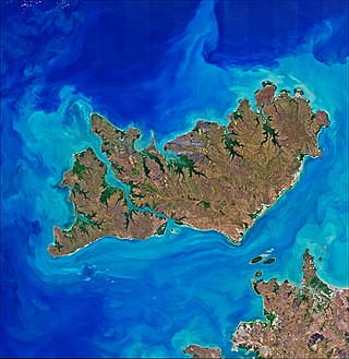
The Tiwi Islands are part of the Northern Territory, Australia, 80 km (50 mi) to the north of Darwin adjoining the Timor Sea. They comprise Melville Island, Bathurst Island, and nine smaller uninhabited islands, with a combined area of 8,320 square kilometres (3,212 sq mi).

<span class="mw-page-title-main">Port Essington</span> Location and former settlement in Northern Territory, Australia

Port Essington is an inlet and historic site located on the Cobourg Peninsula in the Garig Gunak Barlu National Park in Australia's Northern Territory. It was the site of an early attempt at British settlement, but now exists only as a remote series of ruins.

<span class="mw-page-title-main">Gordon Bremer</span> British naval officer (1786–1850)

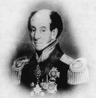
Sir James John Gordon Bremer was a British Royal Navy officer. He served in the Napoleonic Wars against France, the First Anglo-Burmese War in Burma, and the First Opium War in China.

The history of the Northern Territory began over 60,000 years ago when Indigenous Australians settled the region. Makassan traders began trading with the indigenous people of the Northern Territory for trepang from at least the 18th century onwards.

<span class="mw-page-title-main">Tiwi Islands Football League</span>

The Tiwi Islands Football League is an Australian rules football competition in the Tiwi Islands, Northern Territory, Australia.

<span class="mw-page-title-main">Australian rules football in the Northern Territory</span>

Australian Football in the Northern Territory is the most popular sport, particularly with indigenous Australian communities in Darwin, Alice Springs and the Tiwi Islands. It is governed by AFL Northern Territory.

The following lists events that happened during 1824 in Australia.

<span class="mw-page-title-main">Tiwi people</span> Australian aboriginal ethnic group

The Tiwi people are one of the many Aboriginal groups of Australia. Nearly 2,000 Tiwi people live on Bathurst and Melville Islands, which make up the Tiwi Islands, lying about 48 kilometres (30 mi) from Darwin. The Tiwi language is a language isolate, with no apparent link to the languages of Arnhem Land on the Australian mainland. Their society is based on matrilineal descent, and marriage plays a very important part in many aspects of their lives. Art and music form an intrinsic part of their societal and spiritual rituals as the Tiwi people tend to follow a certain form of indigenous Animist belief system. The Stolen Generations saw many Indigenous people brought to the Tiwi Islands who were not of direct Tiwi descent.

Bremer Island, or Dhambaliya in the local language is an island in the Arafura Sea, in the northwest of the Gulf of Carpentaria, 3.4 km off the northeast corner of Arnhem Land, Northern Territory, Australia.

The Tiwi Land Council is a land council in the Northern Territory of Australia established in 1978 to represent Aboriginal Australians living on the Tiwi Islands.

<span class="mw-page-title-main">Fort Wellington, Australia</span>

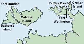
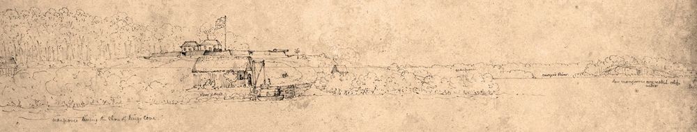
Fort Wellington was the name of a short-lived British settlement established in 1827 at Raffles Bay, on the northern side of the Cobourg Peninsula of what is now the Northern Territory of Australia, which was abandoned in 1829. It was the second of a series of four such abortive settlement attempts in Australia's Top End, the first being Fort Dundas (1824–1828) on Melville Island, the third Fort Victoria or Victoria Settlement, at Port Essington (1838–1849) on the Cobourg Peninsula, and the fourth at Escape Cliffs (1864–1867) near the mouth of the Adelaide River.

<span class="mw-page-title-main">Escape Cliffs</span> Historic settlement site in the Northern Territory, Australia

Escape Cliffs is a place on the northern coast of the Northern Territory of Australia, on the western coast of the Cape Hotham peninsula, and the eastern shore of Adam Bay, near the mouth and estuary of the Adelaide River. It lies about 60 km north-east of Darwin and is located in the Cape Hotham sector of the Djukbinj National Park. It was named by John Lort Stokes of HMS Beagle after visiting the spot in 1840, and refers to an incident where he and Lieut. Helpman escaped with their lives after being attacked by hostile Aboriginal men.

<span class="mw-page-title-main">Fly Tiwi</span> Australian airline

Fly Tiwi is an Australian airline based in Darwin, Northern Territory, offering scheduled passenger services between the Northern Territory capital and communities located on the Tiwi, South Goulburn and Croker islands, as well as a number of remote Arnhem Land communities. The company is wholly owned by the Hardy Aviation group, Australia's largest general aviation company, and was founded in 2008 in association with the Tiwi Land Council and, As of 2012 operates over 60 flights per week between 10 destinations.

<span class="mw-page-title-main">Pirlangimpi</span> Town in the Northern Territory, Australia

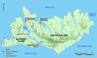
Pirlangimpi, formerly Garden Point, is a populated place on Melville Island in the Northern Territory, Australia.

The Iwaidja are an Indigenous Australian people of the Northern Territory.

Vernon Islands is a locality in the Northern Territory of Australia located over land and water in the Clarence Strait including the Vernon Islands and which is located about 55 kilometres (34 mi) north-east of the territory capital of Darwin.

Maria Josette Orsto was an aboriginal artist born at Pirlangimpi, on Melville Island. Her father, Declan Apuatimi, and her mother, Jean Baptiste Apuatimi, were also noted aboriginal artists from the Tiwi Islands. Orsto was one of the first female members of Tiwi Designs. Prior to her death she worked and lived at Wurrumiyanga on Bathurst Island.

<span class="mw-page-title-main">Robert Joel Cooper</span> Australian buffalo hunter

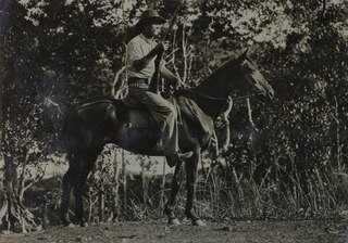
Robert Joel (Joe) Cooper was a buffalo hunter in the Northern Territory who spent much of his life on Melville Island (Yermalner).

References

  1. 1 2 3 4 5 6 Lockwood, Douglas (1968). The Front Door: Darwin 1869-1969. Adelaide: Rigby Limited. ISBN   978-0727020253.
  2. "THE NEWLY FORMED BRITISH SETTLEMENT ON THE NORTH WEST COAST OF AUSTRALIA". The Australian . No. 22. New South Wales, Australia. 10 March 1825. p. 3. Retrieved 8 January 2017 via National Library of Australia.
  3. "Melville Island". The Asiatic Journal and Monthly Register for British and Foreign India, China, and Australasia. 24. Parbury, Allen, & Co. 1827. Retrieved 9 January 2017.
  4. Morris, John. "The Tiwi and the British: an ill-fated outpost" (PDF). Aboriginal History. 25. ISSN   0314-8769 . Retrieved 8 January 2017.
  5. "Fort Dundas - Melville Island NT". Past Masters. Past Masters. Archived from the original on 21 March 2017. Retrieved 8 January 2017.
  6. "Fort Dundas—Melville Island". Northern Territory Times and Gazette . Vol. XX, no. 1133. Northern Territory, Australia. 19 July 1895. p. 3. Retrieved 8 January 2017 via National Library of Australia.
  7. "IN NORTHERN SEAS". The Observer (Adelaide) . Vol. LXII, no. 3, 305. South Australia. 4 February 1905. p. 4. Retrieved 8 January 2017 via National Library of Australia.
  8. "FORT DUNDAS, NORTHERN TERRITORY". The Observer (Adelaide) . Vol. LXIII, no. 3, 387. South Australia. 1 September 1906. p. 48. Retrieved 8 January 2017 via National Library of Australia.
  9. "Centenary Celebrations". Northern Territory Times and Gazette . Northern Territory, Australia. 23 September 1924. p. 2. Retrieved 8 January 2017 via National Library of Australia.
  10. "1824—1924: DARWIN (N.T.) CENTENARY CELEBRATION, WITH SOME SIDELIGHTS ON A "WHITE" AUSTRALIA". Western Mail . Vol. XXXIX, no. 2, 024. Western Australia. 13 November 1924. p. 19. Retrieved 8 January 2017 via National Library of Australia.
  11. "Uniform relics of the 57th Regiment from the site of Fort Dundas, Melville Island, September 1826-1829". State Library of New South Wales. New South Wales Government. Retrieved 7 January 2017.
  12. "MEMORIAL TO EARLY SETTLEMENTS". Northern Standard . No. 102. Northern Territory, Australia. 30 December 1938. p. 14. Retrieved 8 January 2017 via National Library of Australia.
  13. "PIONEER SOLDIERS MEMORIAL". Northern Standard . No. 4. Northern Territory, Australia. 13 January 1939. p. 16. Retrieved 8 January 2017 via National Library of Australia.
  14. "PORT ESSINGTON MEMORIAL CAIRN UNVEILED BY GOC AT LARRAKEYAH". Army News . Vol. 5, no. 1351. Northern Territory, Australia. 5 November 1945. p. 4. Retrieved 8 January 2017 via National Library of Australia.
  15. "MOBILE PATROL UNITS". Northern Standard . No. 25. Northern Territory, Australia. 28 March 1939. p. 8. Retrieved 8 January 2017 via National Library of Australia.
  16. Crosby, Elenor (1975). "Survey and Excavation at Fort Dundas, Melville Island, Northern Territory, 1975". The Australian Society for Historical Archaeology. doi:10.4227/11/504586DEB599D.

11°24′18″S130°25′02″E / 11.40500°S 130.41722°E / -11.40500; 130.41722