
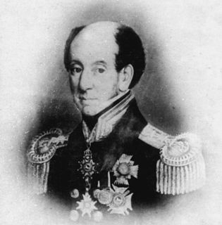
Admiral Sir James Stirling was a Scottish naval officer and colonial administrator. His enthusiasm and persistence persuaded the British Government to establish the Swan River Colony and he became the first Governor and Commander-in-Chief of Western Australia. In 1854, when Commander-in-Chief, East Indies and China Station, Stirling on his own initiative signed Britain's first Anglo-Japanese Friendship Treaty. Throughout his career Stirling showed considerable diplomatic skill and was selected for a number of sensitive missions. Paradoxically, this was not reflected in his personal dealings with officialdom and his hopes for preferment received many rebuffs. Stirling also personally led the attack in Western Australia on a group of approximately seventy Bindjareb men, women and children now known as the Pinjarra massacre.

Melville Island is an island in the eastern Timor Sea, off the coast of the Northern Territory, Australia. Along with Bathurst Island and nine smaller uninhabited islands, it forms part of the group known as the Tiwi Islands, which are under the jurisdiction of the Northern Territory in association with the Tiwi Land Council as the regional authority.
Collet Barker was a British military officer and explorer. He explored areas of South Australia, Western Australia and Cobourg Peninsula, Northern Territory.

The Cobourg Peninsula is located 350 kilometres (217 mi) east of Darwin in the Northern Territory, Australia. It is deeply indented with coves and bays, covers a land area of about 2,100 square kilometres (811 sq mi), and is virtually uninhabited with a population ranging from about 20 to 30 in five family outstations, but without any notable settlement or village. It is separated from Croker Island in the east by Bowen Strait, which is 2.5 kilometres wide in the south and up to 7 kilometres in the north, and 8.5 kilometres long. In the west, it is separated from Melville Island by Dundas Strait. From Cape Don, the western point of the peninsula, to Soldier Point in the east of Melville Island, the distance is 28 kilometres (17 mi). In the north is the Arafura Sea, and in the south the Van Diemen Gulf. The highest elevation is Mount Roe in the south with an altitude of 160 metres (525 ft).
Port Essington is an inlet and historic site located on the Cobourg Peninsula in the Garig Gunak Barlu National Park in Australia's Northern Territory. It was the site of an early attempt at British settlement, but now exists only as a remote series of ruins.
The Düsseldorf school of painting is a term referring to a group of painters who taught or studied at the Düsseldorf Academy during the 1830s and 1840s, when the Academy was directed by the painter Wilhelm von Schadow.
Sir James John Gordon Bremer was a Royal Navy officer. He served in the Napoleonic Wars, First Anglo-Burmese War, and First Anglo-Chinese War. In China, he served twice as commander-in-chief of British forces.
The History of the Northern Territory began over 60,000 years ago when Indigenous Australians settled the region. Makassan traders began trading with the indigenous people of the Northern Territory for trepang from at least the 18th century onwards, and possibly 300 years prior to that.
The following lists events that happened during 1824 in Australia.
The following lists events that happened during 1827 in Australia.
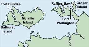
Fort Dundas was a short-lived British settlement on Melville Island between 1824 and 1828 in what is now the Northern Territory of Australia. It was the first of four British settlement attempts in northern Australia before Goyder's survey and establishment of Palmerston, now known as Darwin. The three later attempts were at Fort Wellington, Port Essington and Escape Cliffs.

Bremer Island, or Dhambaliya in the local language is an island in the Arafura Sea, in the northwest of the Gulf of Carpentaria, 3.4 km off the northeast corner of Arnhem Land, Northern Territory, Australia.

Raffles Bay is a bay on the northern coast of the Cobourg Peninsula of the Top End of the Northern Territory of Australia. It was named in 1818 by explorer Phillip Parker King after Sir Thomas Stamford Raffles, the founder of Singapore. It is about 10 km long north to south, 5 km wide at its mouth and 3 km wide at its inland end. It lies about 210 km north-east of Darwin and opens on to the northern end of Bowen Strait, between the Cobourg Peninsula and Croker Island, and the Arafura Sea. It was the site of an abortive attempt to establish the British military outpost and settlement of Fort Wellington, which lasted only two years, from 1827 to 1829. The surrounds of the bay are largely uninhabited; it now lies within the Garig Gunak Barlu National Park.

Escape Cliffs is a place on the northern coast of the Northern Territory of Australia and the site of the fourth of a series of four failed attempts to establish permanent settlement in Australia's Top End. The previous attempts were at Fort Dundas, Fort Wellington and Port Essington. Escape Cliffs lies on the western coast of the Cape Hotham peninsula, and the eastern shore of Adam Bay, near the mouth and estuary of the Adelaide River. It lies about 60 km north-east of Darwin and is located in the Cape Hotham sector of the Djukbinj National Park. There is no road access, though it is sometimes visited by yachts.

The Moreton Bay Penal Settlement operated from 1825 to 1842. It became the city of Brisbane, Queensland, Australia.
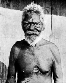
Mildirn, sometimes spelt Medlone, also known as Jack Davis, Old Jack Davis or Port Essington Jack was a well-known Aboriginal leader, translator and advisor for Port Essington, a site of early British settlement in the Northern Territory of Australia.
The Iwaidja are an indigenous Australian people of the Northern Territory.
The following is a timeline of the history of the city of Brisbane, Queensland, Australia.

From the late 1700s until the end of the 19th century, the British Empire established, expanded and maintained a number of colonies on the continent of Australia. These colonies included New South Wales, Van Diemen's Land, Western Australia, South Australia, Victoria and Queensland. Many of these were initially formed as penal settlements, and all were built on land occupied by Indigenous Australians. In order to keep the large number of transported convicts under control, enforce colonial law and to secure the expansion of the colonies from Aboriginal resistance, British armed forces, including the British Army, were deployed and garrisoned in Australia. From 1790 to 1870 over 30 different regiments of the British Army consisting of a combined total of around 20,000 soldiers were based in the Australian British colonies.

