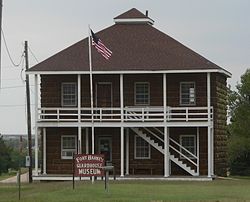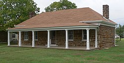
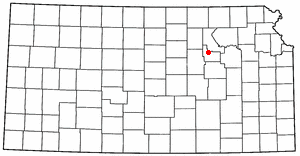
Ellsworth County is a county located in the U.S. state of Kansas. Its county seat and most populous city is Ellsworth. As of the 2020 census, the county population was 6,376. The county was named after Fort Ellsworth.

Kanopolis is a city in Ellsworth County, Kansas, United States. As of the 2020 census, the population of the city was 443. It was built on the site of Fort Harker, a United States Army post that housed infantry and cavalry troops involved in the Indian Wars from 1867 to 1872.
Fort Riley is a United States Army installation located in North Central Kansas, on the Kansas River, also known as the Kaw, between Junction City and Manhattan. The Fort Riley Military Reservation covers 101,733 acres (41,170 ha) in Geary and Riley counties. The portion of the fort that contains housing development is part of the Fort Riley census-designated place, with a residential population of 7,761 as of the 2010 census. The fort has a daytime population of nearly 25,000. The ZIP Code is 66442.
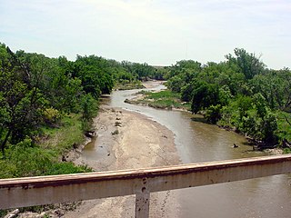
The Smoky Hill River is a 575-mile (925 km) river in the central Great Plains of North America, running through Colorado and Kansas.

Buffalo Soldiers were United States Army regiments composed primarily of African Americans, formed during the 19th century to serve on the American frontier. On September 21, 1866, the 10th Cavalry Regiment was formed at Fort Leavenworth, Kansas. The nickname "Buffalo Soldiers" was purportedly given to the regiment by Native Americans who fought against them in the American Indian Wars, and the term eventually became synonymous with all of the African American U.S. Army regiments established in 1866, including the 9th Cavalry Regiment, 10th Cavalry Regiment, 24th Infantry Regiment, 25th Infantry Regiment and 38th Infantry Regiment.

Fort Leavenworth is a United States Army installation located in Leavenworth County, Kansas, in the city of Leavenworth. Built in 1827, it is the second oldest active United States Army post west of Washington, D.C., and the oldest permanent settlement in Kansas. Fort Leavenworth has been historically known as the "Intellectual Center of the Army."

Fort Larned National Historic Site preserves Fort Larned which operated from 1859 to 1878. It is approximately 5.5 miles (8.9 km) west of Larned, Kansas, United States.

Fort Gibson is a historic military site next to the modern city of Fort Gibson, in Muskogee County Oklahoma. It guarded the American frontier in Indian Territory from 1824 to 1888. When it was constructed, the fort was farther west than any other military post in the United States. It formed part of the north–south chain of forts that was intended to maintain peace on the frontier of the American West and to protect the southwestern border of the Louisiana Purchase. The fort succeeded in its peacekeeping mission for more than 50 years, as no massacres or battles occurred there.

The Battle of Beecher Island, also known as the Battle of Arikaree Fork, was an armed conflict between elements of the United States Army and several of the Plains Native American tribes in September 1868. Beecher Island, on the Arikaree River, then known as part of the North Fork of the Republican River, near present-day Wray, Colorado, was named afterwards for Lieutenant Fredrick H. Beecher, an army officer killed during the battle.
The Department of the Missouri was a command echelon of the United States Army in the 19th century and a sub division of the Military Division of the Missouri that functioned through the Indian Wars.

Fort Hays, originally named Fort Fletcher, was a United States Army fort near Hays, Kansas. Active from 1865 to 1889 it was an important frontier post during the American Indian Wars of the late 19th century. Reopened as a historical park in 1929, it is now operated by the Kansas Historical Society as the Fort Hays State Historic Site.
Galvanized Yankees was a term from the American Civil War denoting former Confederate prisoners of war who swore allegiance to the United States and joined the Union Army. Approximately 5,600 former Confederate soldiers enlisted in the United States Volunteers, organized into six regiments of infantry between January 1864 and November 1866. Of those, more than 250 had begun their service as Union soldiers, were captured in battle, then enlisted in prison to join a regiment of the Confederate States Army. They surrendered to Union forces in December 1864 and were held by the United States as deserters, but were saved from prosecution by being enlisted in the 5th and 6th U.S. Volunteers. An additional 800 former Confederates served in volunteer regiments raised by the states, forming ten companies. Four of those companies saw combat in the Western Theater against the Confederate Army, two served on the western frontier, and one became an independent company of U.S. Volunteers, serving in Minnesota.
The Battle of Middle Boggy Depot, also known as the Battle of Middle Boggy River or simply Battle of Middle Boggy, took place on February 13, 1864 in Choctaw Indian Territory, 4 miles (6.4 km) south of what is now Allen in Pontotoc County, Oklahoma. Advancing down the Dragoon Trail toward Fort Washita, Union Colonel William A. Phillips sent out an advance of approximately 350 men from the 14th Kansas Cavalry and two howitzers to attack a Confederate outpost guarding the Trail's crossing of Middle Boggy River. The Confederate force was led by Captain Jonathan Nail and composed of one company of the First Choctaw and Chickasaw Cavalry, a detachment of the 20th Texas Cavalry and part of the Seminole Battalion of Mounted Rifles. The outpost was about 12 miles (19 km) from Muddy Boggy Depot, which was held by the Confederates. The Encyclopedia of Oklahoma History and Culture says that the battlefield was 15 miles northeast of the depot, whereas the battlefield marker says the distance was 12 miles. The Confederate force at the outpost, consisting of 90 poorly armed men, were caught off guard when Willetts attacked them. Outnumbered and outgunned, the Confederates held off the Union cavalry attack for approximately 30 minutes before retreating to the rest of Lt. Col. John Jumper's Seminole Battalion, who were not at the main skirmish. The Confederates retreated 45 miles (72 km) southwest down the Dragoon Trail. The Union advance continued south toward Ft. Washita the next day, but when the expected reinforcements did not arrive Philips' Expedition into Indian Territory stalled on February 15, near old Stonewall.

Camp Warner was a United States Army outpost in south-central Oregon, United States. Camp Warner was located at two different sites approximately 35 miles (56 km) apart. The Army called both sites Camp Warner. However, the first site became known as Old Camp Warner. It was used as winter quarters in 1866–1867 and then abandoned. The second, more developed site is generally known as Fort Warner, although the Army never officially designated it as a fort. Fort Warner was used as a supply depot and administrative headquarters from 1867 to 1874 during a protracted Army campaign against Northern Paiute bands in Eastern Oregon and Northern California. Today, nothing remains of either Old Camp Warner or Fort Warner.
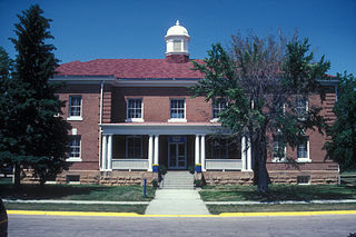
Fort Meade, originally known as Camp Sturgis and later Camp Ruhlen, is a former United States Army post located just east of Sturgis, South Dakota, United States. The fort was active from 1878 to 1944; the cantonment is currently home to a Veterans Health Administration hospital and South Dakota Army National Guard training facilities. Much of the former reservation is now managed by the Bureau of Land Management as the Fort Meade Recreation Area. It is also home of Fort Meade National Cemetery. Fort Meade was established in 1878 to protect illegal white settlements on the Great Sioux Reservation in the northern Black Hills, especially the nearby gold mining area around Deadwood. Several stage and freighting routes passed through Fort Meade en route to Deadwood.

The site of Fort Dodge in the U.S. state of Kansas was originally an old campground for wagons traveling along the Santa Fe Trail, just west of the western junction of the Wet and Dry Routes and near the middle or Cimarron Cutoff. On March 23, 1865, Major General Grenville M. Dodge, who commanded the 11th and 16th Kansas Cavalry Regiments, wrote to Colonel James Hobart Ford to propose establishing a new military post west of Fort Larned. On orders of Col. Ford, Captain Henry Pearce, with Company C, Eleventh Cavalry Regiment, and Company F, Second U.S. Volunteer Infantry, from Fort Larned, occupied and established Fort Dodge on April 10, 1865.
In 1864 Gen. Samuel R. Curtis established a military camp at the Fort Riley-Fort Larned Road crossing of the Smoky Hill River in what is now Ellsworth County, Kans.

Fort Clark was a frontier fort located just off U.S. Route 90 near Brackettville, in Kinney County, Texas, United States. It later became the headquarters for the 2nd Cavalry Division. The Fort Clark Historic District was added to the National Register of Historic Places on December 6, 1979. The Commanding Officer's Quarters at Fort Clark were designated a Recorded Texas Historic Landmark in 1988. The Fort Clark Guardhouse became a Recorded Texas Historic Landmark in 1962. The Fort Clark Officers' Row Quarters were designated a Recorded Texas Historic Landmark in 1991.

Henry Inman was an American soldier, frontiersman, and author. He served the military during the Indian campaigns and the American Civil War, having earned distinction for gallantry on the battlefield. He was commissioned lieutenant general during the Indian wars. He settled in Kansas and worked as a journalist and author of short stories and books of the plains and western frontier. He was a friend and associate of Buffalo Bill and served under General Custer.

The Perry Hodgden House, at 104 W. Main St. in Ellsworth, Kansas, was listed on the National Register of Historic Places in 1973.
