Related Research Articles

McPherson County is a county located in the U.S. state of Kansas. As of the 2020 census, the county population was 30,223. The largest city and county seat is McPherson. The county is named for Civil War General James B. McPherson.

Great Bend is a city in and the county seat of Barton County, Kansas, United States. It is named for its location at the point where the course of the Arkansas River bends east then southeast. As of the 2020 census, the population of the city was 14,733. It is home to Barton Community College.

Pawnee Rock, one of the most famous and beautiful landmarks on the Santa Fe Trail, is located in Pawnee Rock State Park, just north of Pawnee Rock, Kansas, United States. Originally over 150 feet (46 m) tall, railroad construction stripped it of some 15 to 20 feet (6.1 m) in height for road bed material. A memorial monument, picnic area, and pergola have been constructed on the top. From the top of the pergola is a view the Arkansas river valley and the route of the Santa Fe trail. Today it is a prominence rising 50 or 60 feet above the surrounding plains. Matt Field, who traveled the Santa Fe Trail in 1840, later wrote, "Pawnee Rock springs like a huge wart from the carpeted green of the prairie." Traders, soldiers, and emigrants who stopped, carved their names into the brown sandstone. Some of these names are still visible among the graffiti of the more recent visitors.

The Santa Fe Trail was a 19th-century route through central North America that connected Franklin, Missouri, with Santa Fe, New Mexico. Pioneered in 1821 by William Becknell, who departed from the Boonslick region along the Missouri River, the trail served as a vital commercial highway until 1880, when the railroad arrived in Santa Fe. Santa Fe was near the end of El Camino Real de Tierra Adentro, which carried trade from Mexico City.
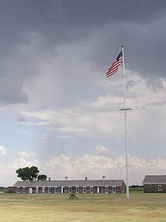
Fort Larned National Historic Site preserves Fort Larned which operated from 1859 to 1878. It is approximately 5.5 miles (8.9 km) west of Larned, Kansas, United States.

Satank was a prestigious Kiowa warrior and medicine man. He was born about 1800, probably in Kansas, and killed June 8, 1871. An able warrior, he became part of the Koitsenko, the society of the bravest Kiowa warriors. He led many raids against the Cheyennes, the Sacs, and the Foxes. As the white settlers' importance increased, he raided settlements, wagon trains, and even army outposts.
The Department of the Missouri was a command echelon of the United States Army in the 19th century and a sub division of the Military Division of the Missouri that functioned through the Indian Wars.

Fort Harker, located in Kanopolis, Kansas, was an active military installation of the United States Army from November 17, 1866 to October 5, 1872. The fortification was named after General Charles Garrison Harker, who was killed in action at the Battle of Kennesaw Mountain in the American Civil War. Fort Harker replaced Fort Ellsworth, which had been located 1.6 km (0.99 mi) from the location of Fort Harker and was abandoned after the new fortifications at Fort Harker were constructed. Fort Harker was a major distribution point for all military points farther west and was one of the most important military stations west of the Missouri River.

The 9th Independent Battery Wisconsin Light Artillery was an artillery battery that served in the Union Army during the American Civil War. It was often referred to as "Lyons' Pinery Battery".
Kansas has always been home to many forts and military posts.

Pierceville is an unincorporated community in Finney County, Kansas, United States. As of the 2020 census, the population of the community and nearby areas was 98. It is located along U.S. Routes 50 and 400, 12 miles (19 km) southeast of Garden City.
The 2nd Regiment Colorado Cavalry was a cavalry regiment that served in the Union Army during the American Civil War.
The Overland Trail was a stagecoach and wagon trail in the American West during the 19th century. While portions of the route had been used by explorers and trappers since the 1820s, the Overland Trail was most heavily used in the 1860s as a route alternative to the Oregon, California, and Mormon trails through central Wyoming. The Overland Trail was famously used by the Overland Stage Company owned by Ben Holladay to run mail and passengers to Salt Lake City, Utah, via stagecoaches in the early 1860s. Starting from Atchison, Kansas, the trail descended into Colorado before looping back up to southern Wyoming and rejoining the Oregon Trail at Fort Bridger. The stage line operated until 1869 when the completion of the First Transcontinental Railroad eliminated the need for mail service via stagecoach.
Fort Aubrey, in eastern Hamilton County, Kansas, was established by the US Army in the 1850s. It originally had no name and was not made a truly permanent post until 1865. It was originally established to serve as a temporary resting place for traveling troops. The location of the fort is based upon a recommendation by François Xavier Aubry, for whom the fort is named.
In spring and summer 1864 Fort Blair, Fort Henning and Fort Insley were constructed to help protect the town and post of Fort Scott from Confederate forces. Fort Insley was named for Capt. Martain H. Insley. It was located just northeast of town, about 1½ blocks northeast of the main part of the post of Fort Scott. It overlooked Buck Run Creek.
The Kansas Soldiers' Home (KSH), located at Fort Dodge, Kansas, was established February 7, 1890. It is under the authority of the Kansas Commission of Veterans' Affairs. It has grown since its inception to include a variety of services.

The site of Fort Dodge in the U.S. state of Kansas was originally an old campground for wagons traveling along the Santa Fe Trail, just west of the western junction of the Wet and Dry Routes and near the middle or Cimarron Cutoff. On March 23, 1865, Major General Grenville M. Dodge, who commanded the 11th and 16th Kansas Cavalry Regiments, wrote to Colonel James Hobart Ford to propose establishing a new military post west of Fort Larned. On orders of Col. Ford, Captain Henry Pearce, with Company C, Eleventh Cavalry Regiment, and Company F, Second U.S. Volunteer Infantry, from Fort Larned, occupied and established Fort Dodge on April 10, 1865.
In 1864 Gen. Samuel R. Curtis established a military camp at the Fort Riley-Fort Larned Road crossing of the Smokey Hill River in what is now Ellsworth County, Kans.

Heizer, also called Heizerton, is an unincorporated community in Barton County, Kansas, United States.

Henry Inman was an American soldier, frontiersman, and author. He served the military during the Indian campaigns and the American Civil War, having earned distinction for gallantry on the battlefield. He was commissioned lieutenant general during the Indian wars. He settled in Kansas and worked as a journalist and author of short stories and books of the plains and western frontier. He was a friend and associate of Buffalo Bill and served under General Custer.
References
- ↑ Bernard Bryan Smyth, The Heart of the New Kansas, 1880, pp 82-88
- ↑ Two good lists of Indian attacks can be found in Ray Schulz, "Indian Depredations near Walnut Creek Crossing", Collections of Barton County Historical Society Vol II No IV, 1965 and Lawrence Hammer, "A History of Fort Zarah 1864-1869", Collections of Barton County Historical Society Vol. III No. 1. Spring 2004
- ↑ Ida Rath, The Rath Trail http://www.kancoll.org/books/rath/rath_ch07.htm
- ↑ George Root "Reminiscences of William Darnell", Kansas Historical Collection, XVII (1926-1928)
- ↑ Louise Barry, "The Ranch at the Walnut Creek Crossing" Kansas Historical Quarterly, 37 Summer 1971 121-147
- ↑ Henry Inman, Along the Old Trail, Tucker-Vernon Publisher, 1910 33
- ↑ Henry Inman, The Old Santa Fe Trail, Macmillan Co. 1897 408-409
- ↑ David Clapsaddle, "Satank, Bane of the Sana Fe Trail" Nov 2004 issue of Wagon Tracks
- ↑ Blackmar, Frank Wilson (1912). Kansas: A Cyclopedia of State History, Embracing Events, Institutions, Industries, Counties, Cities, Towns, Prominent Persons, Etc. Standard Publishing Company. p. 677. ISBN 9780722249055.
- ↑ "Fort Zarah". Archived from the original on 2007-09-27. Retrieved 2007-05-15.
- ↑ Bernard Bryan Smyth, op. cit. p. 88 also Henry Inman Along the Old Trail, p. 117 also “A Brief History of Zarah”, Tom Cooper, Collections of Barton County Historical Society Vol I No ll
- ↑ Barry, op. cit.