
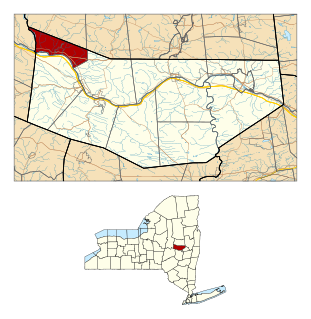
Town of Palatine is a town in Montgomery County, New York, United States. It is located on the north side of the Mohawk River in the northwestern part of the county. The population was 3,240 at the 2010 census, the highest since the 1820s. The name is derived from the Palatinate in the Rhineland, the homeland of the Germans who were the earliest European settlers of this region. Administrative offices of the town are located in Palatine Bridge

Canajoharie is a village in the Town of Canajoharie in Montgomery County, New York, United States. As of the 2010 census, the village had a population of 2,229. The name is said to be a Mohawk language term meaning "the pot that washes itself," referring to the "Canajoharie Boiling Pot," a circular gorge in the Canajoharie Creek, just south of the village.

St. Johnsville is a village in Montgomery County, New York, United States. The population was 1,732 at the 2010 census. Accounts vary as to what the name is derived from, but most accounts credit Alexander St. John, an early surveyor and commissioner, and still others credit an early name for the area, St. John's Church.
St. Johnsville is a town in Montgomery County, New York, United States. The population was 2,631 at the 2010 census. Accounts vary as to the naming of St. Johnsville, but most of them state that the town and its village are named after an early surveyor and commissioner, Alexander St. John. Still others credit the naming of St. Johnsville to a former name for the area, St. John's Church.

Fort York is an early 19th-century military fortification in the Fort York neighbourhood of Toronto, Ontario, Canada. The fort was used to house soldiers of the British Army and the Canadian militia; and to defend the entrance of the Toronto Harbour. The fort features stone-lined earthwork walls and eight historical buildings within them, including two blockhouses. The fort forms a part of Fort York National Historic Site, a 16.6-hectare (41-acre) site that includes the fort, Garrison Common, military cemeteries, and a visitor centre.

The Isthmus of Chignecto is an isthmus bordering the Maritime provinces of New Brunswick and Nova Scotia that connects the Nova Scotia peninsula with North America.

Fort Frederick State Park is a public recreation and historic preservation area on the Potomac River surrounding the restored Fort Frederick, a fortification active in the French and Indian War (1754–1763) and the American Revolutionary War (1775-1783). The state park lies south of the town of Big Pool, Maryland. The Chesapeake and Ohio Canal runs through the park grounds. The site was designated a National Historic Landmark in 1973.

Old Fort Johnson is a historic house museum and historic site at 2 Mergner Road in Fort Johnson, New York. It is the site of Fort Johnson, a two-story stone house originally enclosed in fortifications built by Sir William Johnson about 1749. The fort served as Johnson's home, business office and trading center until 1763 when he moved to Johnson Hall in what is now Johnstown, New York. Sir William's son Sir John Johnson owned the house from 1763 until 1776, when it was confiscated by the local Committee of Safety. The house remains and is owned and operated as a museum by the Montgomery County Historical Society. It was designated a National Historic Landmark in 1972.

Crown Point State Historic Site is the site of a former military stronghold at the south end of the wider part of Lake Champlain. The location is in Essex County, New York, United States. The site is on a peninsula in the town of Crown Point, New York.

Located in the village of Schoharie, Schoharie County New York, the Old Stone Fort was originally built as a Reformed Dutch Church in 1772. With the coming of the American Revolutionary War, the church was enclosed by a log stockade in 1777.

Light's Fort was built in 1742 by Johannes Peter Leicht [John Light] (1682-1758). Light's Fort is the oldest standing building of any kind in the county and city of Lebanon, Pennsylvania. John Light, an immigrant, purchased the land on December 29, 1738, from Caspar Wistar, and wife, Katherine, of the City of Philadelphia, Brass Button Maker, for 82 pounds and 4 shillings. Light's Fort was built in 1742 on a tract of land, which was situated on a branch of the Quittapahilla Creek in Lancaster County at North 11th and Maple Streets. It contained 274 acres including an allowance of 6% for roads together with woods, water courses, etc.

The Conrad Weiser Homestead was the home of Johann Conrad Weiser, who enlisted the Iroquois on the British side in the French and Indian War. The home is located near Womelsdorf, Berks County, Pennsylvania in the United States. A designated National Historic Landmark, it is currently administered as a historic house museum by the Pennsylvania Historical and Museum Commission. The historic site was established in 1923 to preserve an example of a colonial homestead and to honor Weiser, an important figure in the settlement of the colonial frontier.

The Crailo State Historic Site is a historic, fortified brick manor house in Rensselaer, New York which was originally part of a large patroonship held by Kiliaen van Rensselaer (1586–1643). The word Crailo is derived from kraaien bos and refers to van Rensselaer's Estate in Huizen, Holland, which is also named "Crailo". Fort Crailo is listed on the National Register of Historic Places.
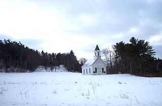
Mohawk Upper Castle Historic District is a historic district in Herkimer County, New York that was declared a National Historic Landmark in 1993. Located south of the Mohawk River, it includes the Indian Castle Church, built in 1769 by Sir William Johnson, British Superintendent of Indian Affairs, as a missionary church for the Mohawk in the western part of their territory; the Brant Family Barn, a rare surviving example of Dutch colonial barns in the Mohawk Valley; as well as important archaeological site areas revealing life in Nowadaga, as the western part of the Mohawk village of Canajoharie was known. The fortified village was called the Upper Castle by European colonists.
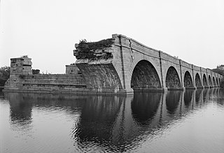
Schoharie Crossing State Historic Site, also known as Erie Canal National Historic Landmark, is a historic district that includes the ruins of the Erie Canal aqueduct over Schoharie Creek, and a 3.5-mile (5.6 km) long part of the Erie Canal, in the towns of Glen and Florida within Montgomery County, New York. It was the first part of the old canal to be designated a National Historic Landmark, prior to the designation of the entire New York State Barge Canal as a NHL in 2017.
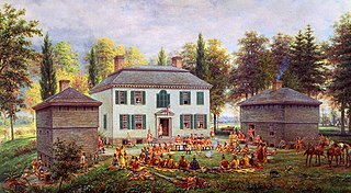
Johnson Hall State Historic Site was the home of Sir William Johnson (1715–1774) an Irish pioneer who became the influential British Superintendent of Indian Affairs in the Province of New York, known for his strong relationship especially with the Mohawk and other Iroquois League nations.
The Battle of Klock's Field, also called the Battle of Failing's Orchard; and occasionally the Battle of Nellis Flatts or the Battle of Stone Arabia, was an encounter between Albany County, New York militia and a British-supported expedition of Indians and Loyalists led by Lieutenant Colonel Sir John Johnson and Captain Joseph Brant.

The Attack on German Flatts was a raid on the frontier settlement of German Flatts, New York during the American Revolutionary War. The attack was made by a mixed force of Loyalists and Iroquois under the overall command of Mohawk leader Joseph Brant, and resulted in the destruction of houses, barns, and crops, and the taking of livestock for the raiders' use. The settlers, warned by the heroic run of Adam Helmer, took refuge in local forts but were too militarily weak to stop the raiders.
The Fulton County Jail, originally the Tryon County Jail, is a historic jail complex located at the corner of Perry and Montgomery Street in Johnstown, Fulton County, New York. The original section was built in 1772-1773 and was placed on the village's highest ground to give a defensive advantage in case of an attack by Native Americans or a war. At the time, is was thought to be one of the strongest defensive position in colonial America, due to its placment and the thick wall, which would deflect everything but the very strongest artillery.

Heinrich Zeller House, also known as Fort Zeller and Zeller's Fort, is a historic 1 1/2-story building that has served as a fort, block house and residence. The historic structure is located in Millcreek Township, Lebanon County, Pennsylvania.


