St. Johnsville, New York

Last updated

St. Johnsville
Montgomery County NY St. Johnsville town highlighted.svg
Location in Montgomery County and the state of New York.
New York in United States (US48).svg
Location of New York in the United States
Coordinates: 42°59′59″N74°40′42″W / 42.99972°N 74.67833°W / 42.99972; -74.67833
CountryUnited States
State New York
County Montgomery
Government
   Town Supervisor Phoebe Sitterly (R)
  • Ronald R. Millington (R)
  • Ronald A. Hezel (R)
  • William A. Farber (R)
  • Susan Handy (R)
Area
[1]
  Total17.36 sq mi (44.96 km2)
  Land16.84 sq mi (43.62 km2)
  Water0.52 sq mi (1.34 km2)
Population
 (2010)
  Total2,631
  Estimate 
(2016) [2]
2,535
  Density150.52/sq mi (58.12/km2)
Time zone EST
  Summer (DST) EDT
ZIP code
13452 [3]
FIPS code 36-057-64650

St. Johnsville is a town in Montgomery County, New York, United States. The population was 2,631 at the 2010 census. Accounts vary as to the etymology of St. Johnsville, but most of them state that the town and its village are named after an early surveyor and commissioner, Alexander St. John. [4] Still others credit the naming of St. Johnsville to a former name for the area, St. John's Church. [5]

Contents

The Town of St. Johnsville is in the northwestern part of the county. The town contains a village, also called St. Johnsville. Both town and village are approximately halfway between Utica and Amsterdam.

The Erie Canal, as part of the Mohawk River, is at the town's southern border.

History

Perspective map of St. Johnsville with list of landmarks published in 1890 by L.R. Burleigh St. Johnsville, N.Y. LOC 75694842.tif
Perspective map of St. Johnsville with list of landmarks published in 1890 by L.R. Burleigh

The town was first settled around 1725. The territory was part of the Palatine District.

In 1769, Sir William Johnson built a church in the town for the benefit of his Indian allies.

A brief skirmish was fought in the town in 1780 near Fort Klock, a fortified house.

The Town of St. Johnsville was formed in 1838 from the Town of Oppenheim ( which then became part of the newly created Fulton County ).

In 1857, the community of St. Johnsville set itself off from the town by incorporating as a village.

According to the Enterprise and News, November 17, 1937, by 1934, Mr. and Mrs. Joseph H. Reaney had given 120 acres of land to the Village of Saint Johnsville. This land was named Klock Park after Dr. Charles M. Klock, a highly regarded local physician. Today the H.C Smith Benefit Club utilizes the building to host many community events.

The First Methodist Episcopal Church of St. Johnsville, Fort Klock, Enlarged Double Lock No. 33 Old Erie Canal, Nellis Tavern, and Margaret Reaney Memorial Library are listed on the National Register of Historic Places. [6] [7] [8]

Geography

According to the United States Census Bureau, the town has a total area of 17.4 square miles (45.0 km2), of which 16.8 square miles (43.6 km2) is land and 0.5 square mile (1.4 km2) (3.11%) is water.

The Mohawk River forms the southern town line. The northern town boundary is the border of Fulton County, and the western town line is the border of Herkimer County, marked by East Canada Creek.

St. Johnsville is the smallest town in the county (by area).

NY-5 is an east-west highway in the southern part of the town. The western terminus of NY-67 is at NY-5, east of St. Johnsville village. The southern terminus of NY-331 is near the northwestern part of the town.

Demographics

Historical population
CensusPop.Note
1840 1,923
1850 1,627−15.4%
1860 1,6883.7%
1870 2,18929.7%
1880 2,062−5.8%
1890 2,0810.9%
1900 2,67428.5%
1910 3,36926.0%
1920 3,123−7.3%
1930 3,000−3.9%
1940 2,974−0.9%
1950 2,934−1.3%
1960 2,9580.8%
1970 2,915−1.5%
1980 3,0645.1%
1990 2,773−9.5%
2000 2,567−7.4%
2010 2,6312.5%
2016 (est.)2,535 [2] −3.6%
U.S. Decennial Census [9]

As of the census [10] of 2000, there were 2,565 people, 1,043 households, and 658 families residing in the town. The population density was 152.4 inhabitants per square mile (58.8/km2). There were 1,170 housing units at an average density of 69.5 per square mile (26.8/km2). The racial makeup of the town was 98.67% White, 0.08% Black or African American, 0.39% Native American, 0.16% Asian, 0.04% Pacific Islander, 0.12% from other races, and 0.55% from two or more races. Hispanic or Latino of any race were 1.36% of the population.

There were 1,043 households, out of which 27.8% had children under the age of 18 living with them, 45.7% were married couples living together, 12.0% had a female householder with no husband present, and 36.9% were non-families. 31.5% of all households were made up of individuals, and 17.5% had someone living alone who was 65 years of age or older. The average household size was 2.35 and the average family size was 2.91.

In the town, the population was spread out, with 23.4% under the age of 18, 8.0% from 18 to 24, 24.1% from 25 to 44, 22.4% from 45 to 64, and 22.1% who were 65 years of age or older. The median age was 41 years. For every 100 females, there were 91.6 males. For every 100 females age 18 and over, there were 87.8 males.

The median income for a household in the town was $30,719, and the median income for a family was $39,830. Males had a median income of $25,000 versus $21,010 for females. The per capita income for the town was $15,116. About 9.5% of families and 12.4% of the population were below the poverty line, including 20.4% of those under age 18 and 6.5% of those age 65 or over.

Communities and locations in the Town of St. Johnsville

Related Research Articles

<span class="mw-page-title-main">Greenport, Columbia County, New York</span> Town in New York, United States

Greenport is a town in Columbia County, New York, United States. The population was 4,165 at the 2010 census. The town is on the western border of the county and surrounds the city of Hudson on three sides. US 9 passes through the town.

<span class="mw-page-title-main">Ephratah, New York</span> Town in New York, United States

Ephratah is a town in Fulton County, New York, United States. The population was 1,682 at the 2010 census. It is named after Ephrath, a biblical town in what is now Israel.

Oppenheim is a town in Fulton County, New York, United States. The town is in the southwestern corner of the county and is east of Utica. The population was 1,924 at the 2010 census.

<span class="mw-page-title-main">Danube, New York</span> Town in New York, United States

Danube is a town in Herkimer County, New York, United States. The population was 801 at the 2020 census, down from 1,039 in 2010. Early Palatine German immigrants in the eighteenth century named the town after the Danube River in Europe.

<span class="mw-page-title-main">German Flatts, New York</span> Town in Herkimer County, New York, US

German Flatts is a town in Herkimer County, New York, United States. The population was 12,263 at the 2020 census down from 13,258 at the 2010 census.

<span class="mw-page-title-main">Manheim, New York</span> Town in New York, United States

Manheim is a town in Herkimer County, New York, United States. The population was 3,334 at the 2010 census. The town name is derived from Mannheim in Baden, Germany.

<span class="mw-page-title-main">Charleston, New York</span> Town in Montgomery County, NY

Charleston is a town in Montgomery County, New York, United States. The population was 1,373 at the 2010 census. The town was named for Charles Van Epps, an early settler.

<span class="mw-page-title-main">Glen, New York</span> Town in New York, United States

Glen is a town in Montgomery County, New York, United States. The population was 2,507 at the 2010 census. The town was named after Jacob Glen, an early landowner.

<span class="mw-page-title-main">Mohawk, Montgomery County, New York</span> Town in New York, United States

Mohawk is a town in Montgomery County, New York, United States. The population was 3,844 at the 2010 census.

<span class="mw-page-title-main">Palatine, New York</span> Town in New York, United States

Town of Palatine is a town in Montgomery County, New York, United States. It is located on the north side of the Mohawk River in the northwestern part of the county. The population was 3,240 at the 2010 census, the highest since the 1820s. The name is derived from the Palatinate in the Rhineland, the homeland of the Germans who were the earliest European settlers of this region. Administrative offices of the town are located in Palatine Bridge

<span class="mw-page-title-main">Whitestown, New York</span> Town in New York, United States

Whitestown is a town in Oneida County, New York, United States. The population was 18,667 at the 2010 census. The name is derived from Judge Hugh White, an early settler. The town is immediately west of Utica and the New York State Thruway passes across the town. The offices of the town of Whitestown are in the Village of Whitesboro.

<span class="mw-page-title-main">Hartwick, New York</span> Town in New York, United States

Hartwick is a town located in Otsego County, New York, United States. As of the 2010 census, the town had a population of 2,110. The Town of Hartwick is located in the middle of the county, southwest of the Village of Cooperstown.

<span class="mw-page-title-main">Glenville, New York</span> Town in New York, United States

Glenville is a town in Schenectady County, New York, United States. It was incorporated in 1821 from Schenectady. As of the 2020 census, the town population was 29,326.

<span class="mw-page-title-main">Jefferson, New York</span> Town in Schoharie County, New York, US

Jefferson is a town in Schoharie County, New York, United States. The population was 1,333 at the 2020 census. The town is on the southwestern border of the county and is east of Oneonta.

Tioga is a town in Tioga County, New York, United States. The population was 4,455 at the 2020 census. The town is in the southwestern part of the county and lies between Elmira and Binghamton. Tioga is situated in the Southern Tier District of New York.

<span class="mw-page-title-main">Frankfort, New York</span> Town in New York, United States

Frankfort is a town in Herkimer County, New York, United States. The town is named after one of its earliest settlers, Lawrence (Lewis) Frank. The town of Frankfort includes a village, also called Frankfort. Frankfort is located east of Utica, and the Erie Canal passes along its northern border. At the time of the 2020 census, the population was 7,011, down from 7,636 in 2010.

<span class="mw-page-title-main">Amsterdam (town), New York</span> Town in New York, United States

Amsterdam is a town in Montgomery County, New York, United States. The population was 5,566 at the 2010 census. The town is named after Amsterdam, the capital of the Netherlands.

<span class="mw-page-title-main">Canajoharie (village), New York</span> Village in New York, United States

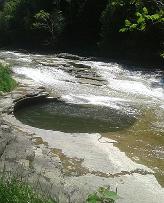
Canajoharie is a village in the Town of Canajoharie in Montgomery County, New York, United States. As of the 2010 census, the village had a population of 2,229. The name is said to be a Mohawk language term meaning "the pot that washes itself," referring to the "Canajoharie Boiling Pot," a circular gorge in the Canajoharie Creek, just south of the village.

<span class="mw-page-title-main">Canajoharie, New York</span> Town in New York, United States

Canajoharie is a town in Montgomery County, New York, United States. The population was 3,730 in 2010. Canajoharie is located south of the Mohawk River on the southern border of the county. The Erie Canal passes along the northern town line. There is also a village of Canajoharie in the town. Both are east of Utica and west of Amsterdam.

St. Johnsville is a village in Montgomery County, New York, United States. The population was 1,732 at the 2010 census. Accounts vary as to the etymology of the name, but most of these credit Alexander St. John, an early surveyor and commissioner, while still others credit an early name for the area, St. John's Church.

References

  1. "2016 U.S. Gazetteer Files". United States Census Bureau. Retrieved July 5, 2017.
  2. 1 2 "Population and Housing Unit Estimates" . Retrieved June 9, 2017.
  3. "Saint Johnsville ZIP Code". zipdatamaps.com. 2022. Retrieved November 11, 2022.
  4. Zurlo, Sam (April 15, 1996). "Area place names reflect local history and personalities". The Daily Gazette . pp. B5. Retrieved April 23, 2015.
  5. "Which came first?".
  6. "National Register Information System". National Register of Historic Places . National Park Service. March 13, 2009.
  7. "National Register of Historic Places Listings". Weekly List of Actions Taken on Properties: 4/16/12 through 4/20/12. National Park Service. April 27, 2012.
  8. "National Register of Historic Places Listings". Weekly List of Actions Taken on Properties: 2/04/13 through 2/08/13. National Park Service. February 15, 2013.
  9. "Census of Population and Housing". Census.gov. Retrieved June 4, 2015.
  10. "U.S. Census website". United States Census Bureau . Retrieved January 31, 2008.