St. Johnsville (village), New York

Last updated
St. Johnsville, New York
USA New York location map.svg
Red pog.svg
St. Johnsville, New York
Location within the state of New York
Coordinates: 42°59′59″N74°40′42″W / 42.99972°N 74.67833°W / 42.99972; -74.67833 Coordinates: 42°59′59″N74°40′42″W / 42.99972°N 74.67833°W / 42.99972; -74.67833
Country United States
State New York
County Montgomery
Area
[1]
  Total0.88 sq mi (2.28 km2)
  Land0.88 sq mi (2.27 km2)
  Water0.00 sq mi (0.00 km2)
Elevation
328 ft (100 m)
Population
 (2020)
  Total1,643
  Density1,871.30/sq mi (722.90/km2)
Time zone UTC-5 (Eastern (EST))
  Summer (DST) UTC-4 (EDT)
FIPS code 36-64639
GNIS feature ID0963694

St. Johnsville is a village in Montgomery County, New York, United States. The population was 1,732 at the 2010 census. Accounts vary as to the etymology of the name, but most of these credit Alexander St. John, an early surveyor and commissioner, while still others credit an early name for the area, St. John's Church. [2]

Contents

The Village of St. Johnsville is in the southern part of the Town of St. Johnsville and lies between Utica and Amsterdam. In 2019, almost the entire village was listed on the National Register of Historic Places as the St. Johnsville Historic District. [3]

History

The area was within the territory of the Mohawk tribe when Europeans first entered the Mohawk Valley. Palatine Germans began settling the area in the early 18th century.

The community was first settled circa 1775.

A small battle was fought during the American Revolution in 1780 near Fort Klock, which lies to the east of St. Johnsville.

St. Johnsville village was incorporated in 1857.


Teddy Roosevelt's Campaign Speech on October 12, 1914 Saint Johnsville, NY Teddy Roosevelt's Campaign Speech Saint Johnsville, NY.jpg
Teddy Roosevelt’s Campaign Speech on October 12, 1914 Saint Johnsville, NY
Teddy Roosevelt's Campaign Speech on October 12, 1914 Saint Johnsville, NY Teddy Roosevelt in Saint Johnsville, NY.jpg
Teddy Roosevelt’s Campaign Speech on October 12, 1914 Saint Johnsville, NY

On October 12, 1914, former President Theodore Roosevelt arrived from the west by auto caravan at Allter’s corner in St. Johnsville (where Stewart’s is today). He spoke from an auto on behalf of the candidacy of Progressive Party candidate for governor, Frederick Davenport. Local residents surrounded his car on all sides. Roosevelt’s theme was that people should be wary of the old political parties and get rid of Albany party bosses Barnes and Murphy, who were in collusion with one another. The Enterprise said that Davenport was the more impressive speaker as Roosevelt “is evidently unable to cope with outdoor activities at the present time.” The auto caravan moved on, heading for Albany. Davenport lost in November, Roosevelt chose not to run for President in 1916, and the Progressive Party faded away. Governor Franklin D. Roosevelt stopped his car there (the old store had been razed by then) in the fall of 1930 and made a brief address about farm relief and the need for a $50 million bond issue for prisons and to care for the insane. Future Governor Herbert Lehman also spoke to the crowd. Future Governor Thomas Dewey stopped at the Shell station in June, 1941, and then visited Pietrocini’s barber shop.


On June 28, 2006, St. Johnsville faced its worst flood in one hundred years.

The Bates-Englehardt Mansion, Stone Grist Mill Complex, and United States Post Office are listed on the National Register of Historic Places. [4] The Margaret Reaney Memorial Library was added in 2012.

In 2016, St. Johnsville's first organic chicken farm, Simple Coop Organics, opened. Simple Coop invested in the community with scenic rental properties.

Geography

St. Johnsville is located at 42°59′58″N74°40′42″W / 42.99944°N 74.67833°W / 42.99944; -74.67833 (42.999674, -74.678386). [5]

According to the United States Census Bureau, the village has a total area of 0.9 square mile (2.2 km2), all land.

The village is on the north bank of the Mohawk River and the Erie Canal. Zimmermann Creek, a tributary of the Mohawk, flows through the village.

New York State Route 5 passes through the village as Main Street.

Demographics

Historical population
CensusPop.Note
1870 1,376
1880 1,072−22.1%
1890 1,26317.8%
1900 1,87348.3%
1910 2,53635.4%
1920 2,469−2.6%
1930 2,273−7.9%
1940 2,2830.4%
1950 2,210−3.2%
1960 2,196−0.6%
1970 2,089−4.9%
1980 1,974−5.5%
1990 1,825−7.5%
2000 1,685−7.7%
2010 1,7322.8%
2020 1,643−5.1%
U.S. Decennial Census [6]

As of the census [7] of 2000, there were 1,685 people, 693 households, and 410 families residing in the village. The population density was 1,967.3 people per square mile (756.5/km2). There were 774 housing units at an average density of 903.7 per square mile (347.5/km2). The racial makeup of the village was 98.87% White, 0.12% Black or African American, 0.53% Native American, 0.18% Asian, and 0.30% from two or more races. Hispanic or Latino of any race were 1.31% of the population.

There were 693 households, out of which 24.8% had children under the age of 18 living with them, 41.1% were married couples living together, 12.8% had a female householder with no husband present, and 40.8% were non-families. 35.8% of all households were made up of individuals, and 20.5% had someone living alone who was 65 years of age or older. The average household size was 2.26 and the average family size was 2.90.

In the village, the population was spread out, with 22.2% under the age of 18, 8.3% from 18 to 24, 23.2% from 25 to 44, 21.4% from 45 to 64, and 24.9% who were 65 years of age or older. The median age was 42 years. For every 100 females, there were 87.0 males. For every 100 females age 18 and over, there were 83.1 males.

The median income for a household in the village was $28,043, and the median income for a family was $37,431. Males had a median income of $28,523 versus $21,115 for females. The per capita income for the village was $14,467. About 11.6% of families and 14.4% of the population were below the poverty line, including 22.7% of those under age 18 and 7.4% of those age 65 or over.

Related Research Articles

<span class="mw-page-title-main">Montgomery County, New York</span> County in New York, United States

Montgomery County is a county in the U.S. state of New York. As of the 2020 census, the population was 49,532. The county seat is Fonda. The county was named in honor of Richard Montgomery, an American Revolutionary War general killed in 1775 at the Battle of Quebec.

<span class="mw-page-title-main">Clermont, Iowa</span> City in Iowa, United States

Clermont is a city in Fayette County, Iowa, United States. The population was 586 at the 2020 census. Clermont is home to Montauk, the mansion of former Iowa governor William Larrabee, along with much historic architecture. Scenes for the movie The Straight Story were filmed here.

<span class="mw-page-title-main">Strathmoor Village, Kentucky</span> City in Kentucky, United States

Strathmoor Village is a home rule-class city in Jefferson County, Kentucky, United States. The population was 648 at the 2010 census.

Davenport is a town in Delaware County, New York, United States. The population was 2,965 at the 2010 census. The town is in the northeastern part of the county.

Ephratah is a town in Fulton County, New York, United States. The population was 1,682 at the 2010 census. It is named after Ephrath, a biblical town in what is now Israel.

Oppenheim is a town in Fulton County, New York, United States. The town is in the southwestern corner of the county and is east of Utica. The population was 1,924 at the 2010 census.

Tannersville is a village in Greene County, New York, United States. The village is in the north-central part of the town of Hunter on Route 23A. The population was 539 at the 2010 census, up from 448 in 2000.

<span class="mw-page-title-main">Manheim, New York</span> Town in New York, United States

Manheim is a town in Herkimer County, New York, United States. The population was 3,334 at the 2010 census. The town name is derived from Mannheim in Baden, Germany.

<span class="mw-page-title-main">Charleston, New York</span> Town in Montgomery County, NY

Charleston is a town in Montgomery County, New York, United States. The population was 1,373 at the 2010 census. The town was named for Charles Van Epps, an early settler.

<span class="mw-page-title-main">Fonda, New York</span> Village in New York, United States

Fonda is a village in and the county seat of Montgomery County, New York, United States. The population was 795 at the 2010 census. The village is named after Douw Fonda, a Dutch-American settler who was killed and scalped in 1780, during a Mohawk raid in the Revolutionary War, when the tribe was allied with the British.

Fort Johnson is a village in Montgomery County, New York, United States located on the north side of the Mohawk River in the town of Amsterdam. The population was 490 at the 2010 census.

Fort Plain is a village in Montgomery County, New York, United States. As of the 2010 census, the village population was 2,322. The village is named after a fort built during the American Revolution at the junction of the Mohawk River and its tributary Otsquago Creek.

Fultonville is a village in Montgomery County, New York, United States. The village is named after Robert Fulton, inventor of the steamboat.

<span class="mw-page-title-main">Glen, New York</span> Town in New York, United States

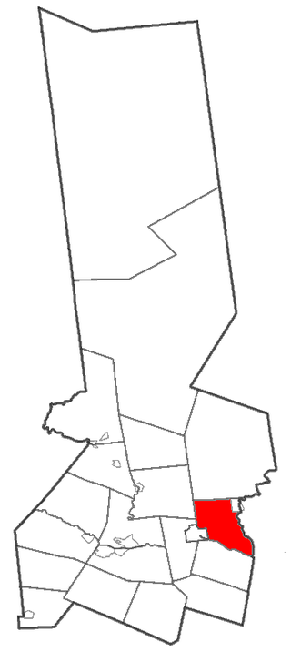
Glen is a town in Montgomery County, New York, United States. The population was 2,507 at the 2010 census. The town was named after Jacob Glen, an early landowner.

Nelliston is a village in Montgomery County, New York, United States. The population was 596 at the 2010 census. The name is from members of the Nellis family.

<span class="mw-page-title-main">Palatine, New York</span> Town in New York, United States

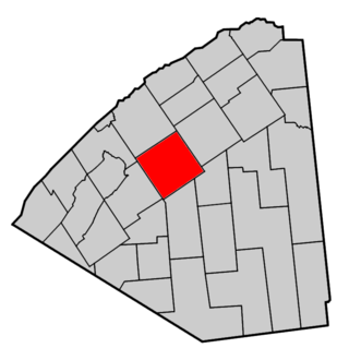
Town of Palatine is a town in Montgomery County, New York, United States. It is located on the north side of the Mohawk River in the northwestern part of the county. The population was 3,240 at the 2010 census, the highest since the 1820s. The name is derived from the Palatinate in the Rhineland, the homeland of the Germans who were the earliest European settlers of this region. Administrative offices of the town are located in Palatine Bridge

Palatine Bridge is a village in Montgomery County, New York, United States. The population was 737 at the 2010 census. The basis of the name is the community's location in a region settled by Palatine Germans. The Village of Palatine Bridge is in the Town of Palatine. The community is in the western part of the county, west of Amsterdam.

<span class="mw-page-title-main">Richfield Springs, New York</span> Village in Otsego County, New York, US

Richfield Springs is a village located in the Town of Richfield, on the north-central border of Otsego County, New York, United States. The population was 1,264 at the 2010 census. The name is derived from local sulfur springs.

<span class="mw-page-title-main">St. Johnsville, New York</span> Town in New York, United States

St. Johnsville is a town in Montgomery County, New York, United States. The population was 2,631 at the 2010 census. Accounts vary as to the etymology of St. Johnsville, but most of them state that the town and its village are named after an early surveyor and commissioner, Alexander St. John. Still others credit the naming of St. Johnsville to a former name for the area, St. John's Church.

<span class="mw-page-title-main">Canton, New York</span> Town in New York, United States

Canton is an incorporated town in St. Lawrence County, New York. The population was 11,638 at the time of the 2020 census. The town contains two villages: one also named Canton, the other named Rensselaer Falls. The town is named after the great port of Canton in China. Canton is the home of St. Lawrence University and the State University of New York at Canton. The Canton Central School District is based in the village of Canton.

References

  1. "ArcGIS REST Services Directory". United States Census Bureau. Retrieved September 20, 2022.
  2. "Which came first?".
  3. "Weekly List 20190405". U.S. National Park Service. April 5, 2019. Retrieved April 8, 2019.
  4. "National Register Information System". National Register of Historic Places . National Park Service. March 13, 2009.
  5. "US Gazetteer files: 2010, 2000, and 1990". United States Census Bureau. 2011-02-12. Retrieved 2011-04-23.
  6. "Census of Population and Housing". Census.gov. Retrieved June 4, 2015.
  7. "U.S. Census website". United States Census Bureau . Retrieved 2008-01-31.