Fort Laramie National Historic Site

Last updated
Fort Laramie National Historic Site
Fort Laramie NHS-Gate.jpg
USA Wyoming relief location map.svg
Red pog.svg
Usa edcp relief location map.png
Red pog.svg
Location Goshen County, Wyoming, USA
Nearest city Torrington, Wyoming
Coordinates 42°12′33″N104°32′9.1″W / 42.20917°N 104.535861°W / 42.20917; -104.535861
Area833 acres (337 ha)
EstablishedMarch 4, 1931
Visitors46,455(in 2005)
Governing body National Park Service
Website Fort Laramie National Historic Site
Fort Laramie National Historic Site
Nearest city Fort Laramie, Wyoming
Area536 acres (217 ha) [1]
Built1834 (1834)
Built byUS Army Corps of Engineers
ArchitectUS Army Corps of Engineers
Architectural styleLime grout construction
NRHP reference No. 66000755 [2]
Added to NRHPOctober 15, 1966

Fort Laramie (founded as Fort William and known for a while as Fort John) was a significant 19th-century trading post, diplomatic site, and military installation located at the confluence of the Laramie and the North Platte Rivers. They joined in the upper Platte River Valley in the eastern part of the present-day U.S. state of Wyoming. The fort was founded as a private trading-post in the 1830s to service the overland fur trade; in 1849, it was purchased by the United States Army. The site was located east of the long climb leading to the best and lowest crossing-point over the Rocky Mountains at South Pass and became a popular stopping-point for migrants on the Oregon Trail. Along with Bent's Fort on the Arkansas River, the trading post and its supporting industries and businesses were the most significant economic hub of commerce in the region.

Contents

Fort William was founded by William Sublette and his partner Robert Campbell in 1834. In the spring of 1835, Sublette sold the fort to Thomas Fitzpatrick, a local fur trader. After a rendezvous in 1836, it was sold to the American Fur Company, which still had a virtual monopoly on the western fur trade. Starting as early as the fall of 1840, the American Fur Company began competing with the newly-established Fort Platte, built by Lancaster Lupton about a mile away from Fort William.

The American Fur Company hired workers from Santa Fe to construct an adobe fort to replace Fort William. This fort was named Fort John, after John Sarpy, a partner in the company. In 1849, the U.S. Army purchased the fort as a post to protect the many wagon trains of migrant travelers on the Oregon Trail, and the subsidiary northern emigrant trails which split off further west. These included the California and Mormon Trails. The middle reaches of the Mormon trail stayed on the north banks of the Platte and North Platte rivers, and merged with the other emigrant trails heading west over the continental divide from Fort John-Laramie. The name "Fort Laramie" gradually came into use, likely as a convenient shortening of "Fort John at the Laramie River".

The remaining structures are preserved as the Fort Laramie National Historic Site by the National Park Service.

History

Name

Interior of the original Fort Laramie as it looked prior to 1840. Painting from memory by Alfred Jacob Miller. Alfred Jacob Miller - Interior of Fort Laramie - Walters 371940150.jpg
Interior of the original Fort Laramie as it looked prior to 1840. Painting from memory by Alfred Jacob Miller.

In 1815 or 1816, Jacques La Ramee and a small group of fellow trappers settled in the area where Fort Laramie would later be located. He went out alone to trap in 1819 or 1820 and was never seen again. Arapahoe Indians were accused of killing La Ramee and burying his body in a beaver dam. The river was named "Laramie" in his honor, and later settlers used this name for the Laramie Mountains, the fort, and the towns of Laramie, Wyoming and Fort Laramie, Wyoming. [3] [4]

The fur trade

Fort William, the first Fort Laramie, as it looked prior to 1840. Painting from memory by Alfred Jacob Miller Alfred Jacob Miller - Fort Laramie - Walters 37194049.jpg
Fort William, the first Fort Laramie, as it looked prior to 1840. Painting from memory by Alfred Jacob Miller

The original fort was constructed in the 1830s, probably in 1833–1834 by William Sublette and Robert Campbell. The overland fur trade was still prosperous, when Jim Bridger and Tom Fitzpatrick bought the place. [5] [6]

The fort was located near the confluence of two rivers, so it commanded a broad plain with water on two sides; these formed a partial natural moat. In addition, the nearby confluence of the North Platte's waters had a ford easily used by travelers on what later became the northern overland emigrant trails following the North Platte River west from Nebraska. With the opening of the Mormon Trail on the north bank of the Platte and North Platte, the fort was a junction for westbound travelers. It was an anchor roughly a quarter of the way to either California or Oregon on the famous Oregon Trail. To the west, the common trail leaving Fort John-Laramie later spins off to the Mormon and California trails further west along the road to the Rogue River Valley. The main trail passed northwest to Oregon's Willamette Valley and Oregon City.

One of the early principal owner-trappers was William Sublette, and the fort was called Fort William [7] before being sold to the American Fur Company in 1841. (John Jacob Astor, the founder, had left his company a decade before.) The name was changed to Fort John after John Sarpy, a partner in the company. [8] The 1846 treaties established relatively stable western territories after viable routes west had become well published. By the time the westward migration along the Oregon Trail had markedly increased, the U.S. Army had become tenants in the fort as well. The fort was located along the Laramie River just south of its mouth onto the North Platte River.

Fort John (Fort Laramie) was originally built of logs in 1834, then rebuilt in adobe in 1841. This digital reconstruction from a National Park Service/CyArk project is based on archaeological data, descriptions, and illustrations from the period when the Fort still stood. It shows the south and east facades of the high-walled Fort John. As a private trading post it was fortified chiefly to prevent theft of the valuable furs. The name Fort John fell into disuse following the military takeover of the Fort in 1849, and disappeared from records by 1860. Fort laramie cyark final.jpg
Fort John (Fort Laramie) was originally built of logs in 1834, then rebuilt in adobe in 1841. This digital reconstruction from a National Park Service/CyArk project is based on archaeological data, descriptions, and illustrations from the period when the Fort still stood. It shows the south and east facades of the high-walled Fort John. As a private trading post it was fortified chiefly to prevent theft of the valuable furs. The name Fort John fell into disuse following the military takeover of the Fort in 1849, and disappeared from records by 1860.

On the opposite bank, the town of Fort Laramie, developed (both were later renamed to match the river's eponym). Geographically, the site is situated just east of the steeper foothills terrain to the west (sometimes called "High Plains") that ascends to the east side of the Rocky Mountains proper. This ascent was among the few roadways accessible by the wagons pioneers used to the west. It passed through the continental divide and reached the west slopes of the Rockies along a network of river valleys connecting to the far west via South Pass near the head waters of the North Platte. The strategic site on the eastern plains also had large grazing areas, where migrants could rest their draft animals before tackling the mountains. People could set up camps, do laundry, and heal before beginning anew the rigors of the westward trail.

In 1845, the nearby Fort Bernard was established about 8 miles (13 km) east, farther down the North Platte River, in hopes of getting some of the growing Emigrant Trail trade with western bound wagon trains. This much smaller fort undersold the Laramie operation. It offered a connection south via a crude mule-train road to the Santa Fe Trail via Colorado. Fort Bernard burnt down in 1866, and was never rebuilt. [9] Only a few years later the transcontinental railway joined the two American sea coasts and train travel largely replaced the overland travel along the Emigrant Trails.

Frontier army post

Fort Laramie, 1858. By Samuel C. Mills. This year, gold was discovered at Cherry Creek near Denver, prompting the Colorado gold rush. Even at a distance of more than 200 miles (320 km) from Denver, Fort Laramie became one of these miners' major connections to the world back east. FortLaramie1858.jpg
Fort Laramie, 1858. By Samuel C. Mills. This year, gold was discovered at Cherry Creek near Denver, prompting the Colorado gold rush. Even at a distance of more than 200 miles (320 km) from Denver, Fort Laramie became one of these miners' major connections to the world back east.

The fort was purchased from Bruce Husband, a member of the American Fur Company, for $4,000 in June 1849 by U.S. Army Lt. Daniel P. Woodbury on behalf of the United States Government. Three companies of cavalry arrived at the fort that same month, and Company 'G', 6th Infantry, which was the post's permanent garrison for many years, arrived on August 12, 1849. [7]

By 1849, gold seekers had joined the Oregon-bound settlers and Mormons heading to Utah, and westward travelers were estimated to number between 20,000 and 40,000 in 1849. The fort itself occupied a location where the westward trail diverged in the direction of either Oregon, Salt Lake City or California. Based on contemporary accounts travelers would remain at the fort several days to mail letters, exchange or purchase cattle, replenish their provisions and reset wagon tires. [10]

The fort was taken over by the Army largely to protect and supply emigrants along the emigrant trails. In 1851, the first Treaty of Fort Laramie was signed, [5] :168–182 resulting in relatively peaceful relations between the whites and the Native Americans during the 1850s, though troops from the fort made up the small force that was killed during the Grattan massacre of 1854 under the command of Second Lieutenant John Lawrence Grattan. During the increasing strife of the 1860s, the fort took on a more military posture.

Fort Laramie was never seriously threatened by Indian attacks during the quarter-century of intermittent warfare sparked by the Grattan massacre. However, a number of civilians were killed in the immediate area and their property destroyed or stolen during this period of hostilities on the plains. The last known death occurred in March 1877 on the Big Bitter Cottonwood Creek. [11]

The earliest surviving photograph of Fort Laramie, taken in 1858 by Samuel C. Mills, shows the remains of the old adobe walled fur trade fort (Fort John) flanked by a cluster of scattered wood and adobe buildings around the parade grounds.

Architecture

After Fort Laramie was purchased by the military on June 26, 1849, numerous buildings were constructed in the following years. As construction began many different factors were hindering progress. Amongst these issues included a lack of laborers, the cold winters, lack of water, and a limited supply of wood and stone in the surrounding area. One solution to these issues was the use of adobe bricks in building. Adobe bricks were a cheaper material that could provide needed insulation in the cold climate. Alongside adobe bricks, many buildings are made using concrete and some wood use as well. This use of multiple building materials gives Fort Laramie a unique aesthetic [12]

Built in 1849, Old Bedlam is the oldest known U.S. military structure in Wyoming and Fort Laramie's most commonly noted building. Old Bedlam served as the original officer quarters for Fort Laramie. It was used by officers of various rank and marital status, since no other housing was yet available. Old Bedlam offered very little privacy utilizing public kitchen areas and soldiers often sharing rooms. In 1881 Old Bedlam was turned into a duplex. [13]

Also originally built in 1849 was the Post Traders store. This store provided supplies for all sorts of people including the Army, Native Americans, and pioneers traveling west. Throughout the years the fort was running, numerous additions were added to the Post Traders store and complex. In 1852 the northern section was built from stone, this became the store headquarters. Additions were made again in 1883 to serve as a bar and officers club housing. [13]

The First Hospital in Fort Laramie was built from adobe bricks with a log roof in 1856. It had two rooms with eight beds each. The First Hospital was expanded in 1858 with an additional room, kitchen, dinning, and laundry area. Then in 1871 a new hospital was built in Fort Laramie originally based on a military standardized hospital plan. The first wing of this hospital was completed in 1873-1874 but the original plans were never finished. Porches were added around the building to help with the harsh weather. [14]

Over the years Fort Laramie was operational, several more buildings were built for housing. Firstly, The Captains Quarters were built from 1868-1870. The plans for the Captains Quarters were altered midway through construction, resulting in a duplex with a thin staircase. Next, was the construction of the Cavalry Barracks in 1872-1874. This two story building is the only barracks left at Fort Laramie. The Cavalry Barracks had two large rooms on the second floor, each would hold roughly 60 men. Another quarters, known as the Post Surgeon quarters was finished in 1875 and lived in for the next 15 years by the surgeon and his family. The post surgeon quarters have been reconstructed to resemble the 1880's. Following this was the construction of the Lt. Col. Quarters known as Burt House in 1884. Made with lime grout concrete, Burt House was intended for the Lt. Col. and his family. Burt House is currently restored to 1887-1888 when Lt. Col. Andrew Burt and his family lived there. [13]

Fort Laramie also has two surviving guardhouses. The Old Guardhouse, built in 1866, was the second guardhouse in Fort Laramie. This building usually had guards on duty for 24 hours a day, and could hold up to 40 prisoners in the lower level. The New Guardhouse was built to relieve the Old Guardhouse from overcrowding in 1876. [13]

Many ruins of old structures are present at Fort Laramie Historic Site, with the remaining structures making up only a third of the buildings that were once at Fort Laramie. [13]

Civil War, 1861–1865

With the outbreak of the American Civil War in 1861, the troops at Fort Laramie were withdrawn to fight the Confederate States Army in the east. To take their place, a series of volunteer regiments soon arrived at Fort Laramie, including the 11th Ohio Cavalry, serving until they were mustered out in 1866. Between October 1864 and October 1866 at least two companies from various units of "Galvanized Yankees" (Confederate prisoners of war recruited in the Union Army) were stationed at Fort Laramie.

Bozeman War, 1866–1868

On Christmas night in 1866, John "Portuguese" Phillips ended his historic horseback ride at Fort Laramie after riding 236 miles (380 km) from the Powder River Country. His entire unit had been killed in a fight with the Sioux under Red Cloud, and he had ridden to get reinforcements for Fort Phil Kearny. Legend maintains that Phillips' thoroughbred horse dropped dead upon arriving at the fort; it is unclear whether Phillips kept the same mount for the entire ride. Phillips crossed hostile Indian country, and had to make most of the journey during a brutal Wyoming blizzard.

In the late 1860s, the fort was the primary staging ground for the United States in the Powder River Country during Red Cloud's War. In 1868 the parties reached a peace agreement codified as the second Treaty of Fort Laramie.

Great Sioux War of 1876–1877

The discovery of gold in the Black Hills touched off another period of conflict with the Lakota and Northern Cheyenne, as the United States violated their previous promise to keep the hills limited to the Sioux. Miners invaded the territory, and US forces came into conflict during the Great Sioux War of 1876. Fort Laramie served as a major staging point for supplies and troops.

Final years

After the completion of the transcontinental railroad, the fort's importance gradually decreased. Fewer wagon trains journeyed west, and regional Native Americans had been largely subdued. The fort was decommissioned in 1890. The original abandonment order was issued in 1889, and four of the infantry companies stationed there at that time went to Fort Logan, near Denver, Colorado that fall.

In March 1890, about 30 cavalry soldiers and civilian mechanics under the command of Lt. C. W. Taylor arrived at the fort and removed doors, windows, flooring, and any other material from the buildings that was thought to be of value to the government. The last soldiers left Fort Laramie on April 20, 1890. All but one of the structures were sold at auction to private citizens. The entire military reservation, which was nine miles long and six miles wide, was opened up to homesteaders for settlement on October 5, 1891. [15]

Historic district

In a 1983 document, the National Park Service describes a 536-acre historic district within the larger national historic site containing all of the historic structures, buildings, ruins, and sites, as well as a separate area containing a bridge. The NPS identified 36 significant physical remains that provide the background for the events and the people associated with Fort Laramie. These included 13 standing buildings, 11 standing ruins, and several buildings where only the foundations remain. [1]

Radio

Film

Games

See also

Related Research Articles

<span class="mw-page-title-main">Oregon Trail</span> Historic route connecting the Missouri River to valleys in Oregon

The Oregon Trail was a 2,170-mile (3,490 km) east–west, large-wheeled wagon route and emigrant trail in the United States that connected the Missouri River to valleys in Oregon Territory. The eastern part of the Oregon Trail spanned part of what is now the state of Kansas and nearly all of what are now the states of Nebraska and Wyoming. The western half of the trail spanned most of the current states of Idaho and Oregon.

<span class="mw-page-title-main">Fort Bridger</span> United States historic place

Fort Bridger was originally a 19th-century fur trading outpost established in 1842, on Blacks Fork of the Green River, in what is now Uinta County, Wyoming, United States. It became a vital resupply point for wagon trains on the Oregon Trail, California Trail, and Mormon Trail. The Army established a military post here in 1858 during the Utah War, until it was finally closed in 1890. A small town, Fort Bridger, Wyoming, remains near the fort and takes its name from it.

<span class="mw-page-title-main">South Pass (Wyoming)</span> Route across Continental Divide in Wyoming

South Pass is a route across the Continental Divide, in the Rocky Mountains in southwestern Wyoming. It lies in a broad high region, 35 miles (56 km) wide, between the nearly 14,000 ft (4,300 m) Wind River Range to the north and the over 8,500 ft (2,600 m) Oregon Buttes and arid, saline near-impassable Great Divide Basin to the south. The Pass lies in southwestern Fremont County, approximately 35 miles (56 km) SSW of Lander.

<span class="mw-page-title-main">Mormon Trail</span> Migrant route from Illinois to Salt Lake City, Utah

The Mormon Trail is the 1,300-mile (2,100 km) long route from Illinois to Utah on which Mormon pioneers traveled from 1846–47. Today, the Mormon Trail is a part of the United States National Trails System, known as the Mormon Pioneer National Historic Trail.

<span class="mw-page-title-main">North Platte River</span> River in the Western United States

The North Platte River is a major tributary of the Platte River and is approximately 716 miles (1,152 km) long, counting its many curves. In a straight line, it travels about 550 miles (890 km), along its course through the U.S. states of Colorado, Wyoming, and Nebraska.

<span class="mw-page-title-main">Fort Hall</span> Fortification

Fort Hall was a fort in the Western United States that was built in 1834 as a fur trading post by Nathaniel Jarvis Wyeth. It was located on the Snake River in the eastern Oregon Country, now part of present-day Bannock County in southeastern Idaho. Wyeth was an inventor and businessman from Boston, Massachusetts, who also founded a post at Fort William, in present-day Portland, Oregon, as part of a plan for a new trading and fisheries company. In 1837, unable to compete with the powerful British Hudson's Bay Company, based at Fort Vancouver, Wyeth sold both posts to it. Great Britain and the United States both operated in the Oregon Country in these years.

<span class="mw-page-title-main">California Trail</span> Historic migration route in the western United States

The California Trail was an emigrant trail of about 1,600 mi (2,600 km) across the western half of the North American continent from Missouri River towns to what is now the state of California. After it was established, the first half of the California Trail followed the same corridor of networked river valley trails as the Oregon Trail and the Mormon Trail, namely the valleys of the Platte, North Platte, and Sweetwater rivers to Wyoming. The trail has several splits and cutoffs for alternative routes around major landforms and to different destinations, with a combined length of over 5,000 mi (8,000 km).

<span class="mw-page-title-main">Fort Caspar</span> United States historic place

Fort Caspar was a military post of the United States Army in present-day Wyoming, named after 2nd Lieutenant Caspar Collins, a U.S. Army officer who was killed in the 1865 Battle of the Platte Bridge Station against the Lakota and Cheyenne. Founded in 1859 along the banks of the North Platte River as a trading post and toll bridge on the Oregon Trail, the post was later taken over by the Army and named Platte Bridge Station to protect emigrants and the telegraph line against raids from Lakota and Cheyenne in the ongoing wars between those nations and the United States. The site of the fort, near the intersection of 13th Street and Wyoming Boulevard in Casper, Wyoming, is listed in the National Register of Historic Places and is now owned and operated by the City of Casper as the Fort Caspar Museum and Historic Site.

<span class="mw-page-title-main">Fort Kearny</span> United States historic place

Fort Kearny was a historic outpost of the United States Army founded in 1848 in the western U.S. during the middle and late 19th century. The fort was named after Col. and later General Stephen Watts Kearny. The outpost was located along the Oregon Trail near Kearney, Nebraska. The town of Kearney took its name from the fort. The "e" was added to Kearny by postmen who consistently misspelled the town name. A portion of the original site is preserved as Fort Kearny State Historical Park by the Nebraska Game and Parks Commission.

<span class="mw-page-title-main">Cherokee Trail</span>

The Cherokee Trail was a historic overland trail through the present-day U.S. states of Oklahoma, Kansas, Colorado, and Wyoming that was used from the late 1840s up through the early 1890s. The route was established in 1849 by a wagon train headed to the gold fields in California. Among the members of the expedition were a group of Cherokee. When the train formed in Indian Territory, Lewis Evans of Evansville, Arkansas, was elected Captain. Thus, this expedition is sometimes written as the Evans/Cherokee Train. In 1850 four wagon trains turned west on the Laramie Plains, along Wyoming's southern border to Fort Bridger.

Fort Bernard was a small trading post in Wyoming, along the North Platte River on the Oregon Trail. It was established in 1845 on the site of an older fort established in the late 1830s. It was located about 8 miles southeast of Fort Laramie, and had been operated by the American Fur Company.

<span class="mw-page-title-main">Emigrant Trail in Wyoming</span> 19th century pioneer route in western United States

The Emigrant Trail in Wyoming, which is the path followed by Western pioneers using the Oregon, California, and Mormon Trails, spans 400 miles (640 km) through the U.S. state of Wyoming. The trail entered from Nebraska on the eastern border of the state near the present day town of Torrington and exited on the western border near the towns of Cokeville and Afton. An estimated 350,000 to 400,000 settlers traveled on the trail through Wyoming between 1841 and 1868. All three trails follow the same path through most of the state. The Mormon Trail splits at Fort Bridger and enters Utah, while the Oregon and California Trails continue to Idaho.

<span class="mw-page-title-main">Great Platte River Road</span>

The Great Platte River Road was a major overland travel corridor approximately following the course of the Platte River in present-day Nebraska and Wyoming that was shared by several popular emigrant trails during the 19th century, including the Trapper's Trail, the Oregon Trail, the Mormon Trail, the California Trail, the Pony Express route, and the military road connecting Fort Leavenworth and Fort Laramie. The road, which extended nearly 370 miles (600 km) from the Second Fort Kearny to Fort Laramie, was utilized primarily from 1841 to 1866. In modern times it is often regarded as a sort of superhighway of its era, and has been referred to as "the grand corridor of America's westward expansion".

<span class="mw-page-title-main">Register Cliff</span> United States historic place

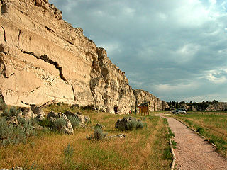
Register Cliff is a sandstone cliff and featured key navigational landmark prominently listed in the 19th century guidebooks about the Oregon Trail, and a place where many emigrants chiseled the names of their families on the soft stones of the cliff — it was one of the key checkpoint landmarks for parties heading west along the Platte River valley west of Fort John, Wyoming which allowed travelers to verify they were on the correct path up to South Pass and not moving into impassable mountain terrains—geographically, it is on the eastern ascent of the Continental Divide leading upward out of the Great Plains in the east of the U.S. state of Wyoming. It is notable as a historic landmark for 'registering' hundreds of emigrants on the Oregon Trail who came to follow custom and inscribed their names on its rocks during the western migrations of the 19th century. An estimated 500,000 emigrants used these trails from 1843 to 1869, with up to one-tenth dying along the way, usually due to disease.

The Overland Trail was a stagecoach and wagon trail in the American West during the 19th century. While portions of the route had been used by explorers and trappers since the 1820s, the Overland Trail was most heavily used in the 1860s as a route alternative to the Oregon, California, and Mormon trails through central Wyoming. The Overland Trail was famously used by the Overland Stage Company owned by Ben Holladay to run mail and passengers to Salt Lake City, Utah, via stagecoaches in the early 1860s. Starting from Atchison, Kansas, the trail descended into Colorado before looping back up to southern Wyoming and rejoining the Oregon Trail at Fort Bridger. The stage line operated until 1869 when the completion of the First transcontinental railroad eliminated the need for mail service via stagecoach.

<span class="mw-page-title-main">Fort Halleck (Wyoming)</span> United States historic place

Fort Halleck was a military outpost that existed in the 1860s along the Overland Trail and stage route in what was then the Territory of Idaho, now the U.S. state of Wyoming. The fort was established in 1862 to protect emigrant travelers and stages transporting mail between Kansas and Salt Lake City, Utah, and named for Major General Henry Wager Halleck, commander of the Department of the Missouri and later General-in-chief of the Union armies.

The 11th Ohio Cavalry Regiment, known in vernacular as the 11th Ohio Cavalry, was a cavalry regiment raised in the name of the governor of Ohio from several counties in southwest Ohio, serving in the Union Army during the American Civil War. The regiment was stationed in the Dakota and Idaho territories on the American frontier to protect travelers and settlers from raids by American Indians.

In the history of the American frontier, pioneers built overland trails throughout the 19th century, especially between 1829 and 1870, as an alternative to sea and railroad transport. These immigrants began to settle much of North America west of the Great Plains as part of the mass overland migrations of the mid-19th century. Settlers emigrating from the eastern United States did so with various motives, among them religious persecution and economic incentives, to move from their homes to destinations further west via routes such as the Oregon, California, and Mormon Trails. After the end of the Mexican–American War in 1849, vast new American conquests again encouraged mass immigration. Legislation like the Donation Land Claim Act and significant events like the California Gold Rush further encouraged settlers to travel overland to the west.

<span class="mw-page-title-main">Route of the Oregon Trail</span>

The historic 2,170-mile (3,490 km) Oregon Trail connected various towns along the Missouri River to Oregon's Willamette Valley. It was used during the 19th century by Great Plains pioneers who were seeking fertile land in the West and North.

<span class="mw-page-title-main">South Platte Trail</span>

South Platte Trail was a historic trail that followed the southern side of South Platte River from Fort Kearny in Nebraska to Denver, Colorado. Plains Indians, such as the Cheyenne and the Arapaho, hunted in the lands around the South Platte River. They also traded at trading posts along the route, as did white travelers. Travelers included trappers, traders, explorers, the military, and those following the gold rush. The trail was also used by the Pony Express.

References

  1. 1 2 Tami Canaday (September 15, 1983). "National Register of Historic Places Inventory—Nomination Form: Fort Laramie National Historic Site" (PDF). National Park Service . Retrieved 2015-04-06. Two photos (1976) and 50 photos (1983)
  2. "National Register Information System". National Register of Historic Places . National Park Service. July 9, 2010.
  3. Griske, Michael, ed. (2005). The Diaries of John Hunton. Heritage Books. pp. 54–55. ISBN   0-7884-3804-2.
  4. L. G. Flannery (1928), A Short History of Old Fort Laramie, incorporated in The Diaries of John Hunton, Made to Last, Written to Last, Sagas of the Western Frontier, edited by Michael Griske (2005), Maryland: Heritage Books
  5. 1 2 Vestal, Stanley (1970). Jim Bridger: Mountain Man. Lincoln: University of Nebraska Press. pp. 110–111. ISBN   978-0803257207.
  6. Russell, Osborne (2001). Haines, Aubrey (ed.). Journal of a Trapper; In the Rocky Mountains between 1834 and 1843. Santa Barbara: The Narrative Press. pp. 127–135. ISBN   978-1589760523.
  7. 1 2 Griske, op. cit., p. 55
  8. "Fort John". Wyoming Places Wiki.[ permanent dead link ]
  9. Unruh, John (1993). The Plains Across: The Overland Emigrants and the Trans-Mississippi West, 1840–60 . University of Illinois Press. ISBN   978-0-252-06360-2.
  10. Hogland, Alison K. Army Architecture in the West: Forts Laramie, Bridger and D.A. Russell, 1849–1912. University of Oklahoma Press. p. 13.
  11. Griske, op. cit., pp. 55, 63
  12. Murray, Robert (1974). Fort Laramie "Visions Of A Grand Past". Fort Collins, Colorado: The Old Army Press.
  13. 1 2 3 4 5 Wayland, Andrew (2018). "Fort Laramie: A Historic Guide to the West Historic Buildings Guide". ProQuest: 29–38 – via ProQuest.
  14. Hoagland, Alison (1998). ""The Invariable Model": Standardization and Military Architecture in Wyoming, 1860-1890". Journal of the Society of Architectural Historians. 57 (3): 298–315 – via JSTOR.
  15. Griske, op. cit., pp. 56, 57