
Columbiana County is a county located in the U.S. state of Ohio. As of the 2020 census, the population was 101,877. The county seat is Lisbon and its largest city is Salem. The county name is derived from that of 15th-century Italian explorer Christopher Columbus.

Kimball Township is a civil township of St. Clair County in the U.S. state of Michigan. As of the 2010 census, the township population was 9,358.

Calcutta is an unincorporated community and census-designated place in southeastern Columbiana County, Ohio, United States. The population was 3,941 at the 2020 census. Historically a rural town, Calcutta grew as businesses from neighboring East Liverpool moved into larger shopping centers clustered around Ohio State Route 170.
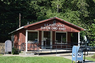
Elkton is an unincorporated community located in central Elkrun Township, Columbiana County, Ohio, United States. It lies along State Route 154 at the confluence of Elk Run and the Little Beaver Creek and has the ZIP code 44415. It is home to the Federal Correctional Institution, Elkton, a male low-security federal prison. Additionally, Elkton is home to one of the shortest covered bridges in the United States, the Church Hill Road Covered Bridge.

Newport is an unincorporated community in Monroe County in the U.S. state of Michigan. The community is located within Berlin Charter Township. As an unincorporated community, Newport has no legally defined boundaries or population statistics of its own but does have its own post office with the 48166 ZIP Code.

Little Beaver Creek is a wild and scenic area in Ohio. The Little Beaver Creek watershed is located primarily in Columbiana County in eastern Ohio, and in portions of Carroll County, Mahoning County, and western Pennsylvania, draining approximately 605 mi² (1,567 km²), of which 503 mi² (1,303 km²) are in Ohio. The watershed in total size covers an area of approximately 510 square miles, with about 80% of this being situated in Ohio. The great majority of land within the watershed is privately owned. Within the watershed are roughly 808 miles of linear streams.

Homeworth is an unincorporated community and census-designated place in southwestern Knox Township, Columbiana County, Ohio, United States. The population was 492 as of the 2020 census. It is part of the Salem micropolitan area, about 16.5 miles (26.6 km) east of Canton, and has a post office with the ZIP code 44634.
St. Clair Township is one of the eighteen townships of Columbiana County, Ohio, United States. As of the 2020 census the population was 7,804.

Liverpool Township is one of the eighteen townships of Columbiana County, Ohio, United States. As of the 2020 census the population was 3,862.

Middleton Township is one of the eighteen townships of Columbiana County, Ohio, United States. The 2020 census reported 3,359 people living in the township.

West Point is an unincorporated community in northern Madison Township, Columbiana County, Ohio, United States. A former coal town, it lies along U.S. Route 30 at its intersection with State Routes 45 and 518, it has the ZIP code 44492. It is part of the Salem micropolitan area.
Negley is an unincorporated community and census-designated place in Middleton Township, Columbiana County, Ohio, United States. The population was 274 at the 2020 census. It is part of the Salem micropolitan area, 22 miles (35 km) south of Youngstown.
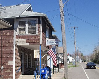
Kensington is an unincorporated community in southwestern Hanover Township, Columbiana County, Ohio, United States. Lying along U.S. Route 30 at its intersection with Ohio State Routes 9 and 644, it has a post office with the ZIP code 44427. Kensington is a part of the Salem micropolitan area, 23 miles (37 km) miles east of Canton and 30 miles (48 km) southwest of Youngstown.

Cassella is an unincorporated community in Marion Township, Mercer County, Ohio, United States. Located at 40°24′22″N84°33′8″W, it lies at an elevation of 955 feet (291 m). Situated at the intersection of State Route 119 and Cassella-Montezuma Road in western Marion Township, it lies in the headwaters of Beaver Creek to the south of the city of Celina, the county seat of Mercer County. Other nearby communities include Maria Stein, 3 miles (4.8 km) to the east, Carthagena, 2 miles (3.2 km) to the north, and St. Henry, 4 miles (6.4 km) to the west.

Clarkson is an unincorporated community in southwestern Middleton Township, Columbiana County, Ohio, United States, clustered around the intersection of Clarkson and Sprucevale roads. For most of the 19th century, until the founding of Negley and Rogers, Clarkson was the most prominent settlement in Middleton Township.

Gaston's Mill-Lock No. 36, Sandy and Beaver Canal District, is a historic district listed in the National Register of Historic Places. The district is located within Beaver Creek State Park, approximately 1 mile south of Clarkson, Ohio. Gaston's Mill was constructed in 1837 and was powered by Little Beaver Creek. Lock 36 was one of 90 locks on the Sandy and Beaver Canal. Construction of this canal began in 1834 but was not completed until 1848.
Williamsport is an unincorporated community in northwestern Madison Township, Columbiana County, Ohio, United States.
Dungannon is an unincorporated community in Hanover Township, Columbiana County, Ohio, United States.
Valley is an unincorporated community in Butler Township, Columbiana County, Ohio, United States. It lies about 2.5 miles (4.0 km) south of Damascus and 6 miles (9.7 km) southwest of Salem.

Salem Heights is an unincorporated community and census-designated place (CDP) in Columbiana County, Ohio, United States. It was first listed as a CDP prior to the 2020 census, in which its population was 336. Salem Heights sits on the 1,275-foot (389 m) Blackburn Hill, separated from the city of Salem by the valley of the Middle Fork of the Little Beaver Creek. It is part of the Salem micropolitan area.


