Related Research Articles

Greenbush Township is a civil township of Clinton County in the U.S. state of Michigan. The population was 2,199 at the 2010 census.

North is a town in Orangeburg County, South Carolina, United States. The population was 696 at the 2020 census.

Cape Fear is a prominent headland jutting into the Atlantic Ocean from Bald Head Island on the coast of North Carolina in the southeastern United States. It is largely formed of barrier beaches and the silty outwash of the Cape Fear River as it drains the southeast coast of North Carolina through an estuary south of Wilmington. Cape Fear is formed by the intersection of two sweeping arcs of shifting, low-lying beach, the result of longshore currents which also form the treacherous, shifting Frying Pan Shoals, part of the Graveyard of the Atlantic.

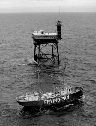
The Frying Pan Shoals are a shifting area of shoals off Cape Fear in North Carolina, United States. Formed by silt from the Cape Fear River, the shoals are over 28 miles long and resemble a frying pan in shape. They provide excellent fishing.

Lizartza is a town located in the province of Gipuzkoa, in the autonomous community of Basque Country, in the North of Spain.
Blounts Creek is a small unincorporated rural community in Beaufort County, North Carolina, United States, situated near a creek with the same name. The ZIP Code for Blounts Creek is 27814.
Sundown is a small community in southeastern Manitoba. It is located in the Rural Municipality of Stuartburn on PR 201, halfway between the communities of Vita and Piney.
Jerry and Pleasant View are two adjacent unincorporated communities in Tyrrell County, North Carolina, United States; Jerry lies southeast of Pleasant View. Both communities lie at an elevation of 3 feet. Jerry is located at 35°52′56″N76°13′37″W, while Pleasant View is located at 35°53′22″N76°13′58″W.
Broadfording is an unincorporated community in Washington County, Maryland, United States.
Last Chance is an unincorporated community in Hyde County, North Carolina, United States.
USCGC Cape Upright was United States Coast Guard steel-hulled patrol boat of the 95-Foot or Cape class.
Indira Col West is a mountain pass at 5,988 metres (19,646 ft)) altitude on the Indira Ridge of Siachen Muztagh in Karakoram Range. It is on the border between Indian-controlled Siachen Glacier and the Chinese-controlled Trans-Karakoram Tract, close to the tripoint of India, Pakistan, and China. The India-Pakistan Actual Ground Position Line (AGPL) in the Siachen area ends near the pass. It is possible to ascend the pass from both the north and south sides controlled by China and India respectively.
Morrisville is an unincorporated community located in Clinton County, Ohio, United States.
Gaysport is an unincorporated community in Muskingum County, in the U.S. state of Ohio.
Vans Valley is an unincorporated community in Delaware County, in the U.S. state of Ohio.
Lakeview is an unincorporated community in Todd County, in the U.S. state of South Dakota.
Comobabi is both a census-designated place (CDP) and a populated place in Pima County, Arizona, United States. The population was 8 at the 2010 census. It is located within the Tohono O'odham Indian Reservation.
Heagy is an unincorporated community in Stoddard County, in the U.S. state of Missouri.

Anamur Lighthouse is a lighthouse in Anamur ilçe (district) of Mersin Province, Turkey.
References
35°48′10″N76°06′13″W / 35.80278°N 76.10361°W
