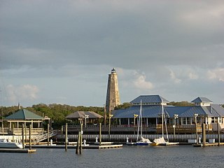
Bald Head Island, historically Smith Island, is a village located on the east side of the Cape Fear River in Brunswick County, North Carolina, United States. Compared to the nearby city of Wilmington to the north, the village of Bald Head Island is small and somewhat remote. It is accessible by ferry from the nearby town of Southport and by four-wheel drive vehicle along the beach strand from Fort Fisher to the north. Only government officials are allowed to drive the beach strand route. There are few cars on the island; instead, residents drive modified electric golf carts. Bald Head Island is nationally recognized for its sea turtle nesting activity.

Cape Hatteras is a cape located at a pronounced bend in Hatteras Island, one of the barrier islands of North Carolina.

Cape Fear is a prominent headland jutting into the Atlantic Ocean from Bald Head Island on the coast of North Carolina in the southeastern United States. It is largely formed of barrier beaches and the silty outwash of the Cape Fear River as it drains the southeast coast of North Carolina through an estuary south of Wilmington. Cape Fear is formed by the intersection of two sweeping arcs of shifting, low-lying beach, the result of longshore currents which also form the treacherous, shifting Frying Pan Shoals, part of the Graveyard of the Atlantic.

Cape Hatteras Light is a lighthouse located on Hatteras Island in the Outer Banks in the town of Buxton, North Carolina and is part of the Cape Hatteras National Seashore. The lighthouse's semi-unique pattern makes it easy to recognize and famous. It is often ranked high on lists of most beautiful, and famous lighthouses in the US.
The Diamond Shoals are an infamous, always-shifting cluster of shallow, underwater sandbars that extend eight miles (13 km) out from Cape Hatteras, North Carolina, United States. Hidden beneath the waves and constantly changing in both form and depth, the shoals are believed to be responsible for up to 600 shipwrecks along the Cape Hatteras shoreline, an area commonly known as the "Graveyard of the Atlantic".
Cape Bojador is a headland on the west coast of Western Sahara, at 26° 07' 37"N, 14° 29' 57"W, as well as the name of the large nearby town with a population of 42,651. The name of the surrounding province also derives its name from the cape.
Oak Island is located on the Atlantic Ocean coast in Brunswick County, North Carolina near the South Carolina border. A barrier island, it contains the towns of Oak Island and Caswell Beach, Fort Caswell and the Oak Island Coast Guard Station which is co-located with the Oak Island Lighthouse. Almost 13 miles long, the island averages about one mile wide. Approximately 7000 people live on it year-round, a number which can balloon to over 40,000 during the summer
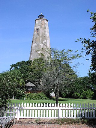
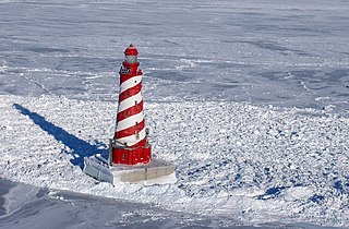
Bald Head Lighthouse, known as Old Baldy, is the oldest lighthouse still standing in North Carolina. It is the second of three lighthouses that have been built on Bald Head Island since the 18th century to help guide ships past the dangerous shoals at the mouth of the Cape Fear river.
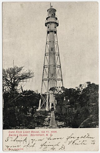
Cape Fear Lighthouse was a coastal beacon built in 1903, replacing the Bald Head Lighthouse as the main navigation aid for Cape Fear and the Frying Pan Shoals off the coast of the U.S. state of North Carolina. It stood near the cape on Bald Head Island. It was a steel octagonal pyramidal skeleton frame lighthouse, as opposed to the conical brick lighthouses usually associated with the state. It was painted red and white horizontal stripes: three white and two red and housed a first-order Fresnel lens produced by the Henry-LePaute Company in France.
Graveyard of the Atlantic is a nickname for the treacherous waters and area of numerous shipwrecks off the Outer Banks of North Carolina, United States, which are due to the coast's shifting sands and inlets. To a lesser degree, this nickname has also been applied to Sable Island off of Nova Scotia, Canada, as well as the waters off Cape Cod, Massachusetts, United States.

Billingsgate Island, also sometimes known as Bellingsgate Island, was an island off Cape Cod in Massachusetts in the United States. Originally settled as a fishing and whaling community as part of the town of Eastham, Massachusetts, Billingsgate Island was for a long time the site of a lighthouse used as a navigational aid in Cape Cod Bay. Local historians sometimes call it the Atlantis of Cape Cod.
Pedro Bank is a large bank of sand and coral, partially covered with seagrass, about 80 km south and southwest of Jamaica, rising steeply from a seabed of 800 metres depth. It slopes gently from the Pedro Cays to the west and north with depths from 13 to 30 metres. The total area of the bank within the 100-metre (328-foot) isobath measures 8,040 square kilometres. The area of a depth to 40 metres is triangular, 70 kilometres long east-west, and 43 kilometres wide. 2,400 square kilometres are less than 20 metres deep. With its islets, cays and rocks, a total land area of 270,000 m2 (2,906,256 sq ft), it is the location of one of the two offshore island groups of Jamaica, the other one being the Morant Cays. The bank is centered at 17°06′N78°20′W.

The 1982 Florida subtropical storm, officially known as Subtropical Storm One, was the only subtropical cyclone of the exceptionally inactive 1982 Atlantic hurricane season. The storm originated from two different systems around the Gulf of Mexico and Caribbean on June 16. The systems merged into trough while a circulation began to form off the coast of Florida on June 18. The depression made landfall in Florida and strengthened into a storm over land. The storm entered the Atlantic Ocean and headed to the northeast, becoming extratropical on June 20 near Newfoundland. The storm was the only system of 1982 to affect the eastern half of the United States, and it caused three fatalities and caused $10 million in damage.
The White Shoal Light is a lighthouse located 20 miles (32 km) west of the Mackinac Bridge in Lake Michigan. It is an active aid to navigation. It is also the tallest lighthouse on the Great Lakes.
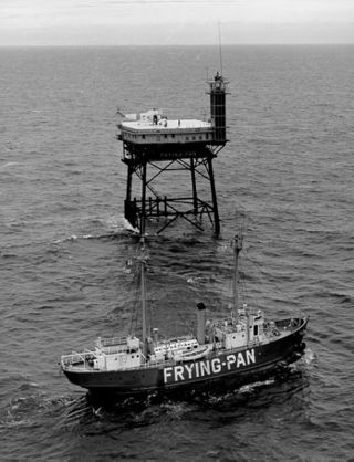
Frying Pan (LV-115) is a lightvessel moored at Pier 66a in the Chelsea neighborhood of Manhattan in New York City. It served at Frying Pan Shoals, off Cape Fear in North Carolina, for over 30 years.
Frying Pan Shoals Light Station is a decommissioned Coast Guard lighthouse located near the end of the Frying Pan Shoals 32 miles (51 km) SE of Bald Head Island, North Carolina. The Frying Pan Tower™ rises 135' above the Atlantic Ocean is being restored by volunteers through FPTower Inc., a 501(c)3 nonprofit whose mission is to help provide safety to mariners and the local sea life as well as providing an on-site facility for environmental research, and to live stream cameras of above and below the ocean. Several universities and governmental agencies have used the tower's unique location to perform vital research over the last decade as it is being restored.

On 27 March 2009, at least one boat carrying migrants from Libya to Italy capsized. The boat is believed to have been carrying 250 migrants from Egypt, Tunisia, Palestine and Nigeria. A rescue attempt involving the Italian and Libyan navies rescued 21 survivors from the boat and retrieved 21 bodies. A further 77 bodies subsequently washed up on the shores of Libya before rescue efforts were called off. Two other boats also went missing between Libya and Italy, carrying around 250 more people between them. A fourth boat, carrying 350 people, was rescued by an Italian merchant ship on 29 March in the same area of sea.
USCGC Cape Upright was United States Coast Guard steel-hulled patrol boat of the 95-Foot or Cape class.

The Ephraim Williams was a sailing ship wrecked off the coast of Hatteras Island, North Carolina, during a late December storm, late in 1884. The rescue of the barkentine's crew by Benjamin B. Dailey and his six oarsmen of the United States Lifesaving Service was considered particularly heroic, and the rescue is celebrated to the present day.

Gracie was a 19th-century Boston pilot boat built in 1869 at the Edward A. Costigan shipyard in Charlestown, Massachusetts. The schooner was used by Boston pilots and was sold to North Carolina pilots in 1881.
