Furman, South Carolina

Last updated

Furman, South Carolina
SCMap-doton-Furman.PNG
Location of Furman, South Carolina
Coordinates: 32°40′52″N81°11′16″W / 32.68111°N 81.18778°W / 32.68111; -81.18778
Country United States
State South Carolina
County Hampton
Government
  TypeCouncil
  MayorFrancenia Ellis
Area
[1]
  Total3.12 sq mi (8.07 km2)
  Land3.12 sq mi (8.07 km2)
  Water0.00 sq mi (0.00 km2)
Elevation
115 ft (35 m)
Population
 (2020) [2]
  Total224
  Density71.84/sq mi (27.74/km2)
Time zone UTC-5 (Eastern (EST))
  Summer (DST) UTC-4 (EDT)
ZIP code
29921
Area code(s) 803 and 839
FIPS code 45-27835 [3]
GNIS feature ID1247850 [4]

Furman is a town in Hampton County, South Carolina, United States. The population was 224 at the 2020 census, [5] down from 239 at the 2010 census. It is not to be confused with Furman University, which is in Greenville, South Carolina.

Contents

Geography

Furman is located in southwestern Hampton County at 32°40′52″N81°11′16″W / 32.68111°N 81.18778°W / 32.68111; -81.18778 (32.681247, -81.187705). [6] U.S. Route 601 (Savannah Highway) passes through the town center, leading north 14 miles (23 km) to Hampton, the county seat, and south 9 miles (14 km) to its terminus at U.S. Route 321. Hardeeville is 28 miles (45 km) south of Furman, and Savannah, Georgia, is 45 miles (72 km) to the south.

According to the United States Census Bureau, Furman has a total area of 3.1 square miles (8.1 km2), all land. [6]

Demographics

Historical population
CensusPop.Note
1920 296
1930 270−8.8%
1940 38040.7%
1950 293−22.9%
1960 244−16.7%
1970 239−2.0%
1980 34845.6%
1990 260−25.3%
2000 28610.0%
2010 239−16.4%
2020 224−6.3%
2021 (est.)232 [7] 3.6%
U.S. Decennial Census [8] [2]

As of the census [3] of 2000, there were 286 people, 108 households, and 80 families residing in the town. The population density was 91.8 people per square mile (35.4 people/km2). There were 126 housing units at an average density of 40.4 per square mile (15.6/km2). The racial makeup of the town was 27.62% White and 72.38% African American.

There were 108 households, out of which 38.0% had children under the age of 18 living with them, 50.0% were married couples living together, 18.5% had a female householder with no husband present, and 25.9% were non-families. 23.1% of all households were made up of individuals, and 6.5% had someone living alone who was 65 years of age or older. The average household size was 2.65 and the average family size was 3.11.

In the town, the population was spread out, with 29.7% under the age of 18, 9.1% from 18 to 24, 25.2% from 25 to 44, 21.3% from 45 to 64, and 14.7% who were 65 years of age or older. The median age was 35 years. For every 100 females, there were 90.7 males. For every 100 females age 18 and over, there were 91.4 males.

The median income for a household in the town was $23,125, and the median income for a family was $27,750. Males had a median income of $25,795 versus $17,292 for females. The per capita income for the town was $12,227. About 19.0% of families and 30.7% of the population were below the poverty line, including 44.4% of those under the age of eighteen and 17.5% of those 65 or over.

Southern Railway in Furman

From 1899 until the 1980s, the Southern Railway operated a line through Furman and nearby Allendale, Tarboro, and Lena. Called the "Southern Columbia to Savannah Route", the rail also ran through Barnwell and Blackville to the north. Its primary purpose was to increase north–south passenger and freight traffic by feeding into the Atlantic Coast Line at Hardeeville for passage south to Florida or north to Charleston and other points. The rail line was built to compete with another north–south rail line operated nearby by the Seaboard Air Line (also called the Florida Central & Peninsular, Seaboard Coast Line, and presently CSX) which ran a different course through Denmark, Fairfax, Estill, and Garnett (parallel to US 321) and then into Georgia. Between 1963 and 1970, Southern abandoned its tracks between Furman and Hardeeville, leaving Furman as the ending station from Columbia. In the early 1980s, Southern abandoned its tracks south of Blackville, ending its rail service to Barnwell, Allendale, and Furman. [9] However, by the 1970s, any rail service to Furman would have been a rare event. [10]

Related Research Articles

<span class="mw-page-title-main">Jasper County, South Carolina</span> County in South Carolina, United States

Jasper County is the southernmost county in the U.S. state of South Carolina. As of the 2020 census, the population was 28,791. Its county seat is Ridgeland and its largest community is Hardeeville. The county was formed in 1912 from portions of Hampton County and Beaufort County.

<span class="mw-page-title-main">Hampton County, South Carolina</span> County in South Carolina, United States

Hampton County is a rural county located in the U.S. state of South Carolina. As of the 2020 census, the population was 18,561. Its county seat is Hampton. It was named for Confederate Civil War general Wade Hampton, who in the late 1870s, with the ending of Reconstruction, was elected as governor of South Carolina.

<span class="mw-page-title-main">Barnwell County, South Carolina</span> County in South Carolina, United States

Barnwell County is a county in the U.S. state of South Carolina. As of the 2020 census, its population was 20,589. It is located in the Central Savannah River Area. Its county seat is Barnwell.

<span class="mw-page-title-main">Allendale County, South Carolina</span> County in South Carolina, United States

Allendale County is a county located in the U.S. state of South Carolina. As of the 2020 census, the population was 8,039, making it the least populous county in South Carolina. Its county seat is Allendale.

<span class="mw-page-title-main">New Ellenton, South Carolina</span> City in South Carolina

New Ellenton is a city in Aiken County, South Carolina, United States. The population was 2,210 at the 2020 census. It is part of the Augusta, Georgia metropolitan area.

<span class="mw-page-title-main">Allendale, South Carolina</span> Town in South Carolina, United States

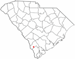
Allendale is a town in and the county seat of Allendale County, South Carolina, United States. The population was 3,482 at the 2010 census, a decline from 4,052 in 2000.

<span class="mw-page-title-main">Fairfax, South Carolina</span> Town in South Carolina, United States

Fairfax is a town in Allendale and Hampton counties, South Carolina, United States. The population was 2,025 at the 2010 census, a decline of over one-third of its population of 3,206 from 2000.

<span class="mw-page-title-main">Ehrhardt, South Carolina</span> Town in South Carolina, United States

Ehrhardt is a town in Bamberg County, South Carolina, United States. As of the 2010 census, the town population was 545.

<span class="mw-page-title-main">Barnwell, South Carolina</span> City in South Carolina, United States

Barnwell is a city in and county seat of Barnwell County, South Carolina, United States, located along U.S. Route 278. The population was 4,750 at the 2010 census.

<span class="mw-page-title-main">Blackville, South Carolina</span> Town in South Carolina, United States

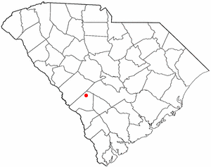
Blackville is a small town in Barnwell County, South Carolina, United States. The population was 2,406 at the 2010 census.

<span class="mw-page-title-main">Elko, South Carolina</span> Town in South Carolina, United States

Elko is a town in Barnwell County, South Carolina, United States. According to the 2010 census the population was 193.

<span class="mw-page-title-main">Hilda, South Carolina</span> Town in South Carolina, United States

Hilda is a town in Barnwell County, South Carolina, United States. The population was 447 at the 2010 census..

<span class="mw-page-title-main">Kline, South Carolina</span> Town in South Carolina, United States

Kline is a town in Barnwell County, South Carolina, United States. The population was 197 at the 2010 census.

<span class="mw-page-title-main">Snelling, South Carolina</span> Town in South Carolina, United States

Snelling is a town in Barnwell County, South Carolina, United States. The population was 274 at the 2010 census.

<span class="mw-page-title-main">Williston, South Carolina</span> Town in South Carolina, United States

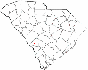
Williston is a town in Barnwell County, South Carolina, United States. The population was 3,139 at the 2010 census.

<span class="mw-page-title-main">Brunson, South Carolina</span> Town in South Carolina, United States

Brunson is a town in Hampton County, South Carolina, United States. The population was 554 at the 2010 census.

<span class="mw-page-title-main">Hardeeville, South Carolina</span> City in South Carolina, United States

Hardeeville is a city in Jasper and Beaufort counties in the U.S. state of South Carolina. The population was 7,473 as of the 2020 census, an increase of over 150% since 2010. Hardeeville is included within the Hilton Head Island–Bluffton metropolitan area.

<span class="mw-page-title-main">Ridgeland, South Carolina</span> Town in South Carolina, United States

Ridgeland is a town in Jasper and Beaufort counties, South Carolina, United States. The population was 3,749 at the 2020 census, a 7.1% decrease from 2010. It has been the county seat of Jasper County since the county's formation in 1912. As defined by the U.S. Census Bureau, Ridgeland is included within the Hilton Head Island–Bluffton metropolitan area.

<span class="mw-page-title-main">Pamplin City, Virginia</span> Town in Virginia, United States

Pamplin City is a town in Appomattox and Prince Edward counties in the U.S. state of Virginia. The population was 138 at the 2020 United States census.

Lena is an unincorporated community in Hampton County, South Carolina, United States, just east of Estill.

References

  1. "ArcGIS REST Services Directory". United States Census Bureau. Retrieved October 15, 2022.
  2. 1 2 "Census Population API". United States Census Bureau. Retrieved October 15, 2022.
  3. 1 2 "U.S. Census website". United States Census Bureau . Retrieved January 31, 2008.
  4. "US Board on Geographic Names". United States Geological Survey. October 25, 2007. Retrieved January 31, 2008.
  5. "Furman town, South Carolina Demographics and Housing 2020 Decennial Census".
  6. 1 2 "2021 U.S. Gazetteer Files". United States Census Bureau. Retrieved December 19, 2021.
  7. "Population and Housing Unit Estimates". United States Census Bureau. July 1, 2021. Retrieved July 25, 2022.
  8. "Census of Population and Housing". Census.gov. Retrieved June 4, 2015.
  9. "Abandoned Rails: Edmund to Hardeeville".
  10. "SR Abandonments in Wagener, Perry, and Salley, S.C."