
Cosgrove Hall is an early-18th-century Grade II listed country house in Cosgrove, Northamptonshire. It was built on the site of an earlier house by the Furtho family. It is not open to the public. It may have been built by John Lumley of Northampton. In the nineteenth century, the building belonged to John Christopher Mansel. In May 1945, Queen Geraldine of Albania, the Queen consort to King Zog I of Albania, opened a fête at the hall. The building was destroyed by fire in October 2016.

Potterspury is a populous village and civil parish in West Northamptonshire, England. The nearest main town is Milton Keynes, the centre of which is about 7 miles south-east. At the time of the 2011 census, the parish's population was 1,453 people.
The Honour of Grafton is a contiguous set of manors in the south of Northamptonshire, England up to the county's eastern border with Buckinghamshire. Its dominant legacies are semi-scattered Whittlewood Forest and a William Kent wing of Wakefield Lodge in the body of that woodland.
Newbottle is a civil parish and largely deserted village in West Northamptonshire, about 4 miles (6.4 km) west of the market town of Brackley. It is close to the Oxfordshire county boundary and about 4.5 miles (7.2 km) south-east of the town of Banbury.

Catmore is a civil parish and village in West Berkshire about 5+1⁄2 miles (9 km) southeast of Wantage. Catmore is in the Berkshire Downs and the centre of the village is about 575 feet (175 m) above sea level.
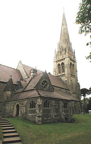
Samuel Sanders Teulon was an English Gothic Revival architect, noted for his use of polychrome brickwork and the complex planning of his buildings.

Bishopstone is a village and civil parish in Wiltshire, England, in the Ebble valley about 5.5 miles (9 km) south-west of Salisbury. The parish is on the county boundary with Hampshire and includes the small village of Croucheston and the hamlet of The Pitts.

Abthorpe is a village and civil parish in the valley of the River Tove in West Northamptonshire, England, about 4 miles (6.4 km) west of Towcester, 2 miles (3.2 km) northwest of Silverstone and approximately midway between London and Birmingham.
The site of Moor End Castle is situated opposite Moor End Farm, along Moor End Road in the civil parish of Yardley Gobion, within the historic county of Northamptonshire.
Benjamin Ferrey FSA FRIBA was an English architect who worked mostly in the Gothic Revival.

Brightwell Baldwin is a village and civil parish in Oxfordshire, about 4+1⁄2 miles (7 km) northeast of Wallingford. It was historically in the Hundred of Ewelme and is now in the District of South Oxfordshire. The 2011 Census recorded the parish's population as 208. The parish is roughly rectangular, about 2+1⁄2 miles (4 km) long north–south and about 1+1⁄4 miles (2 km) wide east–west. In 1848 the parish covered an area of 1,569 acres (635 ha). The B4009 road linking Benson and Watlington forms part of the southern boundary of the parish. The B480 road linking Oxford and Watlington forms a small part of its northern boundary. Rumbolds Lane forms much of its western boundary. For the remainder the parish is bounded largely by field boundaries.
Henry Woodyer (1816–1896) was an English architect, a pupil of William Butterfield and a disciple of A. W. N. Pugin and the Ecclesiologists.

Cornwell is a small village and civil parish about 2.5 miles (4 km) west of Chipping Norton in the West Oxfordshire district of Oxfordshire, near the county border with Gloucestershire. The 2001 Census recorded the parish's population as 66.

Westwell is a small village and civil parish about 2 miles (3 km) southwest of the market town of Burford in Oxfordshire. It is the westernmost village in the county, close to the border with Gloucestershire.

Holton is a village and civil parish in South Oxfordshire about 5.5 miles (9 km) east of Oxford. The parish is bounded to the southeast by the River Thame, to the east and north by the Thame's tributary Holton Brook, to the south by London Road and to the west by field boundaries with the parishes of Forest Hill with Shotover and Stanton St John.

Loddington is a village and civil parish about 3 miles (5 km) west of Kettering, Northamptonshire, England.
Edgcote is a village and former civil parish, now in the parish of Chipping Warden and Edgcote, in the West Northamptonshire district, in the ceremonial county of Northamptonshire, England. It is situated on the River Cherwell. The parish was bounded by the river to the north and by one of its tributaries to the east. The village is about 5.5 miles (9 km) north-east of Banbury in neighbouring Oxfordshire, and the south-western boundary of the parish formed part of the county boundary. In 2001 the parish had a population of 57.

Cottisford is a village and civil parish in Oxfordshire, about 3.5 miles (5.6 km) south of Brackley in neighbouring Northamptonshire. The parish's northern and northwestern boundaries form part of the boundary between the two counties. The parish includes the hamlet of Juniper Hill about 1 mile (1.6 km) northwest of Cottisford. The 2011 Census recorded the parish's population as 216.

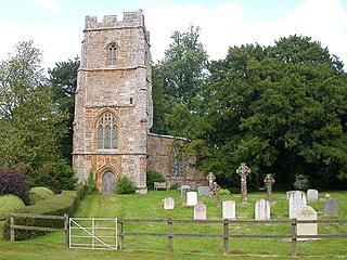
St Bartholomew's Church is a redundant Anglican church in the former village of Furtho, Northamptonshire, England. It is recorded in the National Heritage List for England as a designated Grade II* listed building, and is under the care of the Churches Conservation Trust. A former medieval village, it became deserted following enclosures that began in the early 16th century and were completed by Thomas Furtho in the 1570s. All that remains in the vicinity of the church is a farm and a dovecote.
Edmund Francis Law, usually referred to as 'E. F. Law', FRIBA was an English architect during the 19th century, notable for a large number of projects, particularly restorations, in the counties of Northamptonshire, Leicestershire and Rutland.

