Wolverton

Last updated

Wolverton
Anson Road Wolverton - geograph.org.uk - 173118.jpg
Anson Road, Wolverton
Location map United Kingdom Milton Keynes.png
Red pog.svg
Wolverton
Mapping © OpenStreetMap
Buckinghamshire UK location map.svg
Red pog.svg
Wolverton
Location within Buckinghamshire
Population12,492 (2011, civil parish) [1]
OS grid reference SP816410
Civil parish
Unitary authority
Ceremonial county
Region
Country England
Sovereign state United Kingdom
Post town MILTON KEYNES
Postcode district MK12
Dialling code 01908
Police Thames Valley
Fire Buckinghamshire
Ambulance South Central
UK Parliament
List of places
UK
England
Buckinghamshire
52°03′46″N0°48′37″W / 52.06265°N 0.8102°W / 52.06265; -0.8102

Wolverton is a constituent town of Milton Keynes, England. It is located in the north-west of the city, beside the West Coast Main Line, the Grand Union Canal and the river Great Ouse. It is the administrative seat of Wolverton and Greenleys civil parish.

Contents

It is one of the places in historic Buckinghamshire that went into the foundation of Milton Keynes in 1967.

The village recorded in Domesday is known today as Old Wolverton but, because of peasant clearances in the early 17th century, only field markings remain of the medieval settlement. Modern Wolverton is a new settlement founded in the early 19th century as a railway town, with its centre relocated about 1 km (0.6 mi) to the southeast.

History

Old Wolverton

Holy Trinity church Holy Trinity, Old Wolverton, Bucks - geograph.org.uk - 333043.jpg
Holy Trinity church

The town name is an Old English language word, and means 'Wulfhere's settlement'. [2] It was recorded in the Domesday Book of 1086 as Wluerintone. The original Wolverton was a medieval settlement just north and west of today's town. This site is now known as Old Wolverton, although the medieval village is all but gone. The ridge and furrow pattern of agriculture can still be seen in the nearby fields.

The site of an Anglo-Saxon building has been dated to the 400s at Wolverton Mill, with further buildings coming into use in the 600s and early 700s. [3] An Anglo-Saxon cemetery dated to the 600s was discovered in Wolverton and is the largest discovered in Buckinghamshire containing 83 people. [4]

The Saxon Church of the Holy Trinity (rebuilt in 1819) still sits next to the Norman Motte and Bailey site. [5] Only the earth mound remains of the Norman castle, though the Saxon tower still stands as central to the rebuilt church, clad in the early 19th century 'Anglo-Norman' style. Next door to the church is a house built in 1729 which later became the vicarage; the front door has stonework from the nearby, demolished manor house of the 16th century including the de Longueville family coat of arms, and pieces from the earlier church building. A talbot (dog), another symbol of the family, once graced the side entrance which now marks the boundary between the ground floor of the house and its downstairs toilet.

The manor of Wolverton was held by the de Wolverton family until the mid-fourteenth century. [5] Sir John de Wolverton died in 1349 leaving an infant son, Ralph, who died in 1351, and two daughters. [6] The elder daughter Margaret or Margery, married John le Hunt, Lord Chief Justice of Ireland, and had, in turn, one daughter, Joan le Hunt, who married John Longueville of Billing, Northamptonshire. [7] They had at least one son, John, through whom Wolverton passed by inheritance to the Longueville/Longville family. [5]

Of the historic village itself, only field patterns marking a deserted village remain, along with two village ponds. The desertion of Old Wolverton was due to enclosure of the large strip cultivation fields into small "closes" by the local landlords, the Longville family, who turned arable land over to pasture. By 1654, the family had completely enclosed the parish. With the end of the feudal system, the peasants had lost their land and tillage/grazing rights and were forced to find other work or starve. Thus Old Wolverton was reduced from about thirty peasant families in the mid-16th century to almost none, within the space of a century. [8] [5]

The newer area, built about 1 km (0.62 mi) to the southeast for the railways in the 19th century, assumed the Wolverton name.

Canal village

The Grand Union Canal passes around the northern and eastern edges of the modern town. The canal originally crossed the River Great Ouse by descending 10 metres to the river by nine locks, crossing the river on the level and ascending by eight locks on the other side. This was time-consuming for navigators and subject to disruption in times of flood.

Railway town

Wolverton carriage works Wolverton Carriage Works geograph-2219108.jpg
Wolverton carriage works

In 1838, Wolverton was established as the site of the locomotive repair shop at the midpoint of the London and Birmingham Railway then under construction. [9] In 1846 the L & B became part of the London and North Western Railway, who subsequently[ when? ] decided that locomotives would be built and repaired at Crewe. The last locomotives at Wolverton were built in 1863 and repaired until 1877,[ citation needed ] after which it concentrated on carriages including railway-owned road vehicles. The Works has been the home of the Royal Train fleet. [10] During the Second World War, the Works built parts for Lee–Enfield rifles, bomber plane timber frames, Hawker Typhoon wings, Horsa Gliders, and ambulances.[ citation needed ] Like many older industrial sites, camouflage paint from the period can still be seen on the factory buildings. A pillbox remains opposite the Works Wall. [11]

The railway company built some 200 houses for its workers by 1844 along with schools, a church and a market.[ citation needed ] L&NW also invited George McCorquodale to establish what became a substantial printing works in the town. [12]

Church of St George the Martyr

A new Anglican parish church was built in 1843 to serve the new town centre: like the Church of the Holy Trinity in Old Wolverton, it is a listed building rated a II*. [13]

Historic football ground

The football ground beside the railway works and the station was home to the works team and subsequently to Wolverton Town football club. The stand, built in 1899, is believed to be the oldest covered football stand in the world. It was set to be demolished by September 2006 because its owners wished to redevelop the site for housing and a community park. [14] The development went ahead and a replica stand now sits on the original site to mark the significance of the original construction, painted green as it used to be.

The Wolverton Agora

The Agora Centre was built by the Milton Keynes Development Corporation in 1978 to replace the old market hall on Creed Street. The Agora Centre was known for its shops as well as regular roller-disco events throughout the 1980s.

The building was either loved and hated by residents who either viewed the building as a community asset or as a blight on the town that split the town in two (due to the size of the site). The building was often called a "spaceship" and, when redevelopment plans were released, a "farewell" ceremony was held for the building at the 2019 Wolverton Lantern Festival where the "Agoran" aliens (represented by remote-controlled robots) returned to the Agora and shut the shutters for the final time.

The Agora Centre was demolished in 2022 and is due to be replaced with a development that reinstates the original Victorian road structure and plans to include 86 new properties and 8 shops.

Another Agora Centre is currently open for business in Bletchley's high street, Queensway.

Listed buildings and structures

As of 2021, Wolverton and Greenleys civil parish has two scheduled monuments [15] and two Grade II* listed buildings. [13] There are a further 38 Grade II listed buildings or objects in the parish. [16]

Green spaces

Ouse Valley Park Yes this is Milton Keynes - geograph.org.uk - 446314.jpg
Ouse Valley Park

Wolverton was built with a park (Victoria Park) with a cricket ground, an expanse of allotments for the country people who became railway works employees, and access to the footpaths to the north and south. An extensive section of the River Great Ouse flood plain to the north of Wolverton has been excavated for sand and gravel and the resulting area developed into a nature reserve of flood-tolerant trees, called the Flood Plain Forest. [17]

Secret Garden

In 1999 a group of Wolverton residents clubbed together to persuade Railtrack to sell to the Town Council a piece of derelict land for £1. The council then leased the land to the residents' group for a garden to be created. This piece of land, which sits alongside the Grand Union Canal, has been turned into a small park known locally as the “Secret Garden”, something the residents felt was missing from the largely industrial area. It is maintained by volunteers and hosts outdoor music events in the summer months. It is open to all throughout the year.

Previously the garden was the site of several townhouses built in the early Victorian era for the railways. One of the houses was the residence of the station master for Wolverton. Now the foundations and cellars of two of these houses have been excavated and form a feature in the “Secret Garden”. [18]

Education

The town has a secondary school (the Radcliffe School), two primary schools (Bushfield and Wyvern) and a special school (Slated Row).

Transport

Road

Running through the town (and effectively serving as its high street) is Stratford Road, which runs westwards towards Stony Stratford and eastwards towards Newport Pagnell (and is also known as Newport Road or Wolverton Road on parts of its route). The town is also served by some major grid roads, such as Grafton Street (V6), which runs southwards towards Central Milton Keynes and Bletchley, and Monks Way (H3, A422), which runs eastwards towards Newport Pagnell and Bedford.

For accessing national routes, the A5 (towards Towcester or Dunstable), the A422 westbound (towards Buckingham) and the A508 (towards Northampton) meet about 2 miles (3.2 km) to the west of the town, at a roundabout just north of Old Stratford.

Rail

The town is home to a railway station on the West Coast Main Line, though only local stopping trains call there. Intercity services stop at Milton Keynes Central, about 3 miles (4.8 km) away.

A "toy town" wooden ticket office that stood on the railway bridge, facing out onto Stratford Road, with steps leading down to the platform was actually the third location for a station in Wolverton. The original temporary stop was on the embankment above Wolverton Park, [19] [20] a larger station and refreshment rooms were soon built at a location behind what is now Glyn Square. [21] [22] In the 1880s the main line was re-routed to the east to allow for expansion and the current station site has been in use since. [19] The wooden station stood here for over 100 years, however Milton Keynes Council did not nominate it to be a listed building and British Rail demolished it in 1991, putting a "temporary" unit on platform one instead. [19]

Since then, passengers must use stairways connecting an overhead open walkway to access the other three platforms of the station, making them inaccessible to passengers with mobility impairments. The Council's 'Regeneration Strategy for Wolverton' [23] aimed to build a new station in the original position on the road bridge over the railway. But the new station was built at the platform level, starting in the summer of 2011 and completed in the summer of 2012. [24]

Bus

Wolverton is MK's main northern interchange point for cross-city and rural bus services. The town is served by Arriva bus numbers 4, 5, 6, 7, M5 and Stagecoach Group bus number 83. [25]

Arriva's main bus garage is at Colts Holm Road, Old Wolverton.

MK City Council also operates an on demand bus service known as "MK Connect", which serves the whole MK unitary authority area, including Wolverton. [26]

Civil parish

Wolverton formed a civil parish within the Stratford and Wolverton Rural District from 1894 to 1919, which also contained the parishes of Calverton, Stony Stratford East and Stony Stratford West. The parishes had previously been part of the Potterspury Rural Sanitary District until it was disbanded in 1894. In 1919 these parishes, combined with New Bradwell, became part of the 'Stratford and Wolverton Urban District' (renamed the 'Wolverton Urban District' in 1920). This urban district would remain in existence until 1974 when it became part of the then District of Milton Keynes.

In 1961 the parish of Wolverton had a population of 13,113. [27] On 1 April 1974 the parish was abolished and became an unparished area of the Milton Keynes district. [28]

Today, Wolverton is the larger element of the modern parish of Wolverton and Greenleys.

Sport in Wolverton

The town's sports clubs include

Twin town

ONS urban sub-area (former)

For the 2001 census, the Office for National Statistics used the boundaries of the former Wolverton Urban District Council to designate an Urban Sub-area that it called Wolverton/Stony Stratford. The area covered included Stony Stratford CP, Wolverton and Greenleys CP, New Bradwell CP, Stantonbury CP and part of Great Linford CP. [29] At the 2001 Census, the population of the Sub-area was 60,359. [30] (For the 2011 census, the ONS ceased to use this designation in favour of a much larger 'Built-up Area Sub-Division' it called 'Milton Keynes', despite its excluding Bletchley.)

See also

Related Research Articles

<span class="mw-page-title-main">Milton Keynes</span> City in Buckinghamshire, England

Milton Keynes is a city in Buckinghamshire, England, about 50 miles (80 km) north-west of London. At the 2021 Census, the population of its urban area was 264,349. The River Great Ouse forms the northern boundary of the urban area; a tributary, the River Ouzel, meanders through its linear parks and balancing lakes. Approximately 25% of the urban area is parkland or woodland and includes two Sites of Special Scientific Interest (SSSIs).

<span class="mw-page-title-main">Buckingham</span> Town in Buckinghamshire, England

Buckingham is a market town in north Buckinghamshire, England, close to the borders of Northamptonshire and Oxfordshire, which had a population of 12,890 at the 2011 Census. The town lies approximately 12 miles (19 km) west of Central Milton Keynes, 19 miles (31 km) south-east of Banbury, and 24 miles (39 km) north-east of Oxford.

<span class="mw-page-title-main">City of Milton Keynes</span> Unitary authority area in England

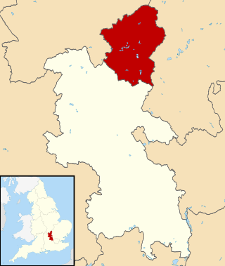
The City of Milton Keynes is a unitary authority area with both borough and city status, in Buckinghamshire. It is the northernmost district of the South East England Region. The borough abuts Bedfordshire, Northamptonshire and the remainder of Buckinghamshire.

<span class="mw-page-title-main">Newport Pagnell</span> Human settlement in England

Newport Pagnell is a town and civil parish in the City of Milton Keynes, Buckinghamshire, England. The Office for National Statistics records Newport Pagnell as part of the Milton Keynes urban area.

<span class="mw-page-title-main">Bletchley</span> Human settlement in England

Bletchley is a constituent town of Milton Keynes, Buckinghamshire, England. It is situated in the south-west of the city, and is split between the civil parishes of Bletchley and Fenny Stratford and West Bletchley. In 2011, the two parishes had a combined population of 37,114.

<span class="mw-page-title-main">Calverton, Buckinghamshire</span> Civil parish in the Borough of Milton Keynes, England

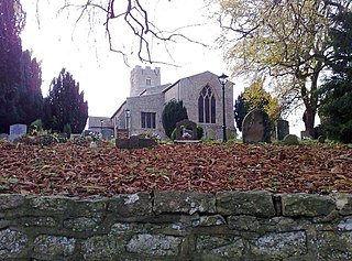
Calverton is a civil parish in the unitary authority area of the City of Milton Keynes, Buckinghamshire, England and just outside the Milton Keynes urban area, situated roughly 1 mile (1.6 km) south of Stony Stratford, and 4 miles (6.4 km) west of Central Milton Keynes. The parish consists of one village, Lower Weald, and two hamlets, Upper Weald and Middle Weald. Lower Weald is the largest of the three settlements, and Manor Farm, the parish church and the former parochial school are within its boundaries.

<span class="mw-page-title-main">Fenny Stratford</span> Human settlement in England

Fenny Stratford is a constituent town of Milton Keynes, Buckinghamshire, England and in the civil parish of Bletchley and Fenny Stratford. Originally an independent town, it was included in the Milton Keynes "designated area" in 1967. From 1895 it formed an urban district with Bletchley, until 1974 when it became part of the (then) District of Milton Keynes. It is located at the southern edge of the city, just east of Bletchley and west of the A5.

<span class="mw-page-title-main">Haversham</span> Human settlement in England

Haversham is a village and former civil parish, now in the parish of Haversham-cum-Little Linford, in the City of Milton Keynes unitary authority area, in Buckinghamshire, England. It is situated to the north of the Milton Keynes urban area, near Wolverton and about 5 miles (8 km) north of Central Milton Keynes.

<span class="mw-page-title-main">Stony Stratford</span> Town and civil parish in Milton Keynes, England

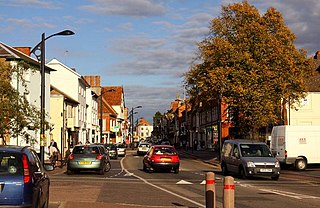
Stony Stratford is a constituent town of Milton Keynes, Buckinghamshire, England. Historically it was a market town on the important route from London to Chester. It is also the name of a civil parish with a town council in the City of Milton Keynes. It is in the north-west corner of the Milton Keynes urban area, bordering Northamptonshire and separated from it by the River Great Ouse.

<span class="mw-page-title-main">History of Buckinghamshire</span>

Although the name Buckinghamshire is Anglo Saxon in origin meaning The district (scire) of Bucca's home the name has only been recorded since about the 12th century. The historic county itself has been in existence since it was a subdivision of the kingdom of Wessex in the 10th century. It was formed out of about 200 communities that could between them fund a castle in Buckingham, to defend against invading Danes.

<span class="mw-page-title-main">Wolverton railway station</span> Railway station in Milton Keynes, England

Wolverton railway station serves Wolverton, a constituent town of Milton Keynes, Buckinghamshire, England. The station is on the West Coast Main Line, about 52 miles (84 km) from Euston, between Milton Keynes Central and Northampton. The station is one of the seven stations serving the Milton Keynes urban area.

Old Stratford is a village and wider civil parish in the south of the English county of Northamptonshire. The population of the civil parish at the 2011 Census was 1,935. The 'Stratford' part of the village name is Anglo-Saxon in origin and means 'ford on a Roman road'. The Roman road in this sense is the Watling Street that runs through the middle of the village.

<span class="mw-page-title-main">New Bradwell</span> Civil parish in Milton Keynes, England

New Bradwell is (mainly) an Edwardian era village, modern district and civil parish in north-west Milton Keynes, Buckinghamshire, England, about 2 miles (3.2 km) north-west of Central Milton Keynes. Together with Wolverton, it was built primarily to house the workers on the Wolverton railway works.

<span class="mw-page-title-main">Central Milton Keynes</span> Civil parish and central business district of Milton Keynes, England

Central Milton Keynes is the central business district of Milton Keynes, Buckinghamshire, England and a civil parish in its own right, with a town council.

Bletchley and Fenny Stratford is a civil parish with a town council, in Milton Keynes, Buckinghamshire, England. It was formed in 2001 from the unparished area of Milton Keynes, and according to the 2011 census had a population of 15,313. Together with West Bletchley, it forms the Bletchley built-up area.

<span class="mw-page-title-main">Wolverton and Greenleys</span> Civil parish in Milton Keynes, England

Wolverton and Greenleys is a civil parish with a town council in Milton Keynes, England. It is north-west of Central Milton Keynes, and according to the 2011 census had a population of 12,492. It includes Wolverton, Old Wolverton, Wolverton Mill, Greenleys and Stonebridge.

<span class="mw-page-title-main">History of Milton Keynes</span> History of the city in England

This history of Milton Keynes details its development from the earliest human settlements, through the plans for a 'new city' for 250,000 people in northern Southeast England, its subsequent urban design and development, to the present day. Milton Keynes, founded in 1967, is the largest settlement and only city in Buckinghamshire. At the 2021 census, the population of its urban area was estimated to have exceeded 256,000.

<span class="mw-page-title-main">MK Metro</span> Bus line based in Milton Keynes, Buckinghamshire

MK Metro was a bus company operating in Milton Keynes from 1997 until 2010.

<span class="mw-page-title-main">Milton Keynes grid road system</span> Top layer of street hierarchy

The Milton Keynes grid road system is a network of predominantly national speed limit, fully landscaped routes that form the top layer of the street hierarchy for both private and public transport in Milton Keynes, Buckinghamshire. The system is unique in the United Kingdom for its innovative use of street hierarchy principles: the grid roads run in between districts rather than through them. This arrangement permits higher speed limits due to the absence of buildings close to the roads – although more recently some have been limited in part to 40 mph (64 km/h). The grid road system also serves an important purpose of discouraging through-traffic from travelling through neighbourhoods and thus reduces traffic noise and pollution in pedestrian areas. Motor traffic is segregated from pedestrian and leisure cycling traffic, which uses the alternative Milton Keynes redway system. Almost all grid junctions are roundabouts, and the absence of traffic lights enables free and efficient movement of traffic.

Wolverton Urban District was a local government district in Buckinghamshire, England, from 1920 to 1974, covering the town of Wolverton and its environs, including the town of Stony Stratford. A district covering this area existed from 1894 to 1974, but was initially a rural district called Stratford and Wolverton Rural District. It was redesignated an urban district in 1919, briefly being called Stratford and Wolverton Urban District before being renamed Wolverton Urban District in 1920.

References

  1. UK Census (2011). "Local Area Report – Wolverton and Greenleys CP (E04012197)". Nomis. Office for National Statistics . Retrieved 1 October 2019.
  2. "Key to English place names: Wolverton". Institute for Name-Studies, University of Nottingham. Archived from the original on 28 February 2022. Retrieved 28 February 2022.
  3. Thorne, A; Chapman, A (2011). "Anglo-Saxon and medieval settlement at the former Post Office Training Establishment, Wolverton Mill, Milton Keynes, Buckinghamshire, Excavations 2004". Museum of London Archaeology. Northamptonshire Archaeology. Retrieved 8 May 2023.
  4. Hancock, A J; Zeepvat, R J. Wulfhere's People: a conversion-period Anglo-Saxon cemetery at Wolverton, Milton Keynes. Monograph Series. Buckinghamshire Archaeological Society. ISBN   9780995717749. reviewed in Hills, Catherine (24 October 2019). "Wulfhere's People: a conversion-period Anglo-Saxon cemetery at Wolverton, Milton Keynes. By A J Hancock and R J Zeepvat. (Buckinghamshire Archaeological Society Monograph Series no. 11. isbn9780995717749. Np.)". The Antiquaries Journal. 99: 451. doi:10.1017/S0003581519000301. ISSN   0003-5815.
  5. 1 2 3 4 William Page, ed. (1927). "Parishes : Wolverton". A History of the County of Buckingham. Victoria History of the Counties of England. Vol. 4. London: Constable & Co. Ltd. p. 505–509.
  6. Post-Mortem Inquisitions; National / Archives; C 135/112/2 (1351/52) & C 135/121/16 (1353/54). The first mentions the death of Ralph & the second Joan, as daughter & heiress of John, son of John
  7. George Baker History of Northamptonshire Vol. II 1826 p.241
  8. Milton Keynes Parks Trust information point on site.
  9. "London & Birmingham Railway Part 1". Rail Album. Retrieved 13 July 2020.
  10. For the Royal Train see this article at the site of the MK Museum
  11. "Corner of Radcliffe Street and Stratford Road". Google Maps. Retrieved 28 February 2022.
  12. "McCorquodale Printing Company, Wolverton" (PDF). Discover Milton Keynes. Retrieved 19 March 2018.
  13. 1 2 Holy Trinity Church, Old Wolverton. (listed building . No. 1125323);
    Church of St George the Martyr (listed building . No. 1125328);
    Stephenson's railway bridge over the Grand Union (listed building . No. 1246107)
  14. "Save Our Stand?". BBC News . 20 January 2006. Retrieved 21 November 2022.
  15. Wolverton castle, deserted village and monastic grange. Scheduled monument . No. 1013660;
    the Iron Trunk Aqueduct (Grand Union over River Ouse). Scheduled monument . No. 1006934
  16. "Search the list". English Heritage.
  17. "Floodplain forest". Milton Keynes Parks Trust . Retrieved 20 February 2022.
  18. Site history   Wolverton Secret Garden Society
  19. 1 2 3 Geoffrey Ealden; Anna McEvoy; Julia Newman; Andra Roach; Peter Smith. "Wolverton: From Aqueduct to Viaduct". Wolverton Society for Arts and Heritage and Milton Keynes Heritage Association. Archived from the original on 20 February 2022. Retrieved 7 December 2007.
  20. Mapley family history – Accessed 7 December 2007
  21. "Wolverton's Second Station". Milton Keynes: Living Archive. Retrieved 6 September 2020.
  22. Ordnance Survey (1885). "Buckinghamshire IX (includes: Castlethorpe; Cosgrove; Old Stratford; Wolverton.)" (Map). OS Six-inch England and Wales, 1842–1952. 1:10,560. National Library of Scotland. Retrieved 6 September 2020.
  23. WOLVERTON REGENERATION STRATEGY 30 MARCH 2004   Milton Keynes Council
  24. "Mayor reveals plaque at Wolverton train station". Milton Keynes Citizen . 28 June 2012.
  25. "Bus and Taxi, Bus Timetables, Maps and Travel Updates". Milton Keynes City Council .
  26. "On-Demand Rideshare in Milton Keynes powered by Via". Via.
  27. "Population statistics Wolverton CP/AP through time". A Vision of Britain through Time . Retrieved 20 March 2024.
  28. "North Bucks Registration District". UKBMD. Retrieved 20 March 2024.
  29. Map of Wolverton/Stony Stratford Urban Sub-area
  30. KS01 Usual resident population: Census 2001, Key Statistics for urban areas, line 1815