California is a U.S. state on the western coast of North America. Covering an area of 163,696 sq mi (423,970 km2), California is geographically diverse. The Sierra Nevada, the fertile farmlands of the Central Valley, and the arid Mojave Desert of the south are some of the major geographic features of this U.S. state. It is home to some of the world's most exceptional trees: the tallest, most massive, and oldest. It is also home to both the highest and lowest points in the 48 contiguous states.
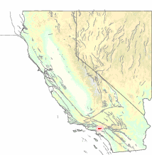
The state is generally divided into Northern and Southern California, although the boundary between the two is not well defined. San Francisco is decidedly a Northern California city and Los Angeles likewise a Southern California one, but areas in between do not often share their confidence in geographic identity. The US Geological Survey defines the geographic center of the state at a point near North Fork, California.

Southern California is a geographic and cultural region that generally comprises California's southernmost counties, and is the second most populous urban agglomeration in the United States. The region is traditionally described as eight counties, based on demographics and economic ties: Imperial, Los Angeles, Orange, Riverside, San Bernardino, San Diego, Santa Barbara, and Ventura. The more extensive 10-county definition, which includes Kern and San Luis Obispo counties, is also used and is based on historical political divisions.

The San Andreas Fault is a continental transform fault that extends roughly 1,200 kilometers (750 mi) through California. It forms the tectonic boundary between the Pacific Plate and the North American Plate, and its motion is right-lateral strike-slip (horizontal). The fault divides into three segments, each with different characteristics and a different degree of earthquake risk. The slip rate along the fault ranges from 20 to 35 mm /yr.

Owens Valley is the now-arid valley of the Owens River in eastern California in the United States, to the east of the Sierra Nevada and west of the White Mountains and Inyo Mountains on the west edge of the Great Basin. The mountain peaks on either side reach above 14,000 feet (4,300 m) in elevation, while the floor of the Owens Valley is about 4,000 feet (1,200 m), making the valley one of the deepest in the United States. The Sierra Nevada casts the valley in a rain shadow, which makes Owens Valley "the Land of Little Rain." The bed of Owens Lake, now a predominantly dry endorheic alkali flat, sits on the southern end of the valley.
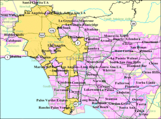
The Los Angeles metropolitan area, also known as Metropolitan Los Angeles or the Southland, is the 30th largest metropolitan area in the world and the second-largest metropolitan area in the United States. It is the 3rd largest city by GDP in the world with a $1 trillion+ economy. It is entirely in the southern portion of the U.S. state of California. The tallest building in the Los Angeles metropolitan area is the Wilshire Grand Center at 1,100 feet in Downtown Los Angeles.

The Salton Sea is a shallow, saline, endorheic rift lake located directly on the San Andreas Fault, predominantly in the U.S. state of California's Imperial and Coachella valleys.

The Las Vegas Valley is a major metropolitan area in the southern part of the U.S. state of Nevada. The state's largest urban agglomeration, it is the heart of the Las Vegas–Paradise-Henderson, NV MSA. The Valley is largely defined by the Las Vegas Valley landform, a 600 sq mi (1,600 km2) basin area surrounded by mountains to the north, south, east and west of the metropolitan area. The Valley is home to the three largest incorporated cities in Nevada: Las Vegas, Henderson and North Las Vegas. Five unincorporated towns governed by the Clark County government are part of the Las Vegas Township and constitute the largest community in the state of Nevada.

The Los Angeles Basin is a sedimentary basin located in southern California, in a region known as the Peninsular Ranges. The basin is also connected to an anomalous group of east-west trending chains of mountains collectively known as the California Transverse Ranges. The present basin is a coastal lowland area, whose floor is marked by elongate low ridges and groups of hills that is located on the edge of the Pacific plate. The Los Angeles Basin, along with the Santa Barbara Channel, the Ventura Basin, the San Fernando Valley, and the San Gabriel Basin, lies within the greater southern California region. On the north, northeast, and east, the lowland basin is bound by the Santa Monica Mountains and Puente, Elysian, Repetto hills. To the southeast, the basin is bordered by the Santa Ana mountains and the San Joaquin Hills. The western boundary of the basin is marked by the Continental Borderland and is part of the onshore portion. The California borderland is characterized by north-west trending offshore ridges and basins. The Los Angeles Basin is notable for its great structural relief and complexity in relation to its geologic youth and small size for its prolific oil production. Yerkes et al. identify 5 major stages of the basin's evolution that begins in the Upper Cretaceous and ends in the Pleistocene. This basin can be classified as an irregular pull-apart basin accompanied by rotational tectonics during the post-early Miocene.

Vasquez Rocks Natural Area Park is a 932-acre (377-hectare) park located in the Sierra Pelona Mountains in northern Los Angeles County, California. It is located in the town of Agua Dulce, between the suburbs of Santa Clarita and Palmdale. The area is also visible from the Antelope Valley Freeway.

The 1857 Fort Tejon earthquake occurred at about 8:20 a.m. on January 9 in central and Southern California. One of the largest recorded earthquakes in the United States, with an estimated moment magnitude of 7.9, it ruptured the southern part of the San Andreas Fault for a length of about 225 miles, between Parkfield and Wrightwood.
The Carrizo Plain (Obispeño: tšɨłkukunɨtš, "Place of the rabbits"; is a large enclosed grassland plain, approximately 50 miles long and up to 15 miles across, in southeastern San Luis Obispo County, California, about 100 miles northwest of Los Angeles. It contains the 246,812-acre Carrizo Plain National Monument, and it is the largest single native grassland remaining in California. It includes Painted Rock in the Carrizo Plain Rock Art Discontiguous District, which is listed on the National Register of Historic Places. In 2012 it was further designated a National Historic Landmark due to its archeological value. The San Andreas Fault cuts across the plain.

The San Bernardino Valley is a valley in Southern California. It lies at the south base of the Transverse Ranges. It is bordered on the north by the eastern San Gabriel Mountains and the San Bernardino Mountains; on the east by the San Jacinto Mountains; and on the south by the Temescal Mountains and Santa Ana Mountains; and on the west by the Pomona Valley. Elevation varies from 180 metres (590 ft) on valley floors near Chino, where it gradually increases to about 420 metres (1,380 ft) near San Bernardino and Redlands. The valley floor houses roughly over 80% of the over 4 million total human population in the Inland Empire region.

The Mendocino Fracture Zone is a fracture zone and transform boundary off the coast of Cape Mendocino in far northern California. It runs westward from a triple junction with the San Andreas Fault and the Cascadia subduction zone to the southern end of the Gorda Ridge. It continues on west of its junction with the Gorda Ridge, as an inactive remnant section which extends for several hundred miles.
The Raymond Fault is a fault across central Los Angeles County and western Ventura County in Southern California.

The Sierra Pelona Mountains, or the Sierra Pelona Ridge, is a mountain range of the Transverse Ranges in Southern California. Located in northwest Los Angeles and southern Kern Counties, the range is bordered on the north by the San Andreas fault and lies within and is surrounded by the Angeles National Forest.
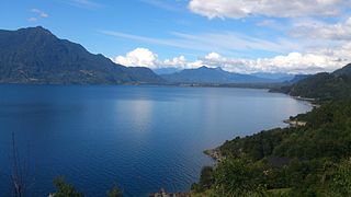
Carrán-Los Venados is a volcanic group of scoria cones, maars and small stratovolcanoes in southern Chile, southeast of Ranco Lake. The highest cone is Los Guindos, which is a small stratovolcano with an elevation of 1,114 metres (3,655 ft). The volcanic group has recorded eruptions from 1955 and 1979. Located south of Maihue Lake and north Puyehue Volcano Carrán-Los Venados group is placed at the intersection of several faults on the thin crust (~30 km) of southern Chile, among them Liquiñe-Ofqui and Futrono Fault.

The Edgar Dam is an earthfill embankment saddle dam without a spillway, located offstream in the South West region of Tasmania, Australia.

Lake Edgar was a natural fault scarp pond on the upper reaches of the Huon River in South West Tasmania.
There are 9 routes assigned to the "N" zone of the California Route Marker Program, which designates county routes in California. The "N" zone includes county highways lying in Los Angeles and Orange counties.