The West Coast is a region of New Zealand on the west coast of the South Island. It is administered by the West Coast Regional Council, and is known co-officially as Te Tai Poutini. It comprises the territorial authorities of Buller District, Grey District and Westland District. The principal towns are Westport, Greymouth and Hokitika. The region, one of the more remote areas of the country, is also the most sparsely populated. With a population of just 32,900 people, the West Coast is the least populous region in New Zealand. The population in the region grew by 0.4% over the year to July 2023.

Alexandra is a town in the Central Otago district of the South Island of New Zealand. It is on the banks of the Clutha River, on State Highway 8, 188 kilometres (117 mi) by road from Dunedin and 33 kilometres (21 mi) south of Cromwell. The nearest towns to Alexandra via state highway 8 are Clyde seven kilometres to the northwest and Roxburgh forty kilometres to the south. State highway 85 also connects Alexandra to Omakau, Lauder, Oturehua, Ranfurly and on to Palmerston on the East Otago coast.

The Clutha River is the second longest river in New Zealand and the longest in the South Island. It flows south-southeast 338 kilometres (210 mi) through Central and South Otago from Lake Wānaka in the Southern Alps to the Pacific Ocean, 75 kilometres (47 mi) south west of Dunedin. It is the highest volume river in New Zealand, and the swiftest, with a catchment of 21,000 square kilometres (8,100 sq mi), discharging a mean flow of 614 cubic metres per second (21,700 cu ft/s). The river is known for its scenery, gold-rush history, and swift turquoise waters. A river conservation group, the Clutha Mata-Au River Parkway Group, is working to establish a regional river parkway, with a trail, along the entire river corridor.

Arrowtown is a historic gold mining town in the Otago region of the South Island of New Zealand. Arrowtown is located on the banks of the Arrow River approximately 7.5 km from State Highway 6. Arrowtown is located 19.5 kilometres to the east of Queenstown. As well as the route via State Highway 6 at Arrow Junction, there is also road access directly to Queenstown via Arthurs Point and a third route via the picturesque Lake Hayes.

Cromwell is a town in Central Otago region of the South Island of New Zealand. Cromwell is located on the shores of Lake Dunstan where the Kawarau river joins Lake Dunstan. Cromwell was established during the Otago gold rush and is now more known as one of the sub regions of the Central Otago wine region. In 2018, the town of Cromwell was home to a population of 5610 people.

Lawrence is a small town in Otago, in New Zealand's South Island. It is located on State Highway 8, the main route from Dunedin to the inland towns of Queenstown and Alexandra. It lies 35 kilometres to the northwest of Milton, 11 kilometres northwest of Waitahuna, and close to the Tuapeka River, a tributary of the Clutha.
The Tuapeka River is a river located in Otago in the South Island of New Zealand. It is a tributary of the Clutha River, which it joins at Tuapeka Mouth between Roxburgh and Balclutha.

Thomas Gabriel Read was a gold prospector and farmer. His discovery of gold in Gabriel's Gully triggered the first major gold rush in New Zealand.

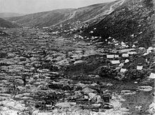
The Otago gold rush was a gold rush that occurred during the 1860s in Central Otago, New Zealand. This was the country's biggest gold strike, and led to a rapid influx of foreign miners to the area – many of them veterans of other hunts for the precious metal in California and Victoria, Australia. The number of miners reached its maximum of 18,000 in February 1864.

Sir George Fenwick was a New Zealand newspaper proprietor and editor. He is best known for his time as manager and editor of the Otago Daily Times, during which time he supported the campaign initiated by Rutherford Waddell against sweat shops.

The villages and then city that lay at the head of Otago Harbour never existed in isolation, but have always been a staging ground between inland Otago and the wider world. While Dunedin's current official city limits extend north to Waikouaiti, inland to Middlemarch and south to the Taieri River mouth, this articles focus is the history of the Dunedin urban area, only mentioning Mosgiel, the Otago Peninsula, Port Chalmers and inland Otago for context.
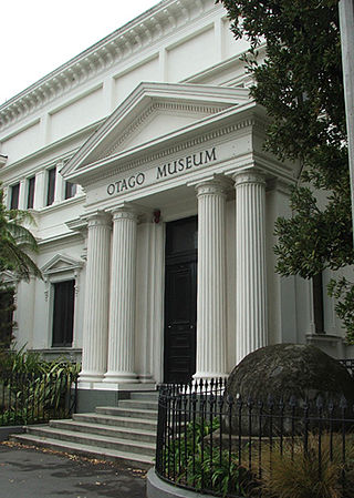
Tūhura Otago Museum, located near the city center of Dunedin, New Zealand, adjacent to the University of Otago campus, is one of the country's largest museums and a prominent attraction in the city. The museum's extensive collections encompass natural science specimens and humanities artifacts from the Otago region and around the world, which are featured in its long-term gallery displays. A notable feature of the museum is its interactive science center, which includes an immersive tropical rainforest butterfly house. In 2022, the museum was officially renamed Tūhura Otago Museum, incorporating the Māori name "Tūhura," meaning "to discover, investigate, and explore."
The following lists events that happened during 1861 in New Zealand.

The Otago Infantry Regiment was a military unit that served within the New Zealand Expeditionary Force (NZEF) in World War I during the Gallipoli Campaign (1915) and on the Western Front (1916–1919). This Regiment and the Otago Mounted Rifles Regiment were composed mostly of men from Otago and Southland. The Otago Infantry Regiment represented the continuation of the Dunedin and Invercargill Militia Battalions formed in 1860.
Horatio Hartley (1826–1903) was an American gold prospector who participated in the Otago gold rush in New Zealand in the 1860s.
Hallie Ruth Buckley is a New Zealand bioarchaeologist and professor at the University of Otago.
Alexander Crow McGeorge was a New Zealand engineer and gold dredging entrepreneur, contributing to the Otago gold rush of the 1890s.
The Lonely Graves Historic Reserve is an old gold mining cemetery in Central Otago, New Zealand. It is in an area which was known as Horseshoe Bend, on the eastern bank of the Clutha/Mata-Au River, about 10 km downstream from the township of Millers Flat. The Reserve is administered by the New Zealand Department of Conservation.
Christopher Reilly was an Irish gold prospector who participated in the Otago gold rush in New Zealand in the 1860s.
Edward Peters, otherwise known as Black Peter, was a farm hand and pioneer gold prospector who first reported finding gold in the Tokomairaro River which would later become part of New Zealand's first workable goldfield: the Tuapeka Goldfield, including Gabriel's Gully.