Raes Junction is a small settlement in New Zealand, located at the intersection of State Highways 8 and 90, in the lower South Island. The highways which meet at the junction are the main routes to the Clutha valley for travellers from Dunedin and Invercargill respectively.

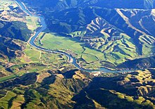
The Clutha River is the second longest river in New Zealand and the longest in the South Island. It flows south-southeast 338 kilometres (210 mi) through Central and South Otago from Lake Wānaka in the Southern Alps to the Pacific Ocean, 75 kilometres (47 mi) south west of Dunedin. It is the highest volume river in New Zealand, and the swiftest, with a catchment of 21,000 square kilometres (8,100 sq mi), discharging a mean flow of 614 cubic metres per second (21,700 cu ft/s). The river is known for its scenery, gold-rush history, and swift turquoise waters. A river conservation group, the Clutha Mata-Au River Parkway Group, is working to establish a regional river parkway, with a trail, along the entire river corridor.

Milton, formerly known as Tokomairiro or Tokomairaro, is a town of over 2,000 people, located on State Highway 1, 50 kilometres to the south of Dunedin in Otago, New Zealand. It lies on the floodplain of the Tokomairaro River, one branch of which loops past the north and south ends of the town. This river gives its name to many local features, notably the town's only secondary school, Tokomairiro High School.

The Manuherikia River is located in Otago in the South Island of New Zealand. It rises in the far north of the Maniototo, with the West Branch draining the eastern side of the St Bathans Range, and the East Branch draining the western flanks of the Hawkdun Range. The river continues southwest through the wide Manuherikia Valley to its confluence with the Clutha River at Alexandra. During the 1860s the Manuherikia was one of the centres of the Central Otago Gold Rush.
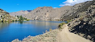
The Cromwell Gorge is a steep gorge cut by the former Clutha River in the Central Otago region of New Zealand's South Island. It winds 19 km (12 mi) between the Dunstan and Cairnmuir Mountains, linking the townships of Cromwell and Clyde. It is one of three substantial river gorges in Central Otago, the others being the Kawarau Gorge to the west of Cromwell, and the Roxburgh Gorge south of Alexandra.
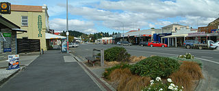
Roxburgh is a small New Zealand town of about 600 people in Central Otago. It is in Teviot Valley on the banks of the Clutha River, 40 kilometres (25 mi) south of Alexandra in the South Island. State Highway 8, which links Central Otago with Dunedin city, passes through the town. Roxburgh is well known for its Summer fruit and "Jimmy's Pies."
Paerau is a small settlement in inland Central Otago in New Zealand's South Island. It is located in the Strath Taieri, the upper valley of the Taieri River, at the foot of the Rock and Pillar Range. "Paerau" is a Māori-language name meaning "one hundred ridges".
The Tapanui Branch was a railway line located near the border of the regions of Southland and Otago, New Zealand. Although the name suggests that it terminated in Tapanui, its furthest terminus was actually in Edievale. Construction of the line began in 1878 with the first section opened in 1880, and it operated until 1978, when it was destroyed by flooding from the Pomahaka River.
Romahapa is a locality in the Catlins region of Otago in New Zealand's South Island. It is located between the towns of Balclutha and Owaka. The last shop closed in 1977.
The Roxburgh Branch was a branch line railway built in the Otago region of New Zealand's South Island that formed part of the country's national rail network. Originally known as the Lawrence Branch, it was one of the longest construction projects in New Zealand railway history, beginning in the 1870s and not finished until 1928. The full line was closed in 1968.
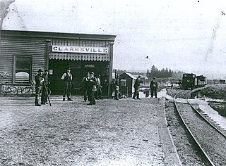
Clarksville is a small township located three kilometres southwest of Milton in the Otago region of the South Island of New Zealand. State Highways 1 and 8 meet in Clarksville. The town was also once the location of a railway junction, where the Roxburgh Branch left the Main South Line. Construction of this branch line began in the 1870s and Clarksville acted as the junction until 1907, when an extension of the branch was built alongside the Main South Line into Milton to improve operations. This led to Milton being the junction until 1960, when the extension was removed and Clarksville regained its status as a junction until the branch was entirely closed in 1968.

Tahora, later also known as Parae, is a locality in the Otago region of New Zealand's South Island, about one kilometre north of Owaka located at the Ōwaka River. Previously on a railway line, Tahora was a request stop. Today, there is little trace of the settlement and only parts of the railway formation remains visible.
Glenpark is a lightly populated rural locality in the Otago region of New Zealand's South Island. It is northwest of Palmerston and is on the banks of the Shag River. To the west is the locality of Stoneburn.
Inch Valley is a lightly populated rural locality in the Otago region of New Zealand's South Island. It is northwest of Palmerston and Glenpark, east of Stoneburn, on the banks of the Shag River. Economic activity around Inch Valley is agricultural.
Finegand is a locality in the South Otago region of New Zealand's South Island.
Otanomomo is a locality in the South Otago region of New Zealand's South Island. It is situated on the banks of the Koau Branch of the Clutha River, roughly six kilometres south of Balclutha. Nearby settlements include Finegand to the north, Paretai, Puerua, and Romahapa to the south, and Waitepeka to the west.

State Highway 8 is one of New Zealand's eight national highways. It forms an anticlockwise loop through the southern scenic regions of the Mackenzie Basin and Central Otago, starting and terminating in junctions with State Highway 1. Distances are measured from north to south.

Kelso is an abandoned small settlement in Otago, New Zealand, located ten kilometres north of Tapanui on the Crookston Burn, close to its junction with the larger Pomahaka River. Its population during the 1960s and 1970s was close to 300, with most of its economy based on sheep farming. A small dairy factory was a focal point in the village's early years.
The Beaumont River is a river in the Central Otago district of New Zealand. It is a tributary of the Clutha River, merging with it just upstream of the small town of Beaumont.
Mount Stuart is a rural locality and settlement in South Otago, New Zealand. It is located between Manuka Creek and Glenore on State Highway 8, approximately halfway between Milton and Waitahuna. It sits close to the upper reaches of the west branch of the Tokomairiro River, just below the confluence with the Manuka Stream.