Clyde, New Zealand

Last updated

Clyde
Town
Clyde New Zealand October 2013 003.JPG
Clyde, Central Otago, New Zealand
Clyde, New Zealand
Coordinates: 45°11′S169°19′E / 45.183°S 169.317°E / -45.183; 169.317
CountryNew Zealand
Region Otago
Territorial authority Central Otago District
WardVincent Ward
CommunityVincent Community
Electorates
Government
  Territorial authority Central Otago District Council
  Regional council Otago Regional Council
   Mayor of Central Otago Tim Cadogan
   Southland MP Joseph Mooney
   Te Tai Tonga MP Tākuta Ferris
Area
[1]
   Urban area 2.08 km2 (0.80 sq mi)
Population
 (June 2023) [2]
   Urban area 1,260
  Density610/km2 (1,600/sq mi)
Time zone UTC+12 (NZST)
  Summer (DST) UTC+13 (NZDT)
Local iwi Ngāi Tahu

Clyde, formerly Dunstan, is a small town in Central Otago, New Zealand with a population of 1,260 in June 2023. [2] It is located on the Clutha River, between Cromwell and Alexandra.

Contents

Clyde grew up around the former settlement of Dunstan during the Central Otago goldrush of the 1860s. The town could once claim to be the most populous in New Zealand during the height of gold fever. The town's post office (and thus the town) was officially renamed from Dunstan to Clyde on 22 May 1865, after Lord Clyde. [3]

St Dunstan's Church a now heritage building designed by the architect Francis William Petre in the early English Gothic revival style was built in Clyde in 1903. [4]

More recently the town has been known for the Clyde Dam, a giant hydroelectric dam at the north end of the town, behind which lies Lake Dunstan. The Clutha River is the swiftest river (per volume) in the southern hemisphere. The river then runs to the Roxburgh Dam before finally meeting the sea at Balclutha.

The town is a popular holiday spot. It lies at the western end of the Otago Central Rail Trail. The Otago Central Branch Railway originally terminated at Cromwell, but this section of the railway was closed in 1980, with the railway to Clyde used to bring materials for the dam project. The rail trail is nowadays often cycled and walked by visitors and locals alike.

The township is home to Dunstan Hospital, serving the surrounding district, including Alexandra and Cromwell. The hospital was rebuilt in 2006 with the original building remaining.

Clyde is fast becoming known as a tourist haven. The location is particularly attractive to those visiting the region's many vineyards and orchards. The regional weather is particularly warm and dry during the summer months due to the rain shadow effect caused by the Southern Alps (given New Zealand's westerly winds).

During the week beginning 22 September, the Clyde/Alexandra district hosts a Blossom Festival. This event celebrates the beginning of spring which brings the blossoming of fruit trees in the area's orchards. Entertainment at the festival includes a parade with floats made by local businesses, fun park rides, and bands.

Demographics

Clyde is described by Statistics New Zealand as a small urban area, and covers 2.08 km2 (0.80 sq mi). [1] It had an estimated population of 1,260 as of June 2023, [5] with a population density of 606 people per km2.

Historical population
YearPop.±% p.a.
2006906    
2013999+1.41%
20181,161+3.05%
Source: [6]
Sunderland Street Sunderland Street, Clyde, Otago, New Zealand.jpg
Sunderland Street
Former Clyde Post Office Former Clyde Post Office,Clyde, Otago, New Zealand 2384.jpg
Former Clyde Post Office
St Dunstan's Church (Catholic) Clyde, Otago St Dunstan's Church (Catholic) Clyde, Otago, New Zealand 2387.jpg
St Dunstan's Church (Catholic) Clyde, Otago

Clyde had a population of 1,161 at the 2018 New Zealand census, an increase of 162 people (16.2%) since the 2013 census, and an increase of 255 people (28.1%) since the 2006 census. There were 528 households, comprising 594 males and 564 females, giving a sex ratio of 1.05 males per female. The median age was 55.6 years (compared with 37.4 years nationally), with 165 people (14.2%) aged under 15 years, 99 (8.5%) aged 15 to 29, 558 (48.1%) aged 30 to 64, and 342 (29.5%) aged 65 or older.

Ethnicities were 93.8% European/Pākehā, 6.2% Māori, 1.8% Pasifika, 2.3% Asian, and 2.1% other ethnicities. People may identify with more than one ethnicity.

The percentage of people born overseas was 11.6, compared with 27.1% nationally.

Although some people chose not to answer the census's question about religious affiliation, 53.2% had no religion, 37.5% were Christian, 0.3% were Buddhist and 1.3% had other religions.

Of those at least 15 years old, 153 (15.4%) people had a bachelor's or higher degree, and 198 (19.9%) people had no formal qualifications. The median income was $31,000, compared with $31,800 nationally. 144 people (14.5%) earned over $70,000 compared to 17.2% nationally. The employment status of those at least 15 was that 477 (47.9%) people were employed full-time, 156 (15.7%) were part-time, and 21 (2.1%) were unemployed. [6]

Education

Clyde School is a co-educational state primary school for Year 1 to 8 students, [7] [8] with a roll of 161 as of February 2024. [9] The school opened in 1863. [7]

The nearest high school is Dunstan High School, which is situated 10 km away in Alexandra. [10]

The nearest university is Otago University 200 km away in Dunedin.

Climate

Climate data for Clyde (1991–2020)
MonthJanFebMarAprMayJunJulAugSepOctNovDecYear
Mean daily maximum °C (°F)23.9
(75.0)
23.8
(74.8)
21.3
(70.3)
17.2
(63.0)
12.9
(55.2)
8.8
(47.8)
8.0
(46.4)
11.7
(53.1)
15.2
(59.4)
17.6
(63.7)
19.8
(67.6)
22.3
(72.1)
16.9
(62.4)
Daily mean °C (°F)17.2
(63.0)
16.8
(62.2)
14.3
(57.7)
10.4
(50.7)
7.2
(45.0)
3.7
(38.7)
2.8
(37.0)
5.5
(41.9)
8.9
(48.0)
11.2
(52.2)
13.3
(55.9)
15.7
(60.3)
10.6
(51.0)
Mean daily minimum °C (°F)10.4
(50.7)
9.8
(49.6)
7.2
(45.0)
3.7
(38.7)
1.5
(34.7)
−1.3
(29.7)
−2.3
(27.9)
−0.6
(30.9)
2.7
(36.9)
4.8
(40.6)
6.7
(44.1)
9.2
(48.6)
4.3
(39.8)
Average rainfall mm (inches)51.0
(2.01)
40.9
(1.61)
32.8
(1.29)
33.5
(1.32)
31.9
(1.26)
32.8
(1.29)
23.8
(0.94)
24.1
(0.95)
25.7
(1.01)
35.7
(1.41)
34.8
(1.37)
49.1
(1.93)
416.1
(16.39)
Source: NIWA (rain 1981–2010) [11]

Notable people

Related Research Articles

<span class="mw-page-title-main">Otago</span> Region of New Zealand

Otago is a region of New Zealand located in the southern half of the South Island administered by the Otago Regional Council. It has an area of approximately 32,000 square kilometres (12,000 sq mi), making it the country's second largest local government region. Its population was 254,600 in June 2023.

<span class="mw-page-title-main">Balclutha, New Zealand</span> Town in Otago, New Zealand

Balclutha is a town in South Otago, lying towards the end of the Clutha River, on the east coast of the South Island of New Zealand. It is about halfway between Dunedin and Gore on the Main South Line railway, State Highway 1 and the Southern Scenic Route. Balclutha has a population of 4,340, and is the largest town in South Otago.

<span class="mw-page-title-main">Alexandra, New Zealand</span> Town in Otago, New Zealand

Alexandra is a town in the Central Otago district of the South Island of New Zealand. It is on the banks of the Clutha River, on State Highway 8, 188 kilometres (117 mi) by road from Dunedin and 33 kilometres (21 mi) south of Cromwell. The nearest towns to Alexandra via state highway 8 are Clyde seven kilometres to the northwest and Roxburgh forty kilometres to the south. State highway 85 also connects Alexandra to Omakau, Lauder, Oturehua, Ranfurly and on to Palmerston on the East Otago coast.

<span class="mw-page-title-main">Cromwell, New Zealand</span> Town in Otago, New Zealand

Cromwell is a town in Central Otago region of the South Island of New Zealand. Cromwell is located on the shores of Lake Dunstan where the Kawarau river joins Lake Dunstan. Cromwell was established during the Otago gold rush and is now more known as one of the sub regions of the Central Otago wine region. In 2018, the town of Cromwell was home to a population of 5610 people.

<span class="mw-page-title-main">Ōpōtiki</span> Town in the Bay of Plenty, New Zealand

Ōpōtiki is a town in the eastern Bay of Plenty in the North Island of New Zealand. It houses the headquarters of the Ōpōtiki District Council, the mayor of Ōpōtiki and comes under the Bay of Plenty Regional Council.

<span class="mw-page-title-main">Tapanui</span> Town in Otago, New Zealand

Tapanui is a small town in West Otago in New Zealand's South Island, close to the boundary with Southland region.

<span class="mw-page-title-main">Ranfurly, New Zealand</span> Settlement in Otago, New Zealand

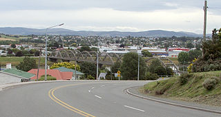
Ranfurly is a town in the Central Otago District of Otago, New Zealand. Located 110 kilometres north of Dunedin, it lies in the dry rough plain of Maniototo at a moderately high altitude close to a small tributary of the Taieri River. It operates as a service town for the local farming community. The town was formerly known as Eweburn, one of the "farmyard" names bestowed by former Otago Chief Surveyor John Turnbull Thomson on many small streams and locations in the district. The modern name honours the Fifth Earl of Ranfurly, who served as Governor of New Zealand (1897–1904) at the time of the extension of the Otago Central Railway to the area. Ranfurly is well known for its Art Deco buildings, such as its hotel and the milk bar.

<span class="mw-page-title-main">Lake Roxburgh</span> Artificial lake in Otago Region, South Island

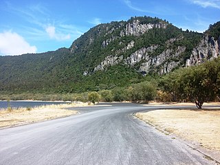
Lake Roxburgh is an artificial lake, created by the Roxburgh Dam, the earliest of the large hydroelectric projects in the southern South Island of New Zealand. It lies on the Clutha River, some 160 km (99 mi) from Dunedin. It covers an area of some 6 km2 (2.3 sq mi), and extends for nearly 30 km (19 mi) towards the town of Alexandra. The town of Roxburgh lies 5 kilometres (3.1 mi) south of the Dam.

<span class="mw-page-title-main">Roxburgh, New Zealand</span> Town in Otago, New Zealand

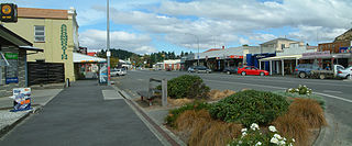
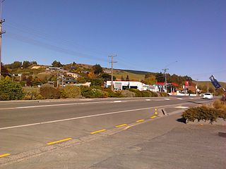
Roxburgh is a small New Zealand town of about 600 people in Central Otago. It is in Teviot Valley on the banks of the Clutha River, 40 kilometres (25 mi) south of Alexandra in the South Island. State Highway 8, which links Central Otago with Dunedin city, passes through the town. Roxburgh is well known for its Summer fruit and "Jimmy's Pies."

<span class="mw-page-title-main">Taieri Mouth</span> Rural settlement in Otago, New Zealand

Taieri Mouth is a small fishing village at the mouth of the Taieri River, New Zealand. Taieri Island (Moturata) lies in the ocean several hundred metres off the river's mouth.

<span class="mw-page-title-main">Central Otago District</span> Territorial authority district in Otago, New Zealand

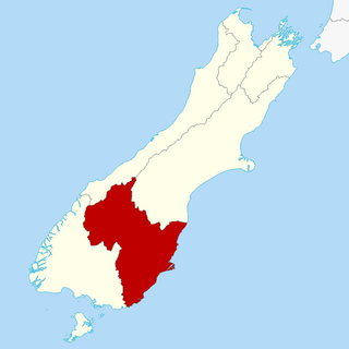
Central Otago District is local government district in New Zealand. It is administered by the Central Otago District Council, and it is in the Otago region, the top tier of local government in New Zealand. The major towns in the district are Alexandra, Cromwell, Roxburgh, Clyde and Ranfurly. The district covers 9,968 km2 (3,849 sq mi), making it the fourth-largest district in New Zealand by area, and is home to 26,000 people as of June 2023.

<span class="mw-page-title-main">Clutha District</span> Territorial authority district in Otago, New Zealand

Clutha District is a local government district of southern New Zealand, with its headquarters in the Otago town of Balclutha. Clutha District has a land area of 6,334.47 km2 (2,445.75 sq mi) and an estimated population of 18,900 as of June 2023. Clutha District occupies the majority of the geographical area known as South Otago.

<span class="mw-page-title-main">Millers Flat</span> Town in the South Island of New Zealand

Millers Flat is a small town in inland Otago, in the South Island of New Zealand. It is located on the Clutha River, 17 kilometres south of Roxburgh. Fruit growing is the main industry in the area. Most of the town lies on the north bank of the Clutha; the main road, State Highway 8, passes close by on the river's other bank. The Roxburgh Branch railway used to pass through the town; it was opened to Millers Flat in 1925 and was the terminus for approximately two and a half years, until the section to Roxburgh was opened. The line was closed in 1968, though the town's station platform and some of the railway formation still exist.

<span class="mw-page-title-main">Owaka</span> Place in Otago, New Zealand

Owaka is a small town in the Clutha District of South Otago, in the South Island of New Zealand. It is the largest community in the rugged, forested Catlins area, close to the border with Southland, some 35 km (22 mi) south of Balclutha on the Southern Scenic Route.

<span class="mw-page-title-main">Clinton, New Zealand</span> Town in Otago, New Zealand

Clinton is a small town in South Otago, in New Zealand's South Island. Handy to the Catlins, Dunedin, Lawrence, Central Otago and Tapanui. It is located on State Highway 1 approximately halfway between Balclutha and Gore, and the Main South Line railway passes through the town.

<span class="mw-page-title-main">Kuratau</span> Settlement in Waikato, New Zealand

Kuratau is a small village north of Pukawa, on the western side of New Zealand's Lake Taupō.

<span class="mw-page-title-main">Waihola</span> Town in Otago, New Zealand

The township of Waihola lies between Dunedin and Milton, New Zealand in Otago, in New Zealand's South Island. It lies close to the southeast shore of the shallow tidal lake which shares its name.

Stirling is a settlement in New Zealand. It is located in South Otago, approximately 5 km from Balclutha, and just north of the Matau Branch of the Clutha River.

<span class="mw-page-title-main">Bannockburn, New Zealand</span> Town in Otago, New Zealand

Bannockburn is a small historic gold mining town located outside of Cromwell in Central Otago, New Zealand.

Pisa Moorings is a small town in the Central Otago District of Otago region of New Zealand's South Island. It is located between Lake Dunstan on its east and State Highway 6 on its west. Cromwell is 9 km southwest and Wānaka is 45 km north by road.

References

  1. 1 2 "ArcGIS Web Application". statsnz.maps.arcgis.com. Retrieved 6 December 2021.
  2. 1 2 "Subnational population estimates (RC, SA2), by age and sex, at 30 June 1996-2023 (2023 boundaries)". Statistics New Zealand . Retrieved 25 October 2023. (regional councils); "Subnational population estimates (TA, SA2), by age and sex, at 30 June 1996-2023 (2023 boundaries)". Statistics New Zealand . Retrieved 25 October 2023. (territorial authorities); "Subnational population estimates (urban rural), by age and sex, at 30 June 1996-2023 (2023 boundaries)". Statistics New Zealand . Retrieved 25 October 2023. (urban areas)
  3. Gilkison, Robert (1958). Early Days in Central Otago. Whitcombe and Tombs Limited. p. 169.
  4. "St Dunstan's Church (Catholic)". Historic Place Category 2 List Number 2387. Heritage New Zealand Pouhere Taonga. Retrieved 5 March 2023.
  5. "Population estimate tables - NZ.Stat". Statistics New Zealand . Retrieved 25 October 2023.
  6. 1 2 "Statistical area 1 dataset for 2018 Census". Statistics New Zealand. March 2020. Clyde (345400). 2018 Census place summary: Clyde
  7. 1 2 "Clyde School Official School Website". clydeschool.co.nz.
  8. "Clyde School Ministry of Education School Profile". educationcounts.govt.nz. Ministry of Education.
  9. "Clyde School Education Review Office Report". ero.govt.nz. Education Review Office.
  10. "Ministry of Education School Profile". educationcounts.govt.nz. Ministry of Education.
  11. "CliFlo – National Climate Database : Clyde Ews". NIWA. Retrieved 19 May 2024.

Commons-logo.svg Media related to Clyde, New Zealand at Wikimedia Commons