
Middlemarch is a small town in the Otago region of New Zealand's South Island. It lies at the foot of the Rock and Pillar Range of hills in the broad Strath-Taieri valley, through which flows the middle reaches of the Taieri River. Since local government reorganisation in the late 1980s, Middlemarch and much of the Strath-Taieri has been administered as part of Dunedin city, the centre of which lies some 80 km to the southeast. Middlemarch is part of the Taieri electorate, and is currently represented in parliament by Ingrid Leary. Middlemarch has reticulated sewerage but no reticulated water supply. A description of 1903, that "[T]he summer seasons are warm, but not enervating, and the winters cold, but dry" is still true today.

The Taieri River is the fourth-longest river in New Zealand and is in Otago in the South Island. Rising in the Lammerlaw Range, it initially flows north, then east around the Rock and Pillar range before turning southeast, reaching the sea 30 kilometres (19 mi) south of Dunedin.
Dunedin Railways is the trading name of Dunedin Railways Limited, an operator of a railway line and tourist trains based at Dunedin Railway Station in the South Island of New Zealand. The company is a council-controlled trading organisation wholly owned by Dunedin City Council through its holding company Dunedin City Holdings Limited.

Strath Taieri is a large glacial valley and river plateau in New Zealand's South Island. It is surrounded by the rugged hill ranges to the north and west of Otago Harbour. Since 1989 it has been part of the city of Dunedin. The small town of Middlemarch is located at its southern end.

The Otago Central Rail Trail is a 150-kilometre walking, cycling and horse riding track in the South Island of New Zealand. A pioneering project for New Zealand, the successful rail trail joined the New Zealand Cycle Trail umbrella organisation in 2012, having been one of the inspirations for it.
Paerau is a small settlement in inland Central Otago in New Zealand's South Island. It is located in the Strath Taieri, the upper valley of the Taieri River, at the foot of the Rock and Pillar Range. "Paerau" is a Māori-language name meaning "one hundred ridges".

The Port Chalmers Branch was the first railway line built in Otago, New Zealand, and linked the region's major city of Dunedin with the port in Port Chalmers. The line is still operational today.
The Waimate Branch was a branch line railway built in southern Canterbury, New Zealand to link the Main South Line with the town of Waimate, the centre of the surrounding rural area. It opened in 1877 and operated until 1966; for some of this time, it included an extension to Waihao Downs that was known as the Waimate Gorge Branch or Waihao Downs Branch. When the line closed, Waimate received the dubious distinction of being New Zealand's first major town to lose its railway line.
The Outram Branch was a branch line railway near Dunedin, Otago, that operated from 1877 to 1953 and formed part of New Zealand's national rail network.

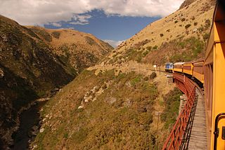
The Otago Central Railway (OCR) or in later years Otago Central Branch Railway, now often referred to as the Taieri Gorge Railway, was a secondary railway line in Central Otago, in the South Island of New Zealand.

Hyde is a locality in Otago, New Zealand, located in the Strath-Taieri. It is close to the northern end of the Rock and Pillar Range on State Highway 87 between Middlemarch and Ranfurly. Hyde is best known as the site of the Hyde railway disaster of 4 June 1943, in which 21 people were killed when an express train on the Otago Central Railway derailed at high speed in a cutting near the town. At the time, it was the worst railway accident in New Zealand's history; it has only been passed by the Tangiwai disaster of 24 December 1953, which claimed the lives of 151 people. The site of the Hyde disaster can now be walked as part of the Otago Central Rail Trail and a monument, a 2.5 m high cairn, stands as a memorial to the victims.
The Roxburgh Branch was a branch line railway built in the Otago region of New Zealand's South Island that formed part of the country's national rail network. Originally known as the Lawrence Branch, it was one of the longest construction projects in New Zealand railway history, beginning in the 1870s and not finished until 1928. The full line was closed in 1968.
The Dunback and Makareao Branches were two connected branch line railways, part of New Zealand's national rail network. Located in the Otago region of the South Island, both lines were 15 km in length and shared the first 11 km. The Dunback Branch, also known as the Waihemo Branch, opened in 1885 and closed in 1968; the Makareao Branch, also known as the Inch Valley Railway or the Inch Valley Branch, opened in 1900 and operated for 89 years to 1989.
Waipiata is an historic place on the Otago Central Rail Trail, in Central Otago, New Zealand. Waipiata is also the name of many New Zealand coastal vessels, steamers, freighters and steamships.
Project Steam is a railway preservation society based in Dunedin, New Zealand. It is dedicated to the restoration of steam locomotives formerly operated by the New Zealand Railways Department, with its goal to restore at least one locomotive to main line operating conditions in order to operate excursions from Dunedin Railway Station. The society is currently the only one of its kind in Dunedin; the Ocean Beach Railway operates small tank locomotives but on private trackage, and the popular Taieri Gorge Limited is run solely by diesel locomotives.

State Highway 87 (SH 87) is a state highway in New Zealand servicing the Taieri Plains and the Strath-Taieri Valley in Otago, connecting Mosgiel to Kyeburn on the eastern flank of the Maniototo Plains.
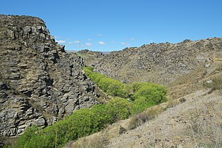
The Poolburn Gorge is a gorge located in the Central Otago region of the South Island of New Zealand, 4 km east of the small settlement of Lauder. The Ida Burn flows through the 2.5 km long canyon across the Raggedy Range between the Ida Valley and the Manuherikia Valley. There are no public roads through the gorge; only the track of the former Otago Central Railway, now used as the Otago Central Rail Trail, follows the river on the southern flanks of the gorge.

Hindon is a small settlement in inland Otago, in the South Island of New Zealand. It is located 24 kilometres (15 mi) northwest of Dunedin in the Silverpeaks Range, close to the edge of the Strath Taieri. The Taieri Gorge Railway runs through Hindon on its way between Dunedin and Middlemarch.
Sutton is a locality in the Strath Taieri, in the southern part of the South Island, New Zealand. It is located on SH 87 close to the point where it is met by the Taieri Gorge rail line, some 5 kilometres to the south of Middlemarch. New Zealand's only salt lake, the Sutton Salt Lake, lies 10 kilometres to the west. Sutton is the location of the Orchard Sun Club, Dunedin's only landed naturist club.

Deep Stream is tributary of the Taieri River in Otago, New Zealand. The stream runs generally eastwards for some 70 kilometres from its source on the slopes of Lammerlaw in the Lammerlaw Range, reaching the Taieri River near Hindon in the Taieri Gorge.
