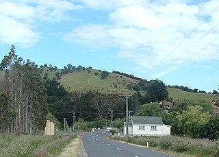
Henley is a township on New Zealand's Taieri Plains, named after the rowing centre Henley-on-Thames in England. It lies close to the confluence of the Taieri and Waipori Rivers at the eastern edge of the plain, at the foot of a low range of coastal hills. The township lies close to the ecologically significant Sinclair Wetlands, which lie 3.5 kilometres (2.2 mi) to the west.

The Taieri River is the fourth-longest river in New Zealand and is in Otago in the South Island. Rising in the Lammerlaw Range, it initially flows north, then east around the Rock and Pillar range before turning southeast, reaching the sea 30 kilometres (19 mi) south of Dunedin.
The Taieri Plain is an area of fertile agricultural land to the southwest of Dunedin, in Otago, New Zealand. The plain covers an area of some 300 square kilometres, with a maximum extent of 30 kilometres. It is not to be confused with Strath Taieri, a second plain of the Taieri River, 40kms to the north beyond Mount Ross.
Dunedin Railways is the trading name of Dunedin Railways Limited, an operator of a railway line and tourist trains based at Dunedin Railway Station in the South Island of New Zealand. The company is a council-controlled trading organisation wholly owned by Dunedin City Council through its holding company Dunedin City Holdings Limited.

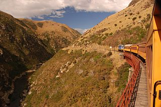
The Silverpeaks is an area of rough forest and tussock and scrub covered hill country inland and to the northwest of Dunedin, New Zealand. The area is largely uninhabited; the main indication of human activity is the Taieri Gorge Railway, which preserves the route of the former Otago Central Railway that runs along the steep-sided valley of the Taieri River. Much of the area lies within the Silverpeaks Scenic Reserve.

The Strath Taieri is a large glacial valley and river plateau in New Zealand's South Island. It is surrounded by the rugged hill ranges to the north and west of Otago Harbour. Since 1989 it has been part of the city of Dunedin. The small town of Middlemarch is located at its southern end.
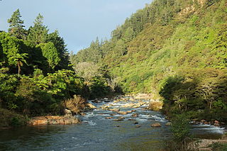
The Ohinemuri River is located in the northern half of New Zealand's North Island, at the base of the Coromandel Peninsula.

Wedderburn is a community in Central Otago, New Zealand. It is located 15 kilometres northwest of Ranfurly, and was at one time close to the centre of a thriving gold and coal mining area. The name of Wedderburn was given to the area by John Turnbull Thomson, and is one of the names in his infamous "Thomson's Barnyard", wedder being Northumbrian dialect form of the word wether, meaning a castrated sheep.

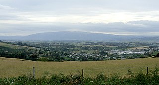
Outram is a rural suburb of Dunedin, New Zealand, with a population of 880 as of June 2023. It is located 28 kilometres west of the central city at the edge of the Taieri Plains, close to the foot of Maungatua. The Taieri River flows close to the southeast of the town. Outram lies on State Highway 87 between Mosgiel and Middlemarch.

Patearoa is a small settlement in inland Otago in New Zealand's South Island. It is located 20 kilometres southwest of Ranfurly, in the Maniototo and was originally known as Sowburn. Andrew Buchanan was an early runholder in Patearoa.
Paerau is a small settlement in inland Central Otago in New Zealand's South Island. It is located in the Strath Taieri, the upper valley of the Taieri River, at the foot of the Rock and Pillar Range. "Paerau" is a Māori-language name meaning "one hundred ridges".
The Outram Branch was a branch line railway near Dunedin, Otago, that operated from 1877 to 1953 and formed part of New Zealand's national rail network.

The Otago Central Railway (OCR) or in later years Otago Central Branch Railway, now often referred to as the Taieri Gorge Railway, was a secondary railway line in Central Otago, in the South Island of New Zealand.
Allanton is a small town in Otago, New Zealand, located some 20 kilometres southwest of Dunedin on State Highway 1. The settlement lies at the eastern edge of the Taieri Plains close to the Taieri River at the junction of the main road to Dunedin International Airport at Momona.
Waipiata is an historic place on the Otago Central Rail Trail, in Central Otago, New Zealand. Waipiata is also the name of many New Zealand coastal vessels, steamers, freighters and steamships.

Hindon is a small settlement in inland Otago, in the South Island of New Zealand. It is located 24 kilometres (15 mi) northwest of Dunedin in the Silverpeaks Range, close to the edge of the Strath Taieri. The Taieri Gorge Railway runs through Hindon on its way between Dunedin and Middlemarch.
Kyeburn is a small settlement in Otago, in the South Island of New Zealand. It lies on the Maniototo, a wide, high plain stretching from the end of the Strath-Taieri valley.
Sutton is a locality in the Strath Taieri, in the southern part of the South Island, New Zealand. It is located on SH 87 close to the point where it is met by the Taieri Gorge rail line, some 5 kilometres to the south of Middlemarch. New Zealand's only salt lake, the Sutton Salt Lake, lies 10 kilometres to the west. Sutton is the location of the Orchard Sun Club, Dunedin's only landed naturist club.

The Wingatui railway station, sometimes known as the Wingatui Junction railway station, is a former station between Dunedin and Mosgiel in Otago, New Zealand. On the Main South Line, it is the junction for the Otago Central Railway

Deep Stream is a tributary of the Taieri River in Otago, New Zealand. The stream runs generally eastwards for some 70 kilometres from its source on the slopes of Lammerlaw in the Lammerlaw Range, reaching the Taieri River near Hindon in the Taieri Gorge.
