The area around modern Brighton was not the site of permanent settlement by pre-colonial māori, but was on their regular trails from their homes on Otago Peninsula to their traditional hunting grounds. Archaeological evidence suggests that the area around Brighton was the site of seal and sea lion hunting, as well as hunting of moa. Stone tool making may have also taken place around the area.
European settlement begn in the 1860s. The town was named by an early resident, Hugh Williams, after Brighton in England.[4] Early industries included coal mining, with lignite being plentiful at nearby Ocean View. The town was also a service town for the local farming community. During the early 20th century, the town was a popular resort for people from nearby Dunedin, with several guest houses. With increased motorised transport, the town became a commuter settlement and day-trip destination after World War II.
Geography
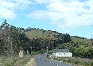
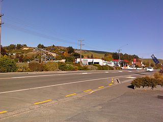
Brighton is connected by coastal road with the Dunedin commuter settlement of Waldronville to the northeast (and from there to Dunedin itself) and with Taieri Mouth to the southwest. The settlement of Ocean View lies immediately to the east of Brighton, separated from it by a large bluff (simply known as "Big Rock") which juts towards the ocean to the northeast of Brighton Beach. The coast road winds around this headland on its entry to Brighton from Dunedin.
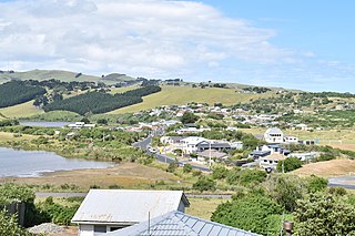
The town faces a small bay which includes a broad sheltered beach, Brighton Beach, and other beaches extend from here, north and east to Waldronville Lagoon and south and west to Taieri Mouth. They make the area popular for summer day trips from Dunedin. At the southern end of Brighton Beach is the mouth of the Otokia Creek, a small stream which has its sources 10 kilometres (6.2mi) to the southwest in the coastal hills which separate the coast from the Taieri Plains. A small reserve and walkway links the town's main road with the mouth of the Otokia Creek. The reserve contains abundant birdlife, including oystercatchers and spoonbills.
Demographics
Brighton covers 3.40km2 (1.31sqmi)[2] and had an estimated population of 1,540 as of June 2023,[3] with a population density of 453 people per km2.
Brighton Beach, immediately to the southeast of the town
Brighton had a population of 1,473 at the 2018 New Zealand census, an increase of 27 people (1.9%) since the 2013 census, and a decrease of 36 people (−2.4%) since the 2006 census. There were 615 households, comprising 756 males and 717 females, giving a sex ratio of 1.05 males per female. The median age was 44.2 years (compared with 37.4 years nationally), with 264 people (17.9%) aged under 15 years, 213 (14.5%) aged 15 to 29, 768 (52.1%) aged 30 to 64, and 228 (15.5%) aged 65 or older.
Ethnicities were 93.5% European/Pākehā, 10.4% Māori, 1.6% Pasifika, 2.9% Asian, and 2.2% other ethnicities. People may identify with more than one ethnicity.
The percentage of people born overseas was 15.9, compared with 27.1% nationally.
Although some people chose not to answer the census's question about religious affiliation, 59.5% had no religion, 28.7% were Christian, 0.2% had Māori religious beliefs, 0.4% were Hindu, 0.2% were Buddhist and 2.4% had other religions.
Of those at least 15 years old, 243 (20.1%) people had a bachelor's or higher degree, and 240 (19.9%) people had no formal qualifications. The median income was $34,400, compared with $31,800 nationally. 186 people (15.4%) earned over $70,000 compared to 17.2% nationally. The employment status of those at least 15 was that 645 (53.3%) people were employed full-time, 204 (16.9%) were part-time, and 39 (3.2%) were unemployed.[5]
Education
Big Rock Primary School is a full primary school serving years 1 to 8[6] with a roll of 100 students as of February 2024.[7] The school was created when Brighton and Ocean View schools merged in 2008.[8]
Otago is a region of New Zealand located in the southern half of the South Island administered by the Otago Regional Council. It has an area of approximately 32,000 square kilometres (12,000 sq mi), making it the country's second largest local government region. Its population was 254,600 in June 2023.
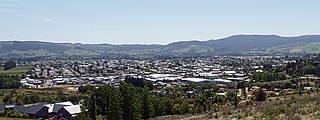
Middlemarch is a small town in the Otago region of New Zealand's South Island. It lies at the foot of the Rock and Pillar Range of hills in the broad Strath-Taieri valley, through which flows the middle reaches of the Taieri River. Since local government reorganisation in the late 1980s, Middlemarch and much of the Strath-Taieri has been administered as part of Dunedin city, the centre of which lies some 80 km to the southeast. Middlemarch is part of the Taieri electorate, and is currently represented in parliament by Ingrid Leary. Middlemarch has reticulated sewerage but no reticulated water supply. A description of 1903, that "[T]he summer seasons are warm, but not enervating, and the winters cold, but dry" is still true today.
Henley is a township on New Zealand's Taieri Plains, named after the rowing centre Henley-on-Thames in England. It lies close to the confluence of the Taieri and Waipori Rivers at the eastern edge of the plain, at the foot of a low range of coastal hills. The township lies close to the ecologically significant Sinclair Wetlands, which lie 3.5 kilometres (2.2 mi) to the west.
Dunedin is the second-largest city in the South Island of New Zealand, and the principal city of the Otago region. Its name comes from Dùn Èideann, the Scottish Gaelic name for Edinburgh, the capital of Scotland. The city has a rich Māori, Scottish, and Chinese heritage.
Mosgiel is an urban satellite of Dunedin in Otago, New Zealand, fifteen kilometres west of the city's centre. Since the re-organisation of New Zealand local government in 1989 it has been inside the Dunedin City Council area. Mosgiel has a population of approximately 14,800 as of June 2023. A nickname for Mosgiel is "The pearl of the plain". Its low-lying nature does pose problems, making it prone to flooding after heavy rains. Mosgiel takes its name from Mossgiel Farm, Ayrshire, the farm of the poet Robert Burns, the uncle of the co-founder in 1848 of the Otago settlement, the Reverend Thomas Burns.
South Otago lies in the south east of the South Island of New Zealand. As the name suggests, it forms the southernmost part of the geographical region of Otago.
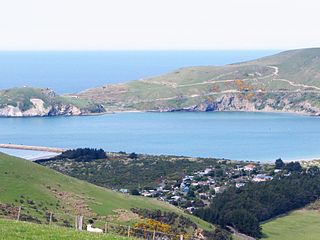
Taieri Mouth is a small fishing village at the mouth of the Taieri River, New Zealand. Taieri Island (Moturata) lies in the ocean several hundred metres off the river's mouth.
The Strath Taieri is a large glacial valley and river plateau in New Zealand's South Island. It is surrounded by the rugged hill ranges to the north and west of Otago Harbour. Since 1989 it has been part of the city of Dunedin. The small town of Middlemarch is located at its southern end.
Aramoana is a small coastal settlement 27 kilometres (17 mi) north of Dunedin on the South Island of New Zealand. The settlement's permanent population in the 2001 Census was 261. Supplementing this are seasonal visitors from the city who occupy cribs. The name Aramoana is Māori for "pathway of the sea".
Clutha District is a local government district of southern New Zealand, with its headquarters in the Otago town of Balclutha. Clutha District has a land area of 6,334.47 km2 (2,445.75 sq mi) and an estimated population of 18,900 as of June 2023. Clutha District occupies the majority of the geographical area known as South Otago.
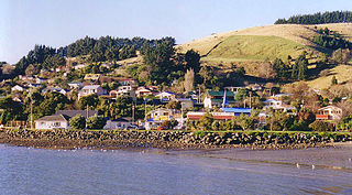
Macandrew Bay is located on the Otago Peninsula in the South Island of New Zealand. It is situated on the edge of Otago Harbour, and is named for pioneer Scottish settler James Macandrew who lived here during his later life. The Te Reo Māori name for the bay, Te Roto Pāteke, refers to the Brown teal formerly prevalent in the area. Early European residents of the area called the bay "The Hundreds", due to the large number of boulders which covered the foreshore.
Outram is a rural suburb of Dunedin, New Zealand, with a population of 880 as of June 2023. It is located 28 kilometres west of the central city at the edge of the Taieri Plains, close to the foot of Maungatua. The Taieri River flows close to the southeast of the town. Outram lies on State Highway 87 between Mosgiel and Middlemarch.
Allanton is a small town in Otago, New Zealand, located some 20 kilometres southwest of Dunedin on State Highway 1. The settlement lies at the eastern edge of the Taieri Plains close to the Taieri River at the junction of the main road to Dunedin International Airport at Momona.
The township of Waihola lies between Dunedin and Milton, New Zealand in Otago, in New Zealand's South Island. It lies close to the southeast shore of the shallow tidal lake which shares its name.
Waldronville is a coastal settlement on the Pacific Ocean coast of the South Island of New Zealand. Established in the 1950s as a commuter settlement, it is located 13 kilometres (8.1 mi) to the southwest of Dunedin city centre, and lies within the city's limits. Waldronville was developed by Bill Waldron, when he purchased the McCraws farm in the early 1950s, initially for 200 houses. In the mid-1970s, two other streets were added to the southwest of the settlement. In the mid-1990s, Friendship Drive and Wavy Knowes developments were added to the northeast.
Ocean Grove, also known as Tomahawk, is a suburb in the southeast of the New Zealand city of Dunedin. A semi-rural residential suburb on the Pacific coast at the southwestern end of the Otago Peninsula, Ocean Grove is located 6.5 kilometres (4.0 mi) southeast of Dunedin city centre.
Halfway Bush is a suburb of the New Zealand city of Dunedin. It is located 3 kilometres (1.9 mi) to the northwest of the city centre, close to the point at which Taieri Road becomes the winding rural Three Mile Hill Road. It was this road which gave the suburb its name, as this locality was halfway between the Taieri Plains and central Dunedin in the early days of European settlement, when Three Mile Hill was the main route from Dunedin to the Otago hinterland. This route was superseded by the route through the Caversham Valley in the 1860s.
Corstorphine is a suburb of southwest Dunedin in the South Island of New Zealand. It is located on the slopes of Calton Hill - a spur of Forbury Hill - between Caversham Valley and the Pacific Ocean. The suburbs of Saint Clair and Forbury lie to the east and south, and Caversham and Lookout Point lie to the north.
East Taieri is a small township, located between Mosgiel and Allanton in New Zealand's Otago region. It lies on State Highway 1 en route between the city of Dunedin and its airport at Momona. It lies close to the southeastern edge of the Taieri Plain, hence its name.
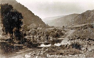
Whare Flat is a locality some 15 km to the northwest of Dunedin city centre, in the South Island of New Zealand. It is located at a widening of the Silver Stream's valley amid the foothills of the Silverpeaks.
This page is based on this Wikipedia article Text is available under the CC BY-SA 4.0 license; additional terms may apply. Images, videos and audio are available under their respective licenses.