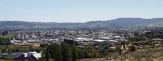
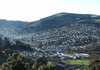
Mosgiel is an urban satellite of Dunedin in Otago, New Zealand, fifteen kilometres west of the city's centre. Since the re-organisation of New Zealand local government in 1989 it has been inside the Dunedin City Council area. Mosgiel has a population of approximately 14,700 as of June 2021. The town celebrates its location, calling itself "The pearl of the plain". Its low-lying nature does pose problems, making it prone to flooding after heavy rains. Mosgiel takes its name from Mossgiel Farm, Ayrshire, the farm of the poet Robert Burns, the uncle of the co-founder in 1848 of the Otago settlement, the Reverend Thomas Burns.

Otakou is a settlement within the boundaries of the city of Dunedin, New Zealand. It is located 25 kilometres from the city centre at the eastern end of Otago Peninsula, close to the entrance of Otago Harbour. Though a small fishing village, Otakou is important in the history of Otago for several reasons. The settlement is the modern centre and traditional home of the Ōtākou rūnanga (assembly) of Ngāi Tahu. In 1946 Otakou Fisheries was founded in the township; this was later to become a major part of the Otago fishing industry.
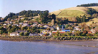
Macandrew Bay is located on the Otago Peninsula in the South Island of New Zealand. It is situated on the edge of Otago Harbour, and is named for pioneer European settler James Macandrew who lived here during his later life. The Te Reo Māori name for the bay, Te Roto Pāteke, refers to the Brown teal formerly prevalent in the area. Early European residents of the area called the bay "The Hundreds", due to the large number of boulders which covered the foreshore.

Mount Cargill, known in Māori as Kapukataumahaka, is a volcanic outcrop which dominates the skyline of northern Dunedin, New Zealand.

Fairfield is a suburb of Dunedin, New Zealand.
Waverley is a suburb of the New Zealand city of Dunedin. It was named after Sir Walter Scott's novel Waverley, first novel in a series known as the Waverley Novels, among the most popular and widely read English-language novels of the 19th century. Waverley is located at the start of the Otago Peninsula, 2.4 kilometres (1.5 mi) southeast of the city centre, on a rise overlooking the Otago Harbour to the north.
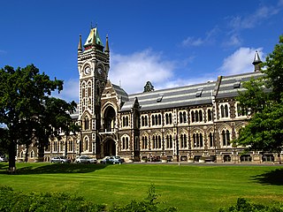
Dunedin North, also known as North Dunedin, is a major inner suburb of the New Zealand city of Dunedin, located 1.5 kilometres (0.93 mi) northeast of the city centre. It contains many of the city's major institutions, including the city's university, polytechnic, main hospital, and largest museum. Dunedin North's 2001 population was 7,047, including the university area.

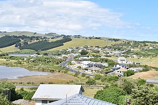
The settlement of Broad Bay is located on the Otago Harbour coast of Otago Peninsula, in the South Island of New Zealand. It is administered as part of the city of Dunedin, and is technically a suburb of that city, though its isolation and semi-rural nature make it appear as a settlement in its own right.
Waldronville is a coastal settlement on the Pacific Ocean coast of the South Island of New Zealand. Established in the 1950s as a commuter settlement, it is located 13 kilometres (8.1 mi) to the southwest of Dunedin city centre, and lies within the city's limits. Waldronville was developed by Bill Waldron, when he purchased the McCraws farm in the early 1950s, initially for 200 houses. In the mid-1970s, two other streets were added to the southwest of the settlement. In the mid-1990s, Friendship Drive and Wavy Knowes developments were added to the northeast.
Ocean Grove, also known as Tomahawk and Toma haka in Te Reo Maori, is a suburb in the southeast of the New Zealand city of Dunedin. A semi-rural residential suburb on the Pacific coast at the southwestern end of the Otago Peninsula, Ocean Grove is located 6.5 kilometres (4.0 mi) southeast of Dunedin city centre.

Sawyers Bay is a suburb of the New Zealand city of Dunedin. It is located 1.5 kilometres (0.93 mi) to the southwest of Port Chalmers in a wide valley on the shore of Mussel Bay, 13 kilometres (8.1 mi) to the northeast of Dunedin city centre.
Ōpoho is a suburb of the New Zealand city of Dunedin. It sits on the western flank of Signal Hill, New Zealand, 3 kilometres (1.9 mi) to the northeast of the city centre, overlooking North East Valley and the Dunedin Botanic Gardens.

Māori Hill is a residential suburb of the New Zealand city of Dunedin. It is located at the northern end of the ridge which runs in a crescent around the central city's western edge, 2 kilometres (1.2 mi) to the northwest of the city centre, immediately above and within the Town Belt. It is connected to Dunedin North, which lies to the east, via Drivers Road, the suburbs of Roslyn and Kaikorai to the southwest via Highgate, and the suburb of Wakari to the northwest via Balmacewen Road.

South Dunedin is a major inner city suburb of the New Zealand city of Dunedin. It is located, as its name suggests, 2.5 kilometres (1.6 mi) to the south of the city centre, on part of a large plain known locally simply as "The Flat". The suburb is a mix of industrial, retail, and predominantly lower-quality residential properties.
Calton Hill is an elevated southern residential suburb of the City of Dunedin in New Zealand's South Island. The suburb is named after Calton Hill in Edinburgh, Scotland, and some of its street names carry similar etymological roots.

Ravensbourne is a suburb of the New Zealand city of Dunedin. It is located on Otago Harbour on the steep southeastern slopes of Signal Hill. It lies on the harbour's northern shore, 4.5 kilometres (2.8 mi) east-northeast of the city centre.

Challis is a settlement on the Otago Harbour coast of Otago Peninsula, within the city limits of the New Zealand city of Dunedin. Though officially regarded as a suburb, the isolated nature of Challis means that most locals regard it as a separate settlement within the city limits.
Shiel Hill is a residential suburb of the New Zealand city of Dunedin. It is located at the southeastern edge of the city's urban area, 3.2 kilometres (2.0 mi) southeast of the city's centre at the western end of the Otago Peninsula, close to the isthmus joining the peninsula to the mainland. As the name suggests, it is situated on the slopes of a hill at the start of the ridge which runs along the spine of the peninsula. The slopes rise to a series of crests generally known collectively as Highcliff, a name also often applied to the last suburban vestiges which remain as Dunedin's urban area becomes the rural land of the peninsula. More accurately, the name is that of a cliff which lies on the Pacific coast of the peninsula 4 kilometres (2.5 mi) east of Shiel Hill.

Wingatui is a small settlement almost 15 kilometres west of Dunedin, and two kilometres east of Mosgiel. It has become a suburb of Mosgiel, but continues to maintain its own unique identity and heritage.
Horbourside is a reclaimed area of land at the head of Otago Harbour in Dunedin, New Zealand. It is separated from the Dunedin central business district by the Main South Line. Most of the land was reclaimed in the 19th century. It is a port and industrial/warehousing area.


