Gaines, New York

Last updated

Gaines, New York
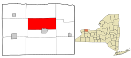
Orleans County New York incorporated and unincorporated areas Gaines highlighted.svg
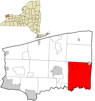
Location in Orleans County and the state of New York.
New York in United States (US48).svg
Location of New York in the United States
Coordinates: 43°15′45″N78°11′28″W / 43.26250°N 78.19111°W / 43.26250; -78.19111
Country United States
State New York
County Orleans
Area
[1]
  Total34.46 sq mi (89.25 km2)
  Land34.42 sq mi (89.15 km2)
  Water0.04 sq mi (0.10 km2)
Elevation
430 ft (131 m)
Population
 (2010)
  Total3,378
  Estimate 
(2016) [2]
3,227
  Density93.76/sq mi (36.20/km2)
Time zone UTC-5 (Eastern (EST))
  Summer (DST) UTC-4 (EDT)
FIPS code 36-27958
GNIS feature ID0978981

Gaines is a town in Orleans County, [3] New York, [4] United States. The population was 3,226 at the 2020 census, [5] and 3,378 at the 2010 census. The town is named after General Edmund P. Gaines, [6] who defended the area during the War of 1812.

Contents

The Town of Gaines [7] is in the north-central part of the county and contains part of the Village of Albion, [8] the county seat. The current supervisor of Gaines is Tyler James Allport.

History

The Town of Gaines [7] was established in 1816 from a partition of the Town of Ridgeway [9] [10] [11] [12] before Orleans County [3] was established.

In 1890, the population of Gaines was 2,070.

Geography

According to the United States Census Bureau, [13] the town has a total area of 34.4 square miles (89 km2), of which 34.4 square miles (89 km2) is land and 0.04 square miles (0.10 km2) (0.12%) is water.

The Erie Canal [14] touches the southern boundary of the town at Gaines Basin, and the Oak Orchard River [15] flows through the northwest part of the town entering the Town of Carlton. [16] The northernmost point on the Erie Canal is located in Gaines.

New York State Route 104 [17] (Ridge Road) is an east–west highway across the town. New York State Route 98 [18] (Oak Orchard Road) is a north–south highway, intersecting NY-104 north of the village of Albion at Childs. New York State Route 279 [19] (Gaines Waterport Road) is a north–south highway intersecting NY-104 at Gaines village.

Demographics

Historical population
CensusPop.Note
1820 1,134
1830 2,12187.0%
1840 2,2686.9%
1850 2,72220.0%
1860 2,542−6.6%
1870 2,196−13.6%
1880 2,3386.5%
1890 2,070−11.5%
1900 1,889−8.7%
1910 1,9463.0%
1920 1,669−14.2%
1930 1,7022.0%
1940 1,667−2.1%
1950 1,8128.7%
1960 2,09015.3%
1970 2,38514.1%
1980 2,69212.9%
1990 3,02512.4%
2000 3,74023.6%
2010 3,378−9.7%
2016 (est.)3,227 [2] −4.5%
U.S. Decennial Census [20]

As of the census [21] of 2000, there were 3,740 people, 1,474 households, and 986 families residing in the town. The population density was 108.8 inhabitants per square mile (42.0/km2). There were 1,609 housing units at an average density of 46.8 per square mile (18.1/km2). The racial makeup of the town was 91.63% White, 4.41% African American, 0.32% Native American, 0.13% Asian, 2.19% from other races, and 1.31% from two or more races. Hispanic or Latino of any race were 4.14% of the population.

There were 1,474 households, out of which 32.0% had children under the age of 18 living with them, 50.0% were married couples living together, 11.5% had a female householder with no husband present, and 33.1% were non-families. 27.2% of all households were made up of individuals, and 16.8% had someone living alone who was 65 years of age or older. The average household size was 2.54 and the average family size was 3.06.

In the town, the population was spread out, with 26.4% under the age of 18, 7.9% from 18 to 24, 28.0% from 25 to 44, 21.9% from 45 to 64, and 15.8% who were 65 years of age or older. The median age was 38 years. For every 100 females, there were 92.6 males. For every 100 females age 18 and over, there were 86.8 males.

The median income for a household in the town was $32,604, and the median income for a family was $38,523. Males had a median income of $30,709 versus $21,917 for females. The per capita income for the town was $16,823. About 7.9% of families and 10.3% of the population were below the poverty line, including 20.4% of those under age 18 and 7.0% of those age 65 or over.

Communities and locations in the Town of Gaines

Notable people

Related Research Articles

<span class="mw-page-title-main">Orleans County, New York</span> County in New York, United States

Orleans County is a county in the western part of the U.S. state of New York. As of the 2020 census, the population was 40,343. The county seat is Albion. The county received its name at the insistence of Nehemiah Ingersoll though historians are unsure how the name was selected. The two competing theories are that it was named to honor the French Royal House of Orleans or that it was to honor Andrew Jackson's victory in New Orleans. The county is part of the Finger Lakes region of the state.

<span class="mw-page-title-main">Clarkson, New York</span> Town in Monroe County, New York, United States

Clarkson is a town in Monroe County, New York, United States. The population was 6,904 at the 2020 census. The town is named after General Matthew Clarkson.

<span class="mw-page-title-main">Hartland, New York</span> Town in New York, United States

Hartland is a town in Niagara County, New York, United States. The population was 4,117 at the 2010 census. The town is named after Hartland, Vermont, the homeplace of some early settlers.
<span class="mw-page-title-main">Royalton, New York</span> Town in New York, United States

Royalton is a town in Niagara County, New York, United States. The population was 7,660 at the 2010 census.

<span class="mw-page-title-main">Verona, New York</span> Town in New York, United States

Verona is a town in southwestern Oneida County, New York, United States. The population was 6,293 at the 2010 census. The town was named after Verona, Italy.
<span class="mw-page-title-main">Carlton, New York</span> Town in New York, United States

Carlton is a town in Orleans County, New York, United States. The population was 2,994 at the 2010 census. The name is derived from Carleton, a shipbuilding district near Ottawa, Ontario, Canada.

<span class="mw-page-title-main">Medina, New York</span> Village in New York, United States

Medina is a village in the Towns of Shelby and Ridgeway in Orleans County, New York, United States. It is located approximately 10 miles south of Lake Ontario. The population was 6,065 at the 2010 census, making it the county's most populous municipality. The village was named by its surveyor, Ebenezer Mix. It is part of the Rochester Metropolitan Statistical Area. The Medina zip code, 14103, encompasses the village of Medina and the surrounding towns of Ridgeway and Shelby. The United States Census Bureau estimates the 2017 population of this area to be 17,234.

<span class="mw-page-title-main">Murray, New York</span> Town in Orleans County, New York

Murray is a town in Orleans County, New York, United States. The population was 6,259 at the 2000 census.

<span class="mw-page-title-main">Ridgeway, New York</span> Town in New York, United States

Ridgeway is a town in Orleans County, New York, United States. The population was 6,886 at the 2000 census. The name of the town is derived from "Ridge Road," an important highway in the 19th century.

<span class="mw-page-title-main">Shelby, New York</span> Town in New York, United States

Shelby is a town in Orleans County, New York, United States. The population was 5,319 at the 2010 census.
<span class="mw-page-title-main">Tyre, New York</span> Town in New York, United States

Tyre is a town in Seneca County, New York, United States. The population was 1,002 at the 2020 census. The town is named after the Lebanese city of Tyre.

<span class="mw-page-title-main">Albion (village), New York</span> Village in New York, United States

Albion is a village in Orleans County, New York, United States. The population was 5,637 as of the 2020 census, down 419 from the 2010 census. The village is centrally located in the county, and is partly within the towns of both Albion and Gaines. It is the county seat of Orleans County and is about 30 miles (48 km) west/northwest of Rochester. Albion is part of the Rochester metropolitan area.

<span class="mw-page-title-main">Albion, Orleans County, New York</span> Town in New York, United States

Albion is a town in Orleans County, New York, United States. The population was 7,639 at the 2020 census. The town was named after a village in the town.

<span class="mw-page-title-main">Orchard Park, New York</span> Town in New York, United States

Orchard Park is an incorporated town in Erie County, New York, United States. It is an outer ring suburb southeast of Buffalo. As of the 2010 census, the population was 29,054, representing an increase of 5.13% from the 2000 census figure. The town contains a village also named Orchard Park. Orchard Park is one of the Southtowns of Erie County and is best known as the site of Highmark Stadium, home of the National Football League's Buffalo Bills.

<span class="mw-page-title-main">Oak Orchard Creek</span> River in New York, United States

Oak Orchard Creek is a tributary of Lake Ontario in Orleans County, New York in the United States.

<span class="mw-page-title-main">New York State Route 31</span> Highway in New York

New York State Route 31 (NY 31) is a state highway that extends for 208.74 miles (335.93 km) across western and central New York in the United States. The western terminus of the route is at an intersection with NY 104 in the city of Niagara Falls. Its eastern terminus is at a traffic circle with NY 26 in Vernon Center, a hamlet within the town of Vernon. Over its routing, NY 31 spans 10 counties and indirectly connects three major urban areas in Upstate New York: Buffalo–Niagara Falls, Rochester, and Syracuse. The route is one of the longest routes in New York State, paralleling two similarly lengthy routes, NY 104 to the north and NY 5 to the south, as well as the Erie Canal, as it proceeds east.

<span class="mw-page-title-main">New York State Route 98</span> Highway in western New York

New York State Route 98 (NY 98) is a state highway in the western part of New York in the United States. The southern terminus of the route is at an intersection with U.S. Route 219 (US 219) in the town of Great Valley in Cattaraugus County. The northern end is at an interchange with the Lake Ontario State Parkway in the town of Carlton in Orleans County, near the southern shore of Lake Ontario. In between, NY 98 serves the city of Batavia, connects to the New York State Thruway, and passes by the Attica Correctional Facility. Most of the route passes through rural, undeveloped areas; however, in southern Genesee County, it traverses more urbanized areas that lie in and around Batavia.
<span class="mw-page-title-main">New York State Route 279</span> State highway in Orleans County, New York, US

New York State Route 279 (NY 279) is a north–south state highway in Orleans County, New York, in the United States. The southern terminus of the route is at an intersection with NY 98 north of the village of Albion in the town of Gaines. Its northern terminus is at a junction with NY 18 in Carlton near where NY 18 meets the western end of the Lake Ontario State Parkway. The entirety of NY 279 north of NY 104 is maintained by Orleans County; south of NY 104, the route is maintained by the New York State Department of Transportation. NY 279 is a rural connector highway that serves only one community, the hamlet of Waterport on the banks of Oak Orchard Creek in Carlton.

<span class="mw-page-title-main">New York State Route 31E</span> State highway in western New York, US

New York State Route 31E (NY 31E) is a 5.29-mile (8.51 km) state highway located in western New York in the United States. It serves as a northerly alternate route of NY 31 between the village of Middleport in eastern Niagara County and the nearby village of Medina in Orleans County. NY 31E connects to NY 31 at each end by way of a short overlap with NY 271 in Middleport. Most of NY 31E parallels the Erie Canal, and parts of the route run adjacent to the waterway. Outside of the two villages at each end, NY 31E traverses mostly rural areas of the towns of Royalton and Ridgeway.

<span class="mw-page-title-main">Lyons, New York</span> Town in New York, United States

Lyons is a town in and the county seat of Wayne County, New York, United States. The population was 5,682 at the 2010 census. It is named after Lyon, France.
References

  1. "2016 U.S. Gazetteer Files". United States Census Bureau. Retrieved July 5, 2017.
  2. 1 2 "Population and Housing Unit Estimates" . Retrieved June 9, 2017.
  3. 1 2 "Orleans County, NY". orleanscountyny.com. Retrieved March 15, 2022.
  4. "Welcome to NYC.gov | City of New York". www1.nyc.gov. Retrieved March 16, 2022.
  5. "Explore Census Data". data.census.gov. Retrieved May 23, 2024.
  6. Gannett, Henry (1905). The Origin of Certain Place Names in the United States. Govt. Print. Off. p. 133.
  7. 1 2 "Town of Gaines – Orleans County, NY". www.townofgaines.org. Retrieved March 15, 2022.
  8. "Village of Albion Official Website - Albion, NY". villageofalbionny.com. Archived from the original on March 3, 2022. Retrieved March 16, 2022.
  9. "Town of Ridgeway". ridgewaysc.org. Retrieved March 15, 2022.
  10. "Town of Ridgeway – For the people, by the people…" . Retrieved March 15, 2022.
  11. "Town of Ridgeway, Iowa County, Wisconsin | Official Website". townofridgeway.org. Retrieved March 15, 2022.
  12. "Welcome to the Official Website of Iowa County, WITown of Ridgeway". www.iowacounty.org. Retrieved March 15, 2022.
  13. Bureau, US Census. "Census.gov". Census.gov. Retrieved March 15, 2022.
  14. "The Erie Canal". www.eriecanal.org. Retrieved March 15, 2022.
  15. "Oak Orchard River & Marsh Creek" (PDF).
  16. "Town of Carlton" . Retrieved March 15, 2022.
  17. "Route 104 - AARoads - New York". AARoads. Retrieved March 15, 2022.
  18. "NY Route 98 on the New York State Thruway – New York". turnpikeinfo.com. Retrieved March 15, 2022.
  19. "NY 279 Map,Traffic,Road Condition,Weather,New York - Roadnow". roadnow.com. Retrieved March 15, 2022.
  20. "Census of Population and Housing". Census.gov. Retrieved June 4, 2015.
  21. "U.S. Census website". United States Census Bureau . Retrieved January 31, 2008.

43°17′06″N78°12′55″W / 43.28500°N 78.21528°W / 43.28500; -78.21528